

mahantango#1
-
Posts
5,043 -
Joined
-
Last visited
Content Type
Profiles
Blogs
Forums
American Weather
Media Demo
Store
Gallery
Everything posted by mahantango#1
-

The Ides of March end of Winter 2023
mahantango#1 replied to paweather's topic in Upstate New York/Pennsylvania
Nws had it in their forecast 2 hrs ago...now theres no mention of it. -
The Ides of March end of Winter 2023
mahantango#1 replied to paweather's topic in Upstate New York/Pennsylvania
The question is will we get thunderstorms in the Susquehanna Valley this later today? -
The Ides of March end of Winter 2023
mahantango#1 replied to paweather's topic in Upstate New York/Pennsylvania
Temps are falling Was 49 when I got up at 5:15am now it's 43. -
The Ides of March end of Winter 2023
mahantango#1 replied to paweather's topic in Upstate New York/Pennsylvania
Just had extremely bright lightning and a close strike. -
The Ides of March end of Winter 2023
mahantango#1 replied to paweather's topic in Upstate New York/Pennsylvania
.30 rain so far today -
The Ides of March end of Winter 2023
mahantango#1 replied to paweather's topic in Upstate New York/Pennsylvania
The clock is ticking on these winter events. But I know (as we all know) it is still in the realm of possibility that we could get one of these events. -
The Ides of March end of Winter 2023
mahantango#1 replied to paweather's topic in Upstate New York/Pennsylvania
Took advantage of the beautiful weather yesterday to plow our garden. Now we will go into a wetter weather pattern. I doubt anything will get planted for at least a month or later from now. Soil conditions were perfect for plowing. There are not too many times you get to plow in March especially the bottom lands. I could have plowed in February too as ground conditions were good also. Like Comment Share -
The Ides of March end of Winter 2023
mahantango#1 replied to paweather's topic in Upstate New York/Pennsylvania
After I eat I intend to get the tractor out and the plow to plow our truck patch garden. It's the perfect time to do it before it rains. Once it rain who knows when I'll get to do it. And the garden sits in the lowland next to the creek. -
The Ides of March end of Winter 2023
mahantango#1 replied to paweather's topic in Upstate New York/Pennsylvania
No mow here, there are very few high spots very dry here. -
The Ides of March end of Winter 2023
mahantango#1 replied to paweather's topic in Upstate New York/Pennsylvania
21 this morning. Might drop another degree or so till sunrise. The question now is the (one we all ask every year), did this cold hurt the fruit trees, and other tender vegetation? -
The Ides of March end of Winter 2023
mahantango#1 replied to paweather's topic in Upstate New York/Pennsylvania
High today was 54 what a spectacular day compared to yesterday. -
The Ides of March end of Winter 2023
mahantango#1 replied to paweather's topic in Upstate New York/Pennsylvania
A very cold frosty 17 this morning, just what month is this? Feels like its January instead of the latter part of March. -
The Ides of March end of Winter 2023
mahantango#1 replied to paweather's topic in Upstate New York/Pennsylvania
High today was 39 here...still a cold miserable day with the wind, despite the sun. -
The Ides of March end of Winter 2023
mahantango#1 replied to paweather's topic in Upstate New York/Pennsylvania
Keeping Blizz's hopes alive. -
The Ides of March end of Winter 2023
mahantango#1 replied to paweather's topic in Upstate New York/Pennsylvania
A cold 22 this morning, feels like January. -
The Ides of March end of Winter 2023
mahantango#1 replied to paweather's topic in Upstate New York/Pennsylvania
Here is a maple at my place taken on March 3rd this year.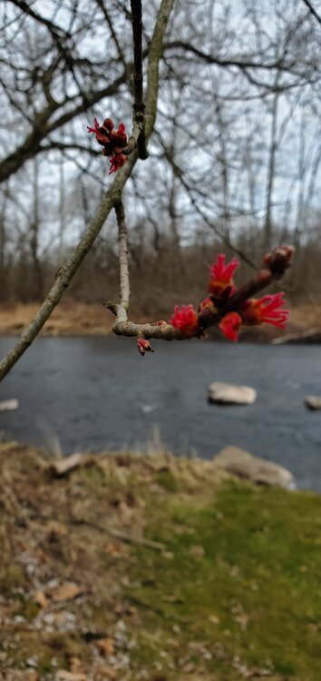
-
The Ides of March end of Winter 2023
mahantango#1 replied to paweather's topic in Upstate New York/Pennsylvania
It's March Madness, anything can happen. Even the big Dawgs can be silenced. -
The Ides of March end of Winter 2023
mahantango#1 replied to paweather's topic in Upstate New York/Pennsylvania
Then maybe when it finally breaks, our temps will soar to summer levels. -
The Ides of March end of Winter 2023
mahantango#1 replied to paweather's topic in Upstate New York/Pennsylvania
Will they beat Texas? -
The Ides of March end of Winter 2023
mahantango#1 replied to paweather's topic in Upstate New York/Pennsylvania
Brrr! I hope not, but I won't doubt it will happen. just when our minds turn to spring, winter doesn't want to leave. -
The Ides of March end of Winter 2023
mahantango#1 replied to paweather's topic in Upstate New York/Pennsylvania
It wont end till you return to Pa. -
The Ides of March end of Winter 2023
mahantango#1 replied to paweather's topic in Upstate New York/Pennsylvania
41 here, .04 in the rain bucket. -
The Ides of March end of Winter 2023
mahantango#1 replied to paweather's topic in Upstate New York/Pennsylvania
Say it isn't so -
The Ides of March end of Winter 2023
mahantango#1 replied to paweather's topic in Upstate New York/Pennsylvania
I'd bet on the latter. -
The Ides of March end of Winter 2023
mahantango#1 replied to paweather's topic in Upstate New York/Pennsylvania
Sick of these winds, enough already.


