

mahantango#1
-
Posts
5,079 -
Joined
-
Last visited
Content Type
Profiles
Blogs
Forums
American Weather
Media Demo
Store
Gallery
Posts posted by mahantango#1
-
-
82 was my high today.
-
6 minutes ago, Voyager said:
23 here. My tulips are toast. Too many frosty mornings since they first popped out of the ground.
25 was my low.
-
 1
1
-
-
34 minutes ago, Voyager said:
Not sure what happened, but CTP made a major correction overnight.
Maybe mahantango's exorcism gif did the trick...
Wednesday NightShowers likely and possibly a thunderstorm. Mostly cloudy, with a low around 44. Chance of precipitation is 60%.ThursdayA chance of showers. Mostly cloudy, with a high near 55. Chance of precipitation is 50%.Thursday NightShowers likely. Mostly cloudy, with a low around 40. Chance of precipitation is 60%.FridayShowers likely. Cloudy, with a high near 56. Chance of precipitation is 60%.Friday NightShowers likely. Cloudy, with a low around 46. Chance of precipitation is 60%.SaturdayA chance of showers. Cloudy, with a high near 61. Chance of precipitation is 50%.Now an exorcism should be done to correct the Tamaqua split.
-
 2
2
-
-
This current cold shot is probably the last REAL cold blast until late autumn.Now for the obtuse people in the back row you need to read that first sentence again carefully.yes of course between now and June 1 we are going to have cold fronts and cold or cool air masses. Obviously that is the case.What I am talking about in the first sentence are these cold blasts which knock us back down to the 20s at night and 40s to near 50 during the day. .All the data shows there is going to be a significant Ridge in the jet stream (sometimes extremely strong Ridge) that will be situated on the East Coast covering the eastern third of the country between now and April 15th. Any cold wants to come through will be weak and have no will push behind them.THAT BEING SAID REMEMBER SOIL TEMPS STILL HAVE TO WARM !!The old guideline zof waiting until aat least EASTER and preferably tax day...s till holds.
-
7 hours ago, Voyager said:
Sweet mother of God. It just won't end...
Wednesday NightRain showers likely before 2am, then a chance of rain and snow showers. Mostly cloudy, with a low around 37. Chance of precipitation is 60%.ThursdayA chance of rain and snow showers before 2pm, then a chance of rain showers. Mostly cloudy, with a high near 47. Chance of precipitation is 50%.Thursday NightRain showers, snow showers, and freezing rain likely. Mostly cloudy, with a low around 35. Chance of precipitation is 70%.FridayRain showers, snow showers, and freezing rain likely. Mostly cloudy, with a high near 47. Chance of precipitation is 60%.
-
1
-
-
25 this morning.
-
7 hours ago, canderson said:
Whatever happened to that radar in Lancaster county?
My son checked into this last year, I think my son said for the most part it's for the university. But if you have $$$ you can have access to it.
-
1
-
-
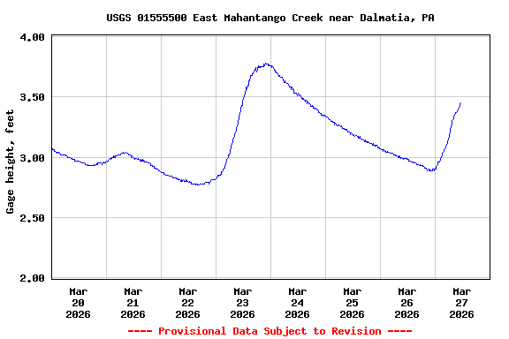
The creek by my place is running normal for this time of year.
-
1
-
-
12 minutes ago, pawatch said:
Picked up .67” off the storms. 45 degrees this morning and windy.
Not really sure I’m in agreement with the drought map.
It definitely has been wet here this month.
-
2
-
-
0.50 inDay0.69 inEvent1.55 inWeek6.48 inMonth8.33 inYearWell I'm over the 6 inch mark for rainfall for March,.
-
1
-
-
Andrea Michaels FOX43 PA’s latest Drought Monitor Update was released earlier this morning, with some notable improvements for portions of the Commonwealth!Northeast PA saw the most improvement—going from D0 (Abnormally Dry) conditions to nothing! This includes much of the Endless Mountains, the northern Poconos, and part of the Wyoming Valley.Some of the Middle Susquehanna River area saw improvements from D1 (Moderate Drought) to D0. This includes portions of Centre, Clinton, Snyder, Northumberland, and Union counties.Not much change unfortunately for South Central PA, but we’ve got some decent rain coming tonight! And there will be more opportunities next week too for needed rain. As long as this keeps up, we’ll get there. Patience is key. Climate conditions like this take time to fix if you’re not getting a single, big rain event.

-
78 was the high here today.
-
Another stellar day so far, while we wait for potential thunderstorms later.
-
 1
1
-
-
Dauphin County should be included in this if you look at SPC's map.

Hazardous Weather Outlook
National Weather Service State College PA
422 AM EDT Thu Mar 26 2026

PAZ006-011-012-018-019-025>028-034>037-041-045-046-049>052-056-063-
064-270830-
Potter-Cameron-Northern Clinton-Northern Centre-Southern Centre-
Blair-Huntingdon-Mifflin-Juniata-Bedford-Fulton-Franklin-Tioga-
Northern Lycoming-Southern Clinton-Southern Lycoming-Union-Snyder-
Montour-Northumberland-Perry-Cumberland-Adams-
422 AM EDT Thu Mar 26 2026

This Hazardous Weather Outlook is for central Pennsylvania.

.DAY ONE...Today and tonight.

Strong thunderstorms with heavy rainfall are possible this evening
into early tonight.
-
1
-
-
43 minutes ago, Voyager said:
Over the past few days, my Saturday high went from 44 to 42 to 41 to now 39.
Ridiculous...
Yea I took notice too that the high on Saturday is getting lower. Hang in there warmer days are ahead.
-
27 this morning.
-
-
22 minutes ago, Voyager said:
Today's mid 30's feels SO much better than yesterday's mid 30's.
Sunshine changes everything.
Yes I'm out shoveling stone to put in my lane came in now for lunch and I see the temperature is only 39. I thought it was warmer then that. That March sun is doing wonders. Today despite the temperature and virtually no wind is turning into a beautiful day. To me yesterday sucked with that cold and wind. Better days with heat and humidity are coming...sometime.
-
1
-
-
1 hour ago, Mount Joy Snowman said:
32 as I leave the house, may go lower. Happy Tuesday.
32 here.
-
1
-
-
3 hours ago, Voyager said:
Just to add insult to injury, to go along with the stupid 32 degree temperature, now it's snowing up in Hazleton too.
Today felt like January. Even though my temperature stayed at 38-39 that wind at times made it feel cold. I know my wife was coming home off 81 at the Hegins exit the temperature on her car showed 33 at the exit.
-
1
-
-
81 was my high yesterday ,exceeded my expectations.
-
1
-
-
It's been a wet March here. Wonder if I can exceed 6 inches for March?
0.85 inEvent0.85 inWeek5.78 inMonth7.63 inYear-
1
-
-
9 hours ago, Yardstickgozinya said:
The cell over Mclure has been a monster for some time. Still waiting on YouTube video and link confirmation from someone.
9 hours ago, Yardstickgozinya said:The cell over Mclure has been a monster for some time. Still waiting on YouTube video and link confirmation from someone.
There was a lot of hail with that one. Pictures and video on Facebook. That storm was on my doorstep but petered out before it got here, just got some rain from it. https://www.facebook.com/paweatherplus/posts/pfbid07E2DrsjgqnwyoajhFpzDx6xhx8KNtuj4kKqcSnogwR4sJhXSSLJoj5Z1x2JraZrxl
-
 1
1
-
-
Severe thunderstorm warning for my area quarter size hail is the threat.
Severe Thunderstorm Warning
PAC043-067-097-099-109-230100-
/O.NEW.KCTP.SV.W.0038.260323T0034Z-260323T0100Z/
BULLETIN - IMMEDIATE BROADCAST REQUESTED
Severe Thunderstorm Warning
National Weather Service State College PA
834 PM EDT Sun Mar 22 2026
The National Weather Service in State College PA has issued a
* Severe Thunderstorm Warning for...
Northwestern Dauphin County in south central Pennsylvania...
Northeastern Juniata County in central Pennsylvania...
Southwestern Northumberland County in central Pennsylvania...
Northeastern Perry County in south central Pennsylvania...
Snyder County in central Pennsylvania...
* Until 900 PM EDT.
* At 834 PM EDT, a severe thunderstorm was located over Beaver
Springs, moving east at 55 mph.
HAZARD...Quarter size hail.
SOURCE...Trained weather spotters.
IMPACT...Damage to vehicles is expected.
* Locations impacted include...
Millersburg, Newport, Middleburg, Mcalisterville, McClure, Port
Trevorton, Beaver Springs, Richfield, Mount Pleasant Mills,
Paxtonville, Troxelville, and New Buffalo.
PRECAUTIONARY/PREPAREDNESS ACTIONS...
Stay inside a well built structure and keep away from windows.
To report severe weather, contact your nearest law enforcement
agency. They will send your report to the National Weather Service
office in State College PA.
&&

Central PA Spring 2026 Discussion/Obs Thread
in Upstate New York/Pennsylvania
Posted