
ct_yankee
-
Posts
387 -
Joined
-
Last visited
Content Type
Profiles
Blogs
Forums
American Weather
Media Demo
Store
Gallery
Everything posted by ct_yankee
-
Incoming taint on radar... Sometimes the cold can fight it off, but... Current snow here in New Haven now has that heavy, almost-looks-like-rain appearance that usually indicates imminent changeover. So enjoy the thumpity while it lasts, at least on the coast.
-
Yeah, started as icy pingers here in New Haven but pretty quickly wetbulbed to all snow, which is now accumulating at a rather astonishing rate. Thinking those higher numbers from Upton could well verify if this keeps up for even a few more hours... The real deal, so far, and radar looking good.
-
Fall Banter, Observation and General Discussion 2018
ct_yankee replied to CapturedNature's topic in New England
Well, I was in fact aware of the potential today, albeit (I thought) really low probability... But I was totally unaware Upton radar was down and showing old imagery. Kept checking radar and seeing nothing... Finally caught on and looked at BOX, and was totally astounded. By that point the event was practically over with. Absolutely crazy day. -
Agreed, absolutely, and that's pretty much why I don't chase hurricanes, not unless they come right to me. But that's just me, others feel differently. For some, hurricanes are their one true passion, and chasing tornadoes might just be something to do during the off-season. I've known chasers like that. And of course some (like Josh, I believe) don't bother with tornadoes at all.
-
Except Tim's death and the various other stormchaser casualties haven't really changed the way people chase. When you chase a tornado, death is a possibility, every serious chaser knows this and always has known it. It's an inherently hazardous undertaking, not unlike, say, mountain climbing or sky diving. Someday a hurricane is probably going to kill a chaser, who can doubt it? But they take the risk knowingly, and if that's what they want to do, who are we to say it's wrong? We can debate ethics all day long, but it's never going to stop people from chasing, any more than Tim Samaras's death did. Any death is a tragedy, of course, but I know of no one who quit tornado chasing after El Reno. Disclosure, FWIW: I do enjoy chasing storms myself.
-
Yes, the razor's edge difference. Why does one day fizzle, and another go crazy? That is the key question. It often seems to me that shear doesn't behave as a linear continuum, but rather as a threshold, beyond which you get supercells and rotation, with nothing much happening until that threshold is reached. I've seen countless days out on the Plains where storms will go up and strengthen for hours without showing any signs of rotation, and then bam, suddenly every storm along the dryline will begin to spin and form a strong low-level meso, as if a switch was flipped... But it's almost as if we're not quite measuring the right things, because helicity values and the other parameters we look at don't seem to me to be able to predict exactly when and where that changeover to a supercellular regime occurs. Perhaps it's just that the numbers we look at via mesoanalysis and modeling aren't really reflecting the true state of the atmosphere, I don't know... But we're missing something, or we wouldn't keep getting surprised by these events. Not that Tuesday was a surprise, the SPC and others pretty much nailed it, but you know what I mean... Why was this event nailed, when so many others that looked pretty similar did not perform as expected?
-
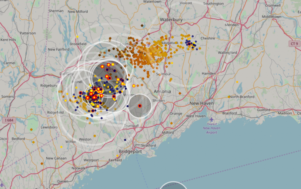
So... That supercell yesterday produced something like 4 tornadoes from just over the NY state line on out to Long Island, including one that tracked from New Canaan to Norwalk... And nobody comments? Yeah, I get it that some people just want to move on to winter, but damn... I expected a little more excitement.
-
Yep, very impressive cell. Hook wrapped all the way round, forming a doughnut-hole BWER for at least one scan. Still a strong storm, which might cycle again, but it's out in the Sound now, and it's getting dark...
-
This was always an iffy setup, that could have gone either way. The potential was there, but... The lack of a watch reflects the SPC's understanding that the day would probably underperform. I would expect a downgrade of the Slight with the next outlook issued.
-
Based on radar trends, I'm doubtful we'll see a watch - actually, make that I'm almost certain we won't. I'm not seeing anything much that impresses, and the trend this late in the day can only go downward with loss of insolation... This time of year, if it hasn't happened by 6pm, it's not happening.
-
Yeah, those are a bit more interesting than the rest, semi-discrete and definitely supercellular looking... Heading this way, too.
-
Kinda surprised SPC actually put out an MD for our area, usually they ignore these low but definitely not zero risk situations. LOL 5% watch probability: Areas affected...Portions of NJ into Long Island and southern Connecticut Concerning...Severe potential...Watch unlikely Valid 252138Z - 252345Z Probability of Watch Issuance...5 percent SUMMARY...Occasionally weakly rotating storms are expected over the next few hours. Overall severe threat is very low. DISCUSSION...Semi-discrete storms, currently anchored along a warm front, have occasionally showed transient, weak low to mid-level rotation across portions of central/eastern New Jersey into the NYC area and far southern Connecticut. Though lapse rates are quite poor throughout the troposphere (i.e 5-5.5 C/km), sfc-850 mb moisture is quite deep, contributing to MLCAPE of up to 1000 J/kg along/south of the front. While effective bulk shear values are rather modest given the marginally unstable atmosphere (30-40 knots across the discussion area), favorable low-level directional shear remains in place, with effective SRH values exceeding 250 m2/s2 over Long Island, with nearly 350 m2/s2 0-3km SRH noted by recent KOKX WSR-88D VWP data. Low-level flow is slightly more veered closer to PHL, with latest KDIX VWP data suggesting both 0-3km and 0-1km SRH exceeding 150 m2/s2. The favorable low-level shear, combined with the moist/marginally buoyant airmass, may promote semi-discrete storms in the area to continue weakly rotating on an occasional basis, particularly across portions of Long Island and southern Connnecticut, where storms may more favorably traverse the warm front and ingest available low-level streamwise vorticity. Still, given the marginally buoyant airmass and expected lackluster potential for stronger rotation, the severe threat appears quite low. ..Squitieri/Hart.. 09/25/2018
-
SPC: On Day 4 (Friday 9-21) however, an initial upper trough is forecast to be advancing quickly eastward across the Great Lakes and later the Northeast U.S., and adjacent eastern Canada. This trough will be accompanied by a seasonably strong cold front, progged to shift across the Northeast and Ohio Valley and shift off the New England coast by the beginning of Day 5. While instability along the length of the front -- particularly across New England -- will likely remain limited, strong westerly/west-southwesterly flow through a deep tropospheric layer may support potential for gusty/damaging winds, with a frontal line of convection. Thus, a severe risk area is being included Day 4, from parts of the Midwest/Ohio Valley northeastward into New England.
-
No kidding! I think there were 4 or 5 CGs that must of hit within a block of me (right downtown) in the space of a couple minutes... Including one that got the building across the street while I watched.
-
Have to agree, constant lightning...
-
Hmmm, nice. Score one for James?
-
And we have an appropriately meh MD out. hard to get exited about "a few marginal supercell structures": Mesoscale Discussion 1307 NWS Storm Prediction Center Norman OK 0142 PM CDT Fri Aug 17 2018 Areas affected...Portions of central/eastern NY/PA...northern NJ...southern VT...and western MA/CT Concerning...Severe potential...Watch possible Valid 171842Z - 172115Z Probability of Watch Issuance...60 percent SUMMARY...An isolated threat for strong to locally damaging winds should continue to increase this afternoon as thunderstorms develop and move eastward. A Severe Thunderstorm Watch may be needed within the next couple of hours. DISCUSSION...Airmass recovery is well underway across parts of eastern NY/PA behind morning showers and thunderstorms associated with a low-amplitude lead shortwave trough over New England as of 1830Z. Continued diurnal heating across this region given cloud breaks noted on visible satellite imagery will allow surface temperatures to generally reach into the mid to upper 80s, and plentiful low-level moisture will contribute to MLCAPE around 1000-2000 J/kg along and south of a warm front. However, poor mid-level lapse rates noted on 12Z soundings from ALB, BUF, and PIT will likely temper even greater instability this afternoon. The 18Z sounding from ALB modified for current conditions shows some steepening of low-level lapse rates, and this process should continue with eastward extent across western MA/CT and southern VT as the surface warm front lifts northward. Recent VWPs from BGM, CCX, and ENX show low-level southerly winds veering quickly to southwesterly in the 0-6 km AGL layer, although the magnitude of these winds remain generally limited (at or below 30-35 kt). Even so, around 25-35 of resultant effective bulk shear should prove adequate for scattered thunderstorms organizing into multicell clusters. This convection will mainly pose an isolated strong to damaging wind threat this afternoon and early evening given the steepening low-level lapse rates and modestly strengthening low to mid-level flow. A few marginal supercell structures with some hail threat may also occur with south/westward extent where instability is stronger. A brief tornado cannot be completely ruled out along the warm front given the locally backed near-surface winds locally enhancing 0-1 km SRH. Given the expected increase in thunderstorm coverage and intensity over the next couple of hours, a Severe Thunderstorm Watch may be needed to address this threat. ..Gleason/Dial.. 08/17/2018
-
CAMs were always (well, since last night) showing basically two waves of storms, one around 19z which has already materialized, and then another after 0z (for some models well after) so it's playing out the way it was modeled, so far... That said, the good shear seems to be hanging back west well behind this first line of storms, and who knows how much instability will be left later on, so... As always, we wait, and we'll see. It is what it is. I've learned never to get exited about these kind of setups.
-
This. The parameters were pretty good yesterday also, but... No storms.
-
The feature Tip (presumably) and I were looking at is clearly a reflection, it goes right into the road in this second pic. Still, it's a nice pic of a nice storm, just no tornado.
-
It's not a gustnado. I've seen plenty and they don't look like that, they don't connect with the cloud base, most are just funnel-less dust whirls. That said, the photo looks very sketchy if it's purporting to show a tornado. I suppose it could be, but the ruler-straight "funnel" looks more like a reflection of some kind to me. Would need more info to make a real judgement, such as where and exactly when the pic was taken. FWIW, there were indeed a couple of waterspouts in Jersey yesterday, pics are available online, for instance: https://patch.com/new-jersey/barnegat-manahawkin/incredible-video-pictures-waterspout-lbi
-
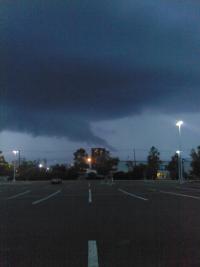
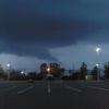
Man I am so pissed at myself... When the base of that cell first appeared over the buildings of New Haven it had fantastic structure, looked like a meso from the plains, classic... But I have a brand new phone with a new (and much nicer) camera - that apparently I have no idea how to use! I fumbled around for about 15 minutes trying to get the damned thing to use the outward camera rather than the one for selfies... By the time I figured it out the structure I wanted to photograph was gone, the meso fell completely apart, not even a decent shelf to show for my troubles... Really impressive, but then totally garden variety by the time I got the shot... Damn it. Cell is not even remotely severe now. Friggin' technology, smartphones, who needs 'em... Bah! My crappy old camera would have gotten the pic easily. Ah well...
-
That storm in southwest CT is exploding. I can see the top of it from here. Don't think I've ever seen so much lightning on lightningmaps, it's continuous - more even than those storms yesterday.
-
Hmm... I have Grazulis' 30 page "New England Tornadoes" pamphlet, wonder if that's worth anything? Actually I'm sure it isn't, I got it for free way back when I bought the Tornado Video Classic tapes, but it's actually very useful, has entries on every New England tornado going all the way back to the 1700s (it stops at 2000 when it was written), plus some track maps which are pretty cool. I would love to have the big book as well, I remember almost buying it, but it was just a bit more than I was willing to spend... Too bad, sounds like it would actually have been a pretty good investment.
-
Worse than we bite?

