ct_yankee
-
Posts
389 -
Joined
-
Last visited
Content Type
Profiles
Blogs
Forums
American Weather
Media Demo
Store
Gallery
Everything posted by ct_yankee
-
Hmm... I have Grazulis' 30 page "New England Tornadoes" pamphlet, wonder if that's worth anything? Actually I'm sure it isn't, I got it for free way back when I bought the Tornado Video Classic tapes, but it's actually very useful, has entries on every New England tornado going all the way back to the 1700s (it stops at 2000 when it was written), plus some track maps which are pretty cool. I would love to have the big book as well, I remember almost buying it, but it was just a bit more than I was willing to spend... Too bad, sounds like it would actually have been a pretty good investment.
-
Worse than we bite?
-
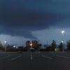
I have yet to see any persuasive video of any of the May 15th tornadoes. This one was just as rain-wrapped as those were if not more so, so there might not be any video. We don't often get the photogenic kind of tornado around here.
-
No Slight as yet, but they did highlight that area for Marginal wind/tor risk. Still might get upgrade to Slight in the morning, definitely possible... But I think I agree with leaving things at Marginal til morning, it avoids any chance of having to do a messy backtrack/downgrade if tomorrow starts looking, well, marginal again. Personally I've hardly had the time tonight to look at models for myself, so I must defer to your and their better judgement... We'll see what tomorrow brings. We don't often get these kind of multiple-day streaks of successive severe weather threats here in southern NE, but this was actually hinted at quite well by the GFS well over a week ago. I remember thinking I was seeing an awful lot of chances for Northeast severe showing up, most of them at the very end of its range, past the time we normally consider the Goofus to be useful, but damned if that hasn't panned out as advertised... Maybe not in the specifics, but definitely as a trend and pattern. Bring it on!
-
Mesoscale Discussion 1225 NWS Storm Prediction Center Norman OK 0315 PM CDT Fri Aug 03 2018 Areas affected...Extreme southeastern NY/western MA to southeastern NH and extreme southern ME Concerning...Severe potential...Watch possible Valid 032015Z - 032115Z Probability of Watch Issuance...40 percent SUMMARY...Occasional damaging gusts will remain possible with supercells along a front/differential heating boundary, and with the merging clusters spreading northeastward from southeastern NY. The severe threat duration should be the next 2-3 hours. DISCUSSION...A small cluster of storms with supercell structures is spreading east-northeastward across southeastern NH, close to a differential heating zone/weak stalled front. The storms are along the north edge of a corridor of moderate buoyancy, and the southern fringe of the stronger midlevel flow. There will be a narrow window of opportunity for the storms to persist along the front, until weakening late this afternoon/evening as the storms cross into the remnant sea breeze air mass just inland from the ME coast. Farther southwest, a loosely organized cluster of storms is spreading northeastward from extreme southeastern NY toward northwestern CT and western MA. Additional storm mergers are expected as the outflow with the cluster intersects the composite front/outflow/differential heating zone. The strongest storms have produced some tree damage and a measured 52 mph gust at the Beacon mesonet site in southeastern NY. The severe threat should be confined to the narrow zone along the front for the next 2-3 hours, though the need for a watch is not clear. ..Thompson.. 08/03/2018
-
New MD with 40% watch prob. Bit little bit late, but better late than never
-
That NAM NEST helicity track that Wiz posted earlier seems to have really nailed it perfectly.
-
Assuming a tornado is confirmed, it's very typical of the area that the WSR-88D's couldn't really resolve the action very well... That's a classic Southern New England type spin-up, flying almost literally "under the radar" as far as the 88Ds are concerned.
-
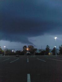
Queens, wow, wasn't expecting that! I wasn't even watching the radar after the daylight stuff moved thru... Thought it was all over. Kinda stunned, actually... Completely missed it. That said, there were small-scale spin-ups along the southern fringe of the day's convection all along, Ansonia was just the most prominent of several examples... Assumed there was a boundary down there along the coast, probably seabreeze related... So I shouldn't really be surprised. Interesting stuff!
-
Maybe a little spin up of some kind down near Ansonia, tight persistent couplet and hook, but small, you almost need the super-res radar to see it...
-
Now sure THAT deserves a warning...
-
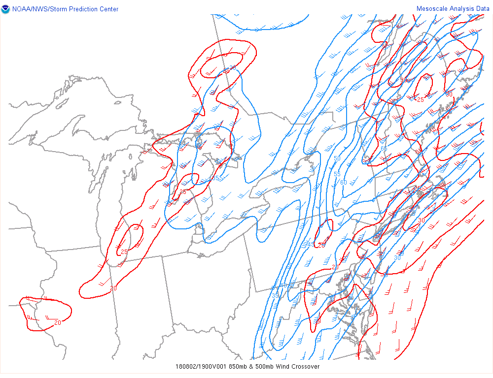
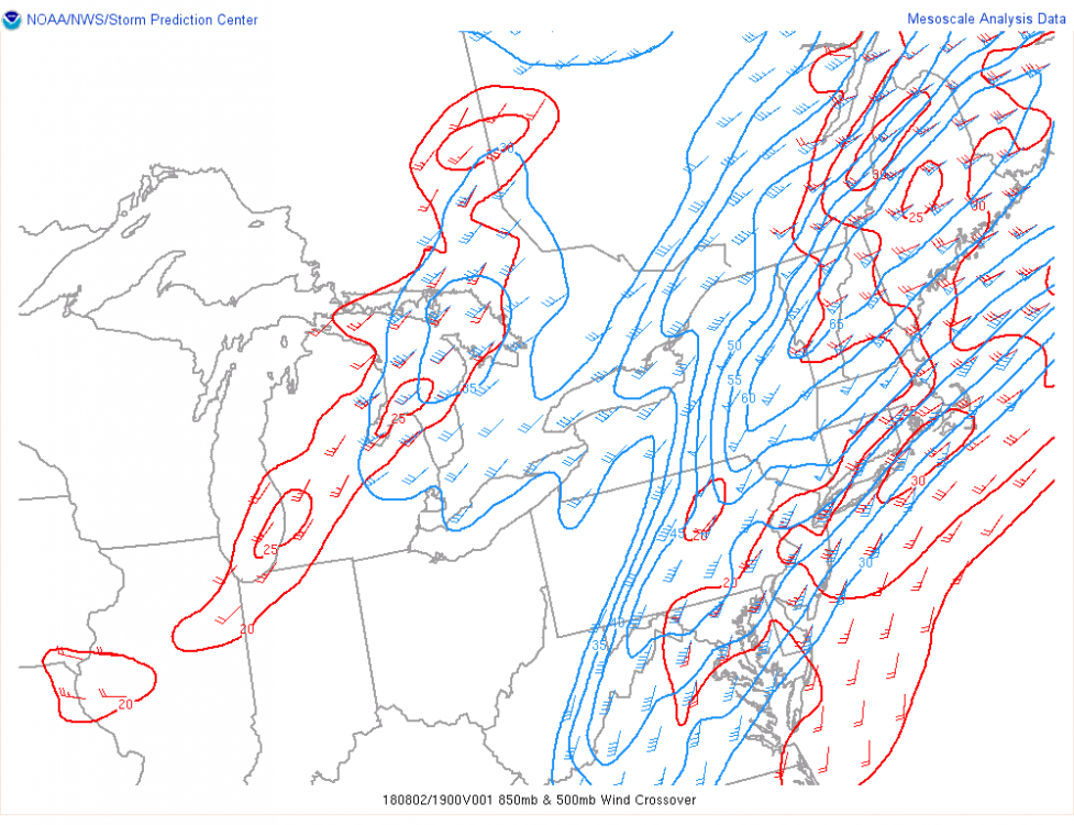
But winds are turning the wrong way with height:
-
Although there's bulk shear, SR helicity is meager or lacking entirely. Not a good day for anything really interesting.
-
Lightning activity just stopped dead as soon as the storm passed New Haven... Was going pretty good before that.
-
Wrote it off... And there it is! Gotta love New England. Current radar is pretty much exactly what the HRRR was showing late last night, but then forgot about as of this morning.
-
Late last night at 2:00 am the HRRR and some other meso-models were clearly indicating isolated supercell activity along the CT coast and even Long Island around the 22z time frame... That's all gone now - no strong cells or helicity swaths of note in southern CT anymore, the show has moved northwest... Congrats POU indeed, although there's precious little even up there now. Anyway, don't feel so bad about having to sit this one out, it's looking like any spin-up will be transient, weak, and not very close to me.
-
Figures. My car is out of commission so I can't chase this one even if something does happen - which it will because I can't chase. So it goes.
-
True, and I've always thought of what I saw as one, since it met the definition. But it wasn't really a landspout, and there was no mesocyclone present that I know of, and it wasn't really a gustnado either. So, are there other types of tornadoes? I think with these transitory spin-ups maybe there are. Lots of stuff out there we haven't yet classified.
-
These tiny spin-ups don't necessarily fall into any particular category. Many years ago near East Haven I watched a small finger of condensation on the front edge of an approaching storm that was all the way in contact with the ground, but wasn't moving and definitely wasn't rotating, not at first. But as I watched, it gradually started to spin, from the top down - slowly at first, but then faster and faster until it eventually looked like a genuine tornado, spinning away like crazy until I lost it in the rain... What would you call something like that? This thing could be similar, who knows.
-
That is like the weakest tornado I've ever seen! And that includes that momentary spin-up in the NH mountains a few weeks ago. Still, it's very cool, and pretty unexpected... Except of course by Ryan who predicted it. Nice.
-
Your right, that hodo is actually not all that bad for NE. Where is this sounding for?
-
Roger Hill has been streaming that cyclic supercell on the MT/SD border, at least 4 tornadoes with it so far... The last and possibly still ongoing one was large and looked violent
-
I'd be very surprised if anything really severe made it to HFD, the boundary of marine tainted air had moved almost to the northwest corner of the state earlier, but you never know. Down here there's no chance at all... Cape is gone.
-
You can see the storm pass on the loon cam by setting the time slider back, apparently everything was recorded... Semi-cool looking, I guess, but little in the way of obvious rotation.
-
I definitely saw that feature, but from a great distance while driving in heavy traffic - couldn't get a clear photo of it. I did wonder briefly if it was a funnel, but it looked more like a wall-cloud type deal or even an outflow feature from where I was.