
ct_yankee
-
Posts
389 -
Joined
-
Last visited
Content Type
Profiles
Blogs
Forums
American Weather
Media Demo
Store
Gallery
Posts posted by ct_yankee
-
-
So would one expect to see a TDS with a strong tornadic waterspout? Not really any debris as such, just water, so I would guess maybe not... Anyone know?
-
Man that velocity sig in the sound is nuts. Its more than just a meso, although it no doubt contains one... But I'll be damned if I know what it actually is or represents, it goes all the way across the sound...
-
Absolutely crazy BLAM! of thunder a minute ago in HVN, was like a cannon shot or explosive, did not think it was thunder at first...
-
Considering mesoanalysis is showing close to zero CAPE, those are some pretty good looking cells developing in S. CT...
-
5 minutes ago, DotRat_Wx said:
Ship has sailed for South coast west of ct/RI border
Yeah was really only considering CT, where the conditions seem to still be somewhat conducive, but you're right, nothing further is expected.
-
Yeah it all looks pretty meh, but... The atmosphere south of the front is still surprisingly juicy and apparently getting slightly more so with time. For that matter the front itself is seemingly being held back or even actively pushed north in places by the strong LLJ.
It would be rather ironic if DIT's predictions of an active severe night come to pass after all. Not that I expect that, but given current mesoanalysis one couldn't completely rule it out either...
-
6 minutes ago, klw said:
Storms here now breaking our dry spell at 34 hours
Congrats. Watching that from a distance from here in Bradford. Not nearly as organized as the one up here yesterday, but yeah its a thunderstorm, I'm sure you'll take it...
-
Currently observing a beautiful little supercell passing just north of Bradford VT where I am staying. Got some decent cellphone video of the storm structure with the setting sun behind it, really nice for New England. Am not at home so may be difficult to edit and post any vid caps right now, but nice, really nice, and kinda unexpected. Some cool CGs with the cell, one of which I have video of. Very pleased!
-
 5
5
-
-
"line just died when it hit New Haven"
Boy am I used to that! I was just getting ready to drive to VT from HVN as that storm matured over Hamden, looked really nice, lots of staccato thunder... But I knew what would likely happen, and I just drove away from it. Didn't even look at what happened to it until now. Yeah, went as expected, although nice that Hamden got that hail. Agree about the flags today. On to the next one, indeed.
Edit: its frickin cold up here in VT!
-
1
-
-
Well, those storms did die before they got to me, but then a small cell blew up right on top of the city, with plenty of very close lightning hits... I'll take it.
-
Lightning ramped way down... Crap, it's probably gonna die before it gets to me. So close, and yet so far away...
-
Bring it. Haven't heard so much as a rumble of thunder these past 2 days here in New Haven, so yeah, I'll take a 2am thunderstorm, definitely.
-
3 minutes ago, DotRat_Wx said:
HOLY SHIT it became a monster in just a few frames!
It hit the outflow boundary from previous storms head on, that's what blew it up like that.
-
1 minute ago, CT Rain said:
I think there was some side lobe contamination there. The data looked a bit noisy.
I actually wondered about that at the time, but was convinced by the fact that reflectivity started to show a cyclonic curving hook-ish look to the cell right after the couplet showed up. Admittedly that coulda just been coincidence, I suppose...
-
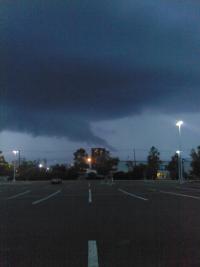
Spin up of some kind in Windsor looks like
-
4 hours ago, weatherwiz said:
Tomorrow actually looks better than today I think for severe and some hints at another weak EML (which there is one too just south of us today)
Interesting you say that about tomorrow being the better day, last night I almost posted to that effect... But I'm just not confident enough in my forecasting abilities, especially on this board with so many truly knowledgeable people, so I never hit the submit button. But yeah as of late last night I thought Wed could be the better day, although storms probably won't be as widespread as today - but that can be a good thing from a chasing perspective. I'll see how today plays out, then take another look at tomorrow.
-
2
-
-
Yeah this was one of the few times a NE event was well forecasted, IIRC SPC had a 10% tor in that region, and everything played out perfectly for once. Personally nailed the forecast too, I figured storms would initiate upstate NY moving from the hudson river/albany area towards Springfield, I remember trying hard to convince my friend who really isn't into this stuff to go up there, with an initial target just west of Springfield, definitely would have seen it. But his wife said something like "you're really going to drive all the way to MA just to look at some rain?" and he begged off. Should have gone alone, still bothers me that I didn't, but that's chasing in New England: you probably won't see anything, but you definitely won't if you don't go. Can't believe its been 10 years already.
-
Beautiful supercell on radar ENE of Denver but must be nothing out that way, at least not in the way of cell service, since I can't find a single livestream that's active...
Edit: Matt Grantham's stream is back on for that cell (heh, for a second)
-
What a beautiful storm! Has produced at least 3 photogenic cones so far and some dusty spinups, streaming has been intermittent so total could be higher than that. Impressive stuff!
-
1
-
-
Southern CT def gettin smoked. Seems like most of our major snowstorms these last few years have tended to deliver the majority of the snow in quick bursts of extreme accumulation, like that Dec. storm where we picked up the better part of a foot mostly in just a couple hours... But this one, this has just been solid very heavy snow/near blizzard from the moment I woke up today (which admittedly was close to noon) and it's still going strong as ever right now, with no letup. That is indeed impressive, and its definitely been a minute since we've seen one like this.
-
1
-
-
4 minutes ago, DotRat_Wx said:
Somehow this thread went over to huffing drugs
As they do...
-
Getting the goods now in downtown New Haven for sure. Too windy to say how many inches might be on the ground, but there's a certified crap-ton in the air...
-
Seems to be regenerating its CDO at a healthy pace, it certainly looks like its strengthening. I suspect if this same exact storm were in this same exact place but being born for the first time there would be quite a bit of interest, at the very least some wild wishcasting posts. Instead, the board seems to be burnt out on ETA. I suspect a lot of people just wish it would go away at this point. I admit that right now it doesn't seem to have a very bright future, but still...
-
3
-
-
2 hours ago, It's Always Sunny said:
Yeah not so sure about the criteria. I've always used 240 miles as my benchmark. Another thing I noticed was dew points were only in the 50's with this serial derecho I wonder if that classifies it as a low dew point derecho. Does anyone know the threshold on that?
According to this paper: https://www.spc.noaa.gov/publications/corfidi/ldd_2006.pdf it's below 50 and/or pwat<.5:
"More rarely, high-wind-producing MCSs occur in en-vironments of very limited moisture, with surface dew-points at or below 50°F (10°C) and/or precipitable wa-ter less than 0.5 in. (1.25 cm). Systems forming in suchenvironments, herein referred to as low-dewpoint dere-chos (LDDs), have been observed throughout much ofthe year and over much of the United States from theGreat Basin to the East Coast. "
Personally I would guess that this event might be classified as a hybrid serial/low-dewpoint derecho. If that is a thing.
-
1
-
Ghost of Ida Impacts Thread
in New England
Posted