
ct_yankee
-
Posts
400 -
Joined
-
Last visited
Content Type
Profiles
Blogs
Forums
American Weather
Media Demo
Store
Gallery
Posts posted by ct_yankee
-
-
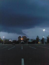
Did they extend the watch and then trim it back again? I could have sworn I saw it covering almost all of CT a few minutes ago but now it only covers the northwestern corner.
-
This is very underwhelming. I don't get the extended watch either.
Good old New England, never disappoints, which is to say it almost always does. I always have zero expectation for these events, and once in a great while I'm pleasantly surprised. Not today, tho. So it goes.
Edit: and we might have a spin up in VT as I post this. Yep, that figures.
-
 2
2
-
-
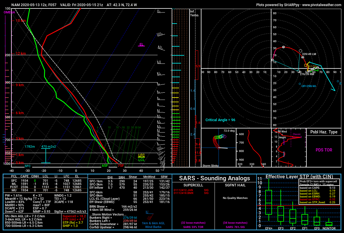
Nam sounding for central MA friday 21z:

-
 1
1
-
-
9 minutes ago, mgerb said:
For everyone ragging on LCH, I noticed some problems with warnings not displaying in RadarScope this evening. For instance, the post above questions LCH's lack of warning around 9:25 or 9:30 PM, but there was a warning issued back at 9:04 PM. I thing something screwy was happening with the warning polygons (at least in RadarScope).
I also wondered if there wasn't something screwy with radarscope so I looked elsewhere, specifically at SPC mesoanalysis, but there was no warning box there either. If there was a glitch I think it goes further than just radarscope.
-
53 minutes ago, The 4 Seasons said:
Latest OKX maps. I can agree with the inland numbers around 5-6". But HVN gets more than 2 thats for sure. They are already close that.
Yeah, I was just driving home from Stony Creek about an hour ago and it seemed like we had at least a couple of inches already... The intensity of the snow has tapered since then, but it's still snowing and I agree the total's gonna be well over 2 inches... But does it really matter? Whether it's 2, or 4, or even 6, its all gonna get washed away by the rain, at least it will here in New Haven.
-
3 hours ago, Ginx snewx said:
Download sci go app its free for the first 2 episodes
Near as I can tell by googling, it still requires a sign-in, it's marketed as "free with your TV provider". I don't see anything about free episodes without a sign-in, do you have a link that says different?
Note: I do not want to sign up for any free trials that require giving up a credit card number in advance. Been burned before doing that.
-
2 hours ago, wxeyeNH said:
For those of you that are interested, you can watch the first episode of Hurricane Man. I thought the episode which featured Hurricane Michael was well done. I am not sure if this link will work if you don't use facebook. https://l.facebook.com/l.php?u=https%3A%2F%2Fbit.ly%2F317ye9a
Won't work for those of us who have either cut the cord or, like me, never had any cable or any other "TV provider". Would love to see Josh's show, but I get turned down with a message saying "your xfinity service does not include this program". I only use them for internet and mobile, which apparently isn't enough.
-
4 hours ago, f2tornado said:
This will not be a popular opinion here. The BMX tweet would have been the end of it however ABC Nightly News turned the tweet into a hit piece on the President in an effort to stick him with a gaff. The President then lashed out at the reporter and the pile on began. I have rarely seen this kind of media passion to turn a nontroversy into a controversy.
Consider the following published from BMX seven years ago
AREA FORECAST DISCUSSION
NATIONAL WEATHER SERVICE BIRMINGHAM AL
626 PM CDT THU AUG 23 2012

TROPICAL SYSTEMS ARE NEVER BORING OR EASY TO FORECAST AS ISAAC
CONTINUES TO CHALLENGE.
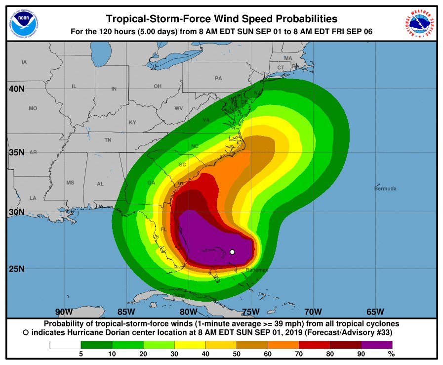
Kudos to the BMX forecaster who had the utmost confidence to publish an effective 0% forecast "no impacts... felt across Alabama" via Twitter in spite of the same office previously noting forecast difficulty with tropical systems. This conflicted, albeit slightly, with the NHC published probability distribution of TS winds covering a portion of AL. Further, it was somewhat inconsistent with the morning 9/1 Tallahassee AFD which covers southeast AL and stated, "The latest forecast for Hurricane Dorian from the National Hurricane Center continues to keep it east of the local area. While we still shouldn't let our guard completely down, the chance of impactful weather from Dorian occurring in our forecast area remains low".
BMX should be no stranger to forecast uncertainty. Take a look at the forecast cone for Hurricane Isaac (2012) that at one time was nearly centered over BMX. In fact, the entire state of Alabama was enveloped within the cone before none of the state was in the cone. It should be noted, even though the entire state of Alabama was outside the forecast cone toward landfall, the Mobile area did experience some TS force gusts and impact from surge. The cone only represents the storm center forecast track. This is why NHC storm wind probabilities are smeared well outside the cone with time and why forecasters should be cautious speaking in absolute terms, particularly when the average error for a tropical system is about 200 miles on day 5.
Oh FFS, President Sharpie didn't just say that there was a chance of Alabama getting hit, he specifically said they were going to be hit "harder than expected", something no weather map or model was indicating at the time, in fact the trend was exactly the opposite. After a presidential statement like that, BMX was absolutely correct in setting the record straight. And you know it.
-
3
-
 4
4
-
-
So, does anybody still believe that the NWS/NOAA would never ever let politics dictate a weather statement, as was being professed on this board a few days ago?
To be clear, I didn't think so then... But now? It's just f'n pathetic.
-
2
-
-
4 minutes ago, Baroclinic Zone said:
Also, studies seem to show that people who swear, are more intelligent.
https://www.sciencealert.com/swearing-is-a-sign-of-more-intelligence-not-less-say-scientists
Fookin' A!!!
-
1
-
1
-
-
12 minutes ago, TennTradition said:
Wait - are some arguing that’s real? It had to be a rendering based on an assumed sea level change, no? I assume it’s turned into a running joke?
Some people appeared to be arguing it's real... But it's so hard to tell on here who's trolling and who's being serious...
-
Regarding that "satellite image", it is indeed sort of a fake. If you look closely you can see that the water is just basically photoshopped (figuratively speaking) into the image, the waves are not breaking where they should be, etc, etc. What they did is use a sat to figure out where the new water (new coastline?) currently is and then made an image that looks like a photo but actually isn't. It's an "artist's conception" kind of deal except the artist was probably a computer algorithm and the position of the water is probably spot on. It is NOT a satellite photograph! Ya gotta be careful these days about what's real and what isn't.
-
I've been thinking about the fact that there's been no sign of an ERC with Dorian. Everybody's been looking for that all day, but there's been nothing. Very weird.
I'm thinking somewhere there's a painting of the hurricane, a picture, as it were... And if you look very closely and carefully at the picture of Dorian, there you will see the Eyewall Replacement Cycles. Only on the picture, while Dorian the storm sails on blissfully and forever unchanging.
Well, it's a theory. I do like the name.
-
Still all snow in HVN, and still insanely heavy, the sleet looks to be confined to southeast portion of the state...
-
This band is easily the fastest accumulating snow I've seen since Nemo. There's a guy shoveling the sidewalk across the street from me and you could literally watch the pavement turn white again behind him... Crazy stuff. Haven't seen any true sleet here in HVN, not yet, although the heavy wet snow does have a kind of "sleety" look to it at times... If we can manage to hold off the taint thru the morning there'll be some insane totals in this region come dawn.
N IL Area Severe threat 5-23
in Lakes/Ohio Valley
Posted
It's making my brain hurt trying to figure out which way that should be rotating.