
ct_yankee
-
Posts
387 -
Joined
-
Last visited
Content Type
Profiles
Blogs
Forums
American Weather
Media Demo
Store
Gallery
Posts posted by ct_yankee
-
-
The cell clearly cycled a few times, not surprised there were multiple reports. Would love to know what happened out in the Sound, though. That supercell looked even better on radar... Guess we'll never know, unless someone on a boat got in a really lucky shot.
-
 1
1
-
-
Radar tightened up on the RI cell, may be about to do something again - if indeed it already produced.
-
4 minutes ago, Hoth said:
Yeah that thing is sweet!
It was riding a fine-line boundary of some kind when it was at its best, either outflow from earlier convection or seabreeze of some kind, barely discernable on super res radar.
-
The cell in the Sound looks incredible now, might even be producing. Would there be a CC drop over water? Never thought to ask about that before...
-
8 minutes ago, Modfan2 said:
Does anyone else see rotation in e ct?
Some, yeah, probably mid-level, the cell is pretty far from the radar(s). That cell in LI Sound south of New Haven also showing signs of some rotation.
Edit: the cell south of me just got a waterspout warning
-
3 minutes ago, weatherwiz said:
Some impressive mesos within those storms.
Agreed, but when I looked about an hour ago almost none of the models were showing the activity making it very deep into CT - which is why they only have the watch to about Bridgeport. But of course even the best models are sometimes wrong, so we will see. It does look impressive now, tho.
-
What a waste of decent ML lapse rates, you just don't see 7 or greater over CT very often in the summer. The few soundings I looked had a hint of an EML, which explains the LRs but it was completely wasted without any strong forcing and with mediocre dews, and shear wasn't great either... When oh when will Southern CT get another genuine severe day? Don't answer that, I'm well aware of expectations, the question was merely rhetorical.
-
Have never seen high 70sdews offshore in July before. That's gotta count for something.
-
Didn't even get much rain in Hvn, let alone lightning, we were about the only remaining area with instability and LL shear unaffected by outflow but as expected, not even a storm really. From what I looked at last night the next one on Sat had more potential, but no doubt that will fail too. Stoopid hot and humid though, didn't even wanna walk to my car for the chase, if one was to had. Sigh...
-
4 minutes ago, Hoth said:
Good storm. Some close lightning and torrential rain. Maybe hail mixed in?
Agreed. Was not expecting much of anything ahead of the line/CF but those are some nice little cells.
-
1
-
-
This storm's entire life has been filled with weirdness, mesocyclonically speaking. The cell splitting in two and then having the two mesos dance the Fujiwara before actually recombining back to a single cell is just par for the course, and also totally insane. Watched the whole development on radar from far far away, unfortunately... But what a storm - simply amazing evolution.
-
1
-
-
Also for tomorrow SNE tor risk has been upgraded:

-
1
-
-

One big hatched area now... That's a huge area for a 15% hatched tor risk.
.
-
3 hours ago, Whineminster said:
The way to do it. From 30" snow to severe in 2 weeks. Perfect.
This is the way.
-
Been watching this one for a few days, the GFS has been relatively consistent with a potential severe event... In fact I almost asked about Saturday in the other thread, but thankfully controlled that impulse. I mean sure the numbers look good, at the moment - or at least they still did last night when I looked at it in detail. But it's Southern New England (sigh), and I've learned the hard way never to get my hopes up. But yeah, by all means lets start a thread and watch what happens. It couldn't hurt... Could it?
-
11 minutes ago, Hoth said:
Ba-boom! Some excellent CGs in downtown New Haven this morning.
Indeed there were... Woke me right the (expletive deleted) up instantly, can tell you that. Every now and then we seem to get these morning surprises, and they are often unsually strong, especially considering the general lack of instability and this hour of the day.... Very loud and annoying if one is still in bed.
-
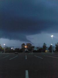
Nice isolated storm to my west near Monroe CT, starting to look interesting... If it continues to improve may have to go have a look, despite the inevitable traffic... Been very few opportunities to chase locally this summer. Pretty much none, in fact.
-
13 minutes ago, Typhoon Tip said:

Who claimed they witnessed 6.67 CG discharges per second …?I don’t believe there are any natural physical processes on Earth capable of creating that kind of electrodynamic power … even if it were physically possible for human eye to parse out what’s going on and when, which is also not possible at ~ 7 bolts/S
I have personally seen storms that must have approached that out west (Kansas, Nebraska, etc), with certainly more then 7 discharges/sec, sometimes the whole updraft is alive with multiple constant lightnings... But not all are CGs, its mostly intracloud, 7 CGs/sec is pushing it, and in any event you need really good ML lapse rates for that kind of thing and we never ever get that here. But I suspect its possible elsewhere.
-
1
-
-
17 minutes ago, Torch Tiger said:
I think that was a moderate risk that day, and almost nothing developed. Cape was like 1000 j/kg, skinny though, ml lapse rates were horrid and cloud cover prevented much destabilization.
Except for the mod risk, that description is almost generic for us... Par for the course.
-
Definitely some breaks in the clouds behind that stuff in the sound, at least there are here in HVN. Hints of blue sky... Every little hole in the cloud cover can make a difference on a day like today.
-
Wow that guy was incredibly lucky the tornado was relatively weak, it basically went right over him! If you see a tornado that is obviously coming right for you when you're in your car, probably a good idea to try to get out of the way. That could have gone so much worse.
-
1
-
-
Man, I was right in Branford where the tornado supposedly was. I was at the Stop and Shop at exit 56, watching the sky. I saw some very cool lightning, a few darkish looking clouds, and absolutely no sign of any tornado. No high winds, no lowerings, nothing. I was right there, and saw essentially nothing. Unbelievable. Not doubting it happened, mind you, just disgusted that I could be so close and completely miss everything. I mean I just happened to be in almost the perfect spot pretty much by chance, and stil... I got Nada. Honestly, I didn't even suspect any severe actually happened in the area until I got home and read this thread.
(sigh...)
-
 1
1
-
-
New MD
Mesoscale Discussion 1679
   NWS Storm Prediction Center Norman OK
   1020 PM CDT Wed Sep 01 2021

   Areas affected...far northern New Jersey...southern New York...Long
   Island...and far southern New England

   Concerning...Tornado Watch 484...

   Valid 020320Z - 020445Z

   The severe weather threat for Tornado Watch 484 continues.

   SUMMARY...Thunderstorms currently moving across Long Island and
   southern New England will continue to pose a risk of strong
   thunderstorm winds and a couple of tornadoes. A new watch downstream
   of Tornado Watch #484 will be issued.

   DISCUSSION...The remnant low-level circulation of post-tropical
   cyclone Ida continues to move northeast toward the greater New York
   City area. The low-level wind field continues to advect a very warm,
   moist air northward into southern New England as a warm front slowly
   lifts north across Long Island. Time-evolution VAD winds from Upton,
   NY, (KOKX) suggests that the warm front is very near or just north
   of the radar. Additionally, the time evolution of KOKX's VAD winds
   indicates a strengthening wind field that veers with height, leading
   to 0-1 kilometer SRH in excess of 800 m2/s2.

   As thunderstorms continue to move east from northern New
   Jersey/southern New York, across Long Island and southern New
   England, they will interact with this extremely favorable kinematic
   environment. The result is a continued potential for a couple of
   tornadoes and strong thunderstorm winds along and south of the warm
   front. The most appreciable tornado risk will be in the vicinity of
   this lifting warm front, but how far north it lifts before being
   overtaken by the approaching thunderstorms is uncertain. Portions o
   coastal and near-coastal areas downstream from Tornado Watch #484
   across southern New England will need a new tornado watch.

   ..Marsh.. 09/02/2021

   ...Please see www.spc.noaa.gov for graphic product...
-
1
-
-
So would one expect to see a TDS with a strong tornadic waterspout? Not really any debris as such, just water, so I would guess maybe not... Anyone know?
May 2024 Discussion - Welcome to Severe Season!!!!
in New England
Posted
I thought maybe a brief CC drop as well, collocated with a very tight couplet... For one frickin' radar scan! Then poof, gone. Welcome to New England. If there was something it was a blink and you'll miss it kind of deal.