

FLweather
-
Posts
2,419 -
Joined
Content Type
Profiles
Blogs
Forums
American Weather
Media Demo
Store
Gallery
Posts posted by FLweather
-
-
It's about to storm again for about the 3-4th time today.
Last couple of days have been wet.
Rained decent yesterday and today.
Hopefully our dry season is over here.
Cause it's been hot and slow on getting the rainy season going. Almost have been on the verge of burning up.
-
2 hours ago, Prospero said:
Waiting to be over hot humid swampy land to fire up?
Can it get a name after landfall?
No and no.
Especially considering that it's transitioning from a tropical LP(warm core) to a mid latitude cold core LP.
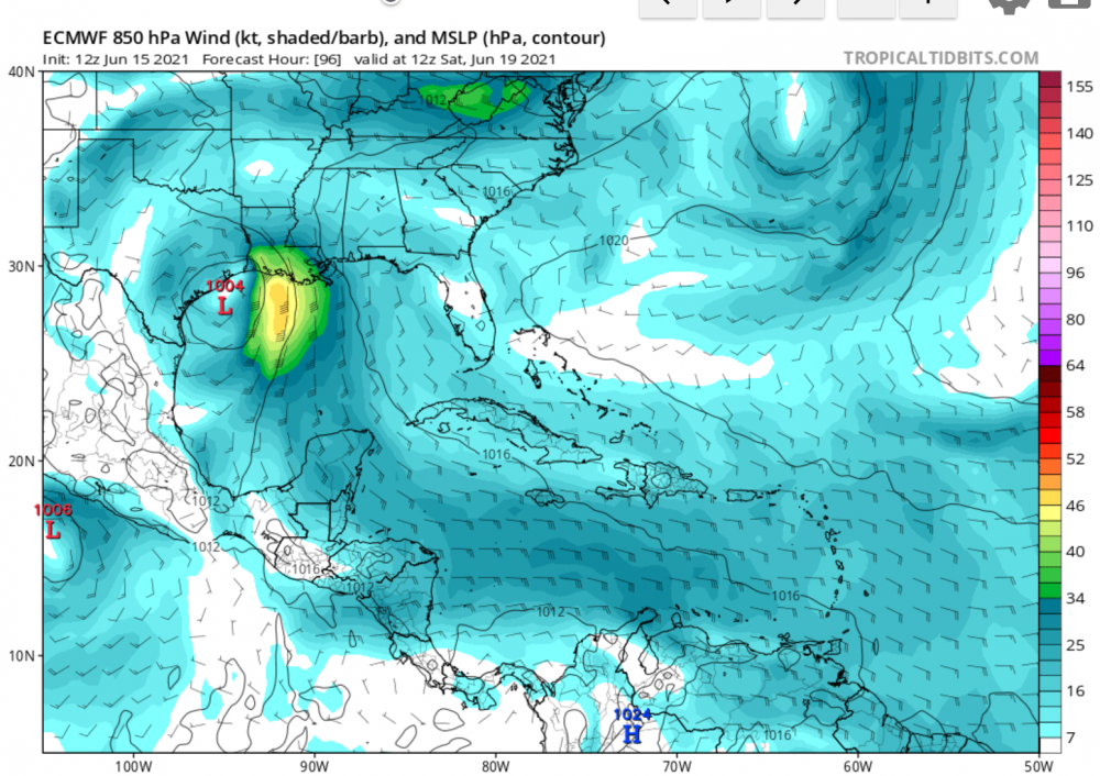
Looking at the euro. The reason behind the difference between the two maps above is the fact that the Euro is showing the ridging over the Rockies breaking down some degree. Then troughing developing across the Midwest and Great Lakes.
What's left of the mid and upper levels basically has SW energy injected into from the developing trough. This amplifying the remaining upper levels.
-
This weekends runs of the Canadian sure backed off on this system.
The organization and strength.
Last night's run shows nothing more that tropical low pressure. With a plume of thunderstorms for the FL panhandle AL, MS.
With increasing SW shear closer to land it gets.
-
3 hours ago, Ed, snow and hurricane fan said:
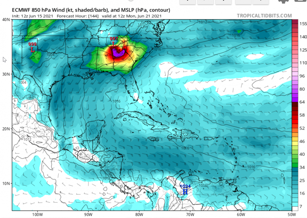
Fantasy range GFS but a TS that landfalls midway CRP and GLS, and crawls the next 2 days w/ excessive rain. GFS has been off and on showing it, but putting it off, but the now developing a week from now. Somewhere North Mexico to Florida Panhandle could be looking at double digit inches of rain weekend after next.

Honestly the GFS and Canadian have pretty much been in agreement with showing something in the southern GOM.
Even last night's 0z run both show at least a TD/ Low end TS making landfall some where on the Texas Coast.
-
9 hours ago, Prospero said:
Seems like it has been a long off-season, even though it has not been that long. At least now its fun to look at models every day and be back watching this forum for comments. Any teasers are worth their value in excitement, even random 14 day out models that come and go. Tampa Bay has already been in a strong storm a few times in 2021 models! (That is definitely preferable to being in a real life strong storm here.)
Not trying to get OT.
But I've been working out there in Clearwater off of SR 60 and McMullen Booth Road by the Ruth Ekcard performing arts center.
I can imagine it gets really sketchy out there with anything higher than a cat 1. Very low country out there.
Very obvious that with the right conditions and trajectory it will flood quickly from the storm surge.
-
Looking at the models today. Canadian and GFS.
I'd say it's a safe bet to place. From Louisiana to the big bend of FL in about 10 days.
At minimal a disorganized sub tropical storm. Worst case a organized full blown TS min hurricane.
-
On 6/5/2021 at 10:16 PM, Prospero said:
GFS keeps popping up with storms then drops off. Our typical afternoon thunderstorms in central-west Florida are still lacking which means the moisture in the ground to feed the sea-breeze collisions is low right now and it might be a late rainy season for us if we don't end up in a drought. Of course that can change in a few days time, but not in the next week or so at least.
Could be a slow start to the TS season this year as well which only amps the energy for later on. Just a thought, based on a decades long lifetime of wish-casting.
")
My thoughts as well. Alot of these small retention ponds have pretty well dried up.
Been a rather lack luster start. About a week ago seen a small brush fire off of 27 south of Leasburg, FL.
I just hope that we don't have a drought then bam.... Hurricane after hurricane. Something similar to 2004.
-
 1
1
-
-
39 minutes ago, StantonParkHoya said:
It’s like the equivalent of being in Warning criteria snow event, anticipating a foot and not even seeing a flake.
Unfortunately have been a part of both.
Uh
Quite a difference. But it happens
-
It's been warm.
Near 90 the last three days.
The front is near by.
-
Quite warm yesterday. Up near 90 yesterday and for the next two days.
Ready for the rainy season to kick in. Nothing like sitting on the porch listening to the thunder and heavy rain from the seabreeze collisions.
-
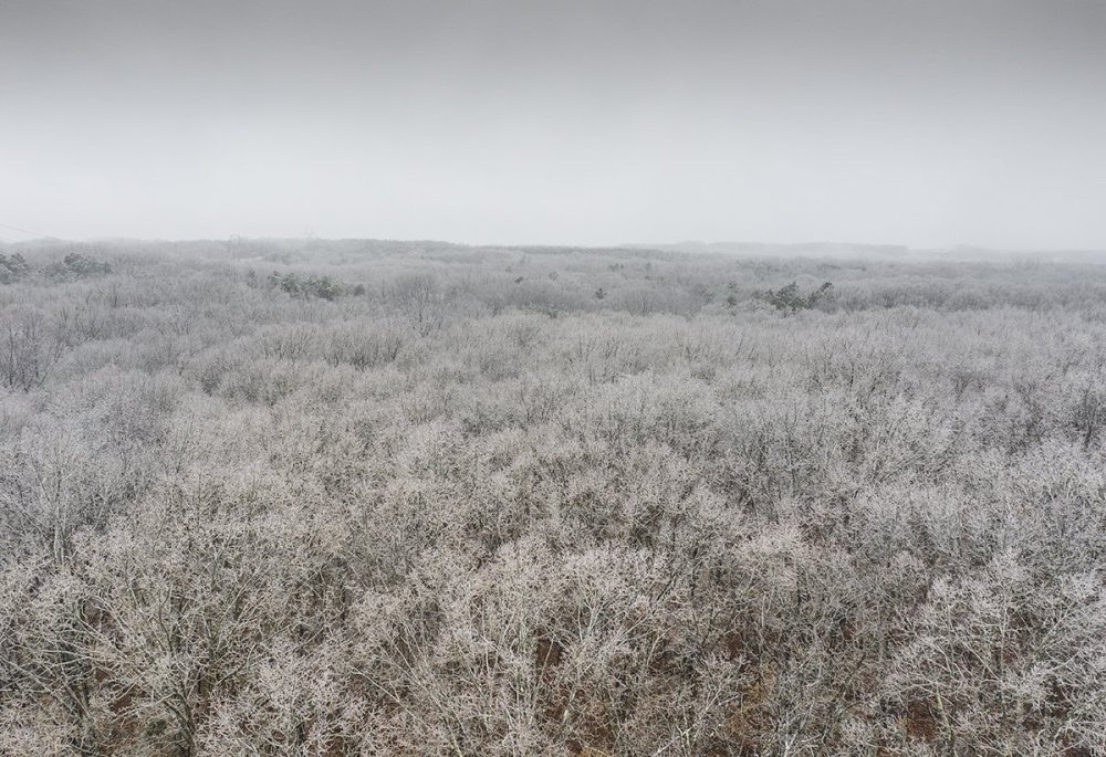
7 minutes ago, eyewall said:
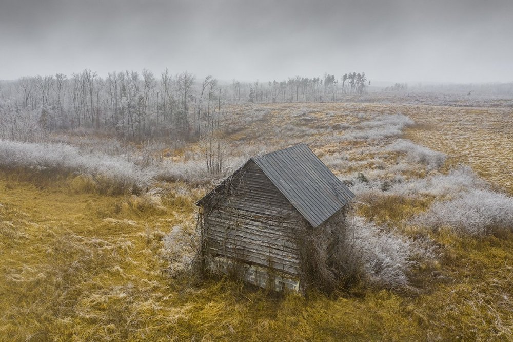
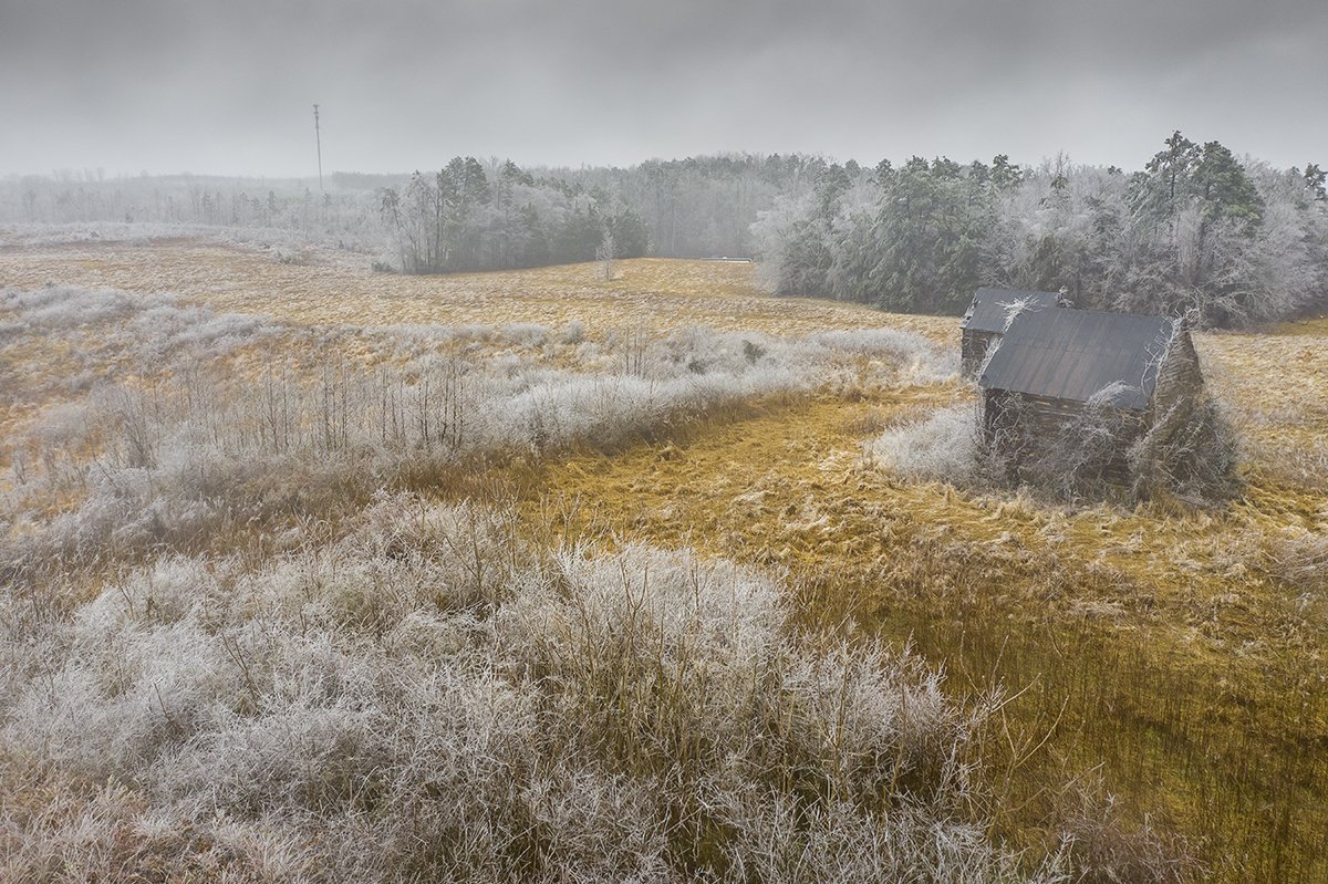
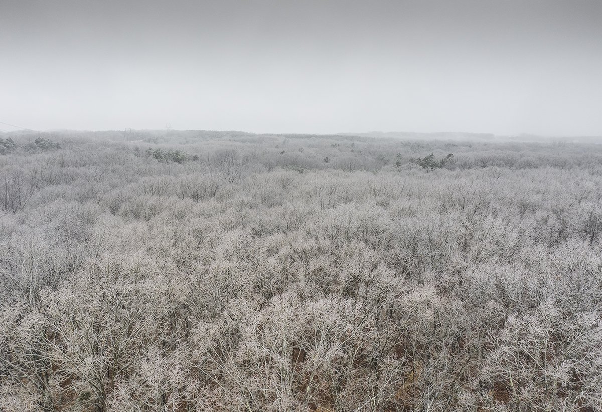
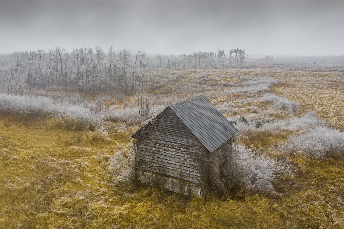
Actually just north of the border on the VA side for the cabins and the icy trees were a few miles north of Roxboro in person county off 501.
Those cabins were once tobacco barns.
-
1
-
-
2 hours ago, eyewall said:
Just north of Roxboro near the VA line this afternoon.
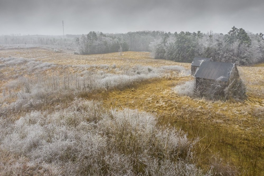
Nice pictures.
SE person county? Looking back towards from the west northwest
-
According to an old neighbor. Via txt messages.
They just had the worse ice storm she can reminder. From some of the pics on FB. Looked pretty bad.
Trees snapped like toothpicks. No power.
Near Roxboro
-
On 2/5/2021 at 10:40 AM, turtlehurricane said:
Only a day after hitting the low-mid 40s, which was frigid cold for me, it is already up to 75 F and undoubtedly heading to 80 F today. That's the beauty of South Florida winter. It might get cold sometimes, but it doesn't last long.
Ultimately I did not go drive up north due to covid restrictions and such. And honestly, I don't think I could've handled the cold up there anyways. I have not felt sub-freezing temps in over 8 years.
It was the coldest morning here.
-
23 minutes ago, BullCityWx said:
The NAM tonight had a very interesting band in Orange County on Monday. Actually, I guess it was the second run in a row for roughly that same location. Someone is gonna sneak out another inch or two Monday, just gotta hope the slot machine lines up.
Most definitely. Token flakes will happen.
-
3 minutes ago, CAD_Wedge_NC said:
Dude.... really?? .....Stop trolling.
Not trolling.
This is not a proper miller b storm. Anybody with enough common sense without a met tag can tell that this setup is not favorable.
-
1 minute ago, magpiemaniac said:
I do appreciate the real talk even though it hurts. I’ll settle for this little 0.25” snow tonight. It’ll be gone when I wake up.

Thanks it hurts I know. Been there done that.
But you are correct.
-
Just now, Ghicks said:
Well I have a white ground for now will see what tomorrow holds
Enjoy that tonight. Sorry. This time tomorrow you will be asking "what snow"
-
Just now, magpiemaniac said:
You guys are bustin’ our gonads here.
 LOL
LOL
I know. I won’t shoot the messengers. Haha!
Enjoy your low to mid 30s.
You can look at radar tell by the angle and trajectory. It's not going to happen south of the VA border. Too much WAA with this setup.
Sorry.
Where ever you are expect your temps to creap up. 35-40.
-
 1
1
-
-
2 minutes ago, griteater said:
3km NAM has warmed for 5 straight runs. At this time yesterday, it had freezing rain down to the NC/SC state line Sun AM and now it is up close to the VA/NC state line. Wouldn’t bet against it either in a warming aloft scenario like this
You are right. Considering the angle and trajectory... Too much WAA going to happen.
You can see it on radar.
Oh well the mountains about to have one hell of a storm.
-
0z hrrr pretty well shows a all rain event for NC,SC
Narrow line southern VA heading north.
-
FWIW TWC weather app. Has snow over the mountains breaking out roughly 1-130. Rain east roughly 2am. No zr or sleet.
-
5 minutes ago, Met1985 said:
Yeah this upslope event is going to be one of the best in years if the models continue to trend the way they have been.
We will see. Not your typical miller b transfer.
Opens up into a huge massive trough. With the blocking downstream makes me wonder if we can get the cold on this side of the globe. Maybe a cold start to Feb and finish to March.
-
I'm going out on a limb.
Looking at current trends
Y'all mountain folks should do well.
I don't really agree on the transfer. I do see the possibility of y'all having zr. But should be limited.
Once the trough axis swings through @ h5 should be a decent NWF event afterwards.
-
1
-


June Observations 2021
in Southeastern States
Posted
Looking at radar tonight and what is depicted on the models as far as a potential tropical cyclone.
There is a weak area of LP over the GOM around and west of Tampa/Clearwater.