

FLweather
-
Posts
2,419 -
Joined
Content Type
Profiles
Blogs
Forums
American Weather
Media Demo
Store
Gallery
Posts posted by FLweather
-
-
1 minute ago, Touchet said:
Does anyone really know what is gonna happen Tuesday?
No
-
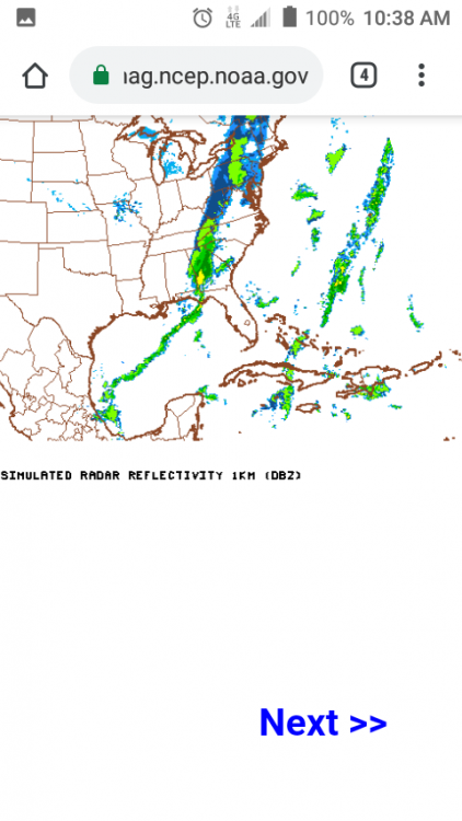
Some low 40s showing up under this band on radar atm Jacksonville SW towards Gainesville.
Can't help to feel places RDU east maybe see something Frozen.
-
 1
1
-
-
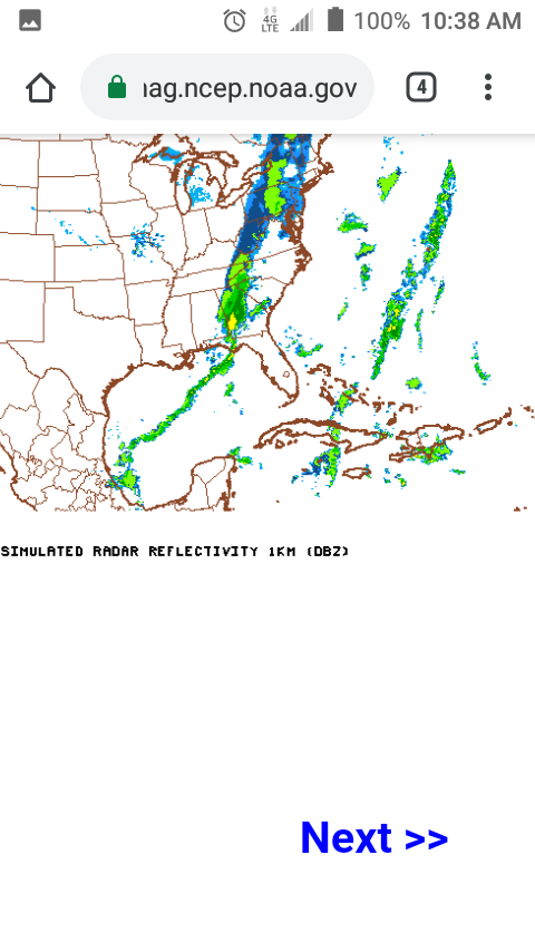
Looking at the radar over GOM/FL. Moisture pushing north. Especially Tallahassee.
Maybe some flurries later tonight East of I95 in NC? That is if BL temps cool off and moisture pushes west enough.
-
22 minutes ago, FallsLake said:
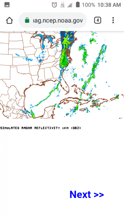
It almost looks convective like summer time precip maps. There could be a lot of "haves and have nots".
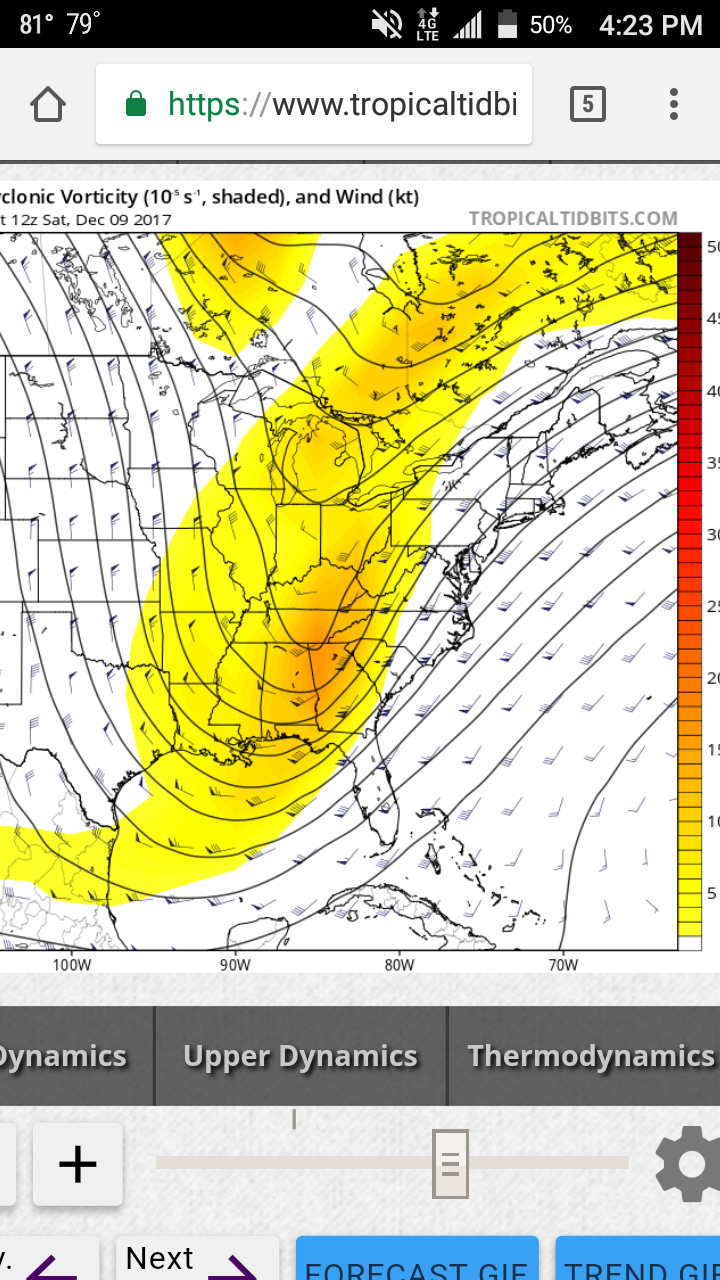
If you look at the Sim Radar. It appears to develop a weak LP center SW GA to Wilmington. With a "NW snows" on the backside.
-
6 minutes ago, CaryWx said:
It's the 84hr NAM. Show that look at 48hrs and maybe more believable?
If you believe the NAM atm
From GA/TN line would be snowing north of. ATL is moderate to heavy rain.
-
That depiction of NAM doesn't look great. Almost say a clown map.
Reminds me years ago following along on a Arctic front/clipper that was supposed to bring snow to ATL I85 Northward ATL had thunderstorms in the low 40s.
Can't shake the feeling this front may pull the same stunt.
-
Radar starting to show developing showers.
Upstate SC to TN,NC to around the triad.
Maybe icy and slick for some in the morning.
-
1 hour ago, CaryWx said:
No way that temp chart verifies. 22 degree difference between Greensboro and Winston-Salem? No way
I've seen stranger things in Person County.
If you think it's impossible think again.
Hard fetch. I see two important details.
There is a CAD although warm. And that's the artic front.
-
41 minutes ago, Met1985 said:
Yeah the 00z NAM looked impressive for sure. We will have to see how things turn out as this is very moisture latend but we really need the cold air to rush in here to get a sizable snow.
Hrrr looks interesting. Over done on some aspects.
But should fill in over GA AL TN etc. Multiple surface lows in GOM/Fl. At least 3. Judging by radar too.
-
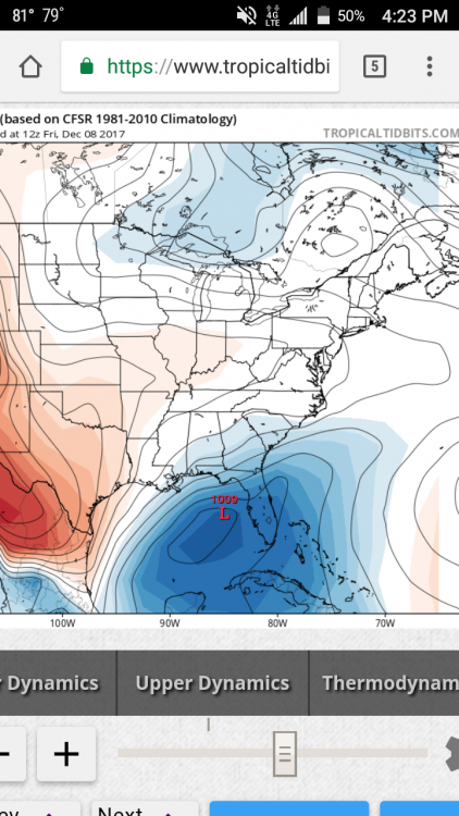
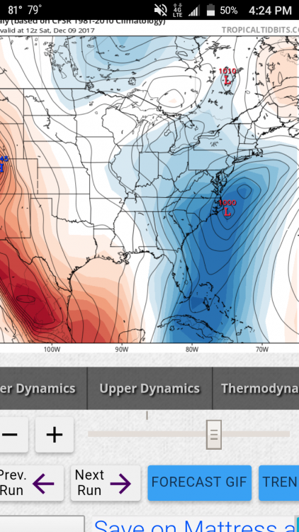
There is a trough of tropical entities off the SE coast. If you watch one might as well watch the other two.
Gom/FL FL to SC. SC to NE eventually but still around Bermuda.
There is still a very board anticlyclone aloft. Seen that tonight with the East coast seabreeze.
Some kind off broad scale trough
-
Snowing in San Antonio TX atm per my cousin via FB
-
3 minutes ago, wncsnow said:
Only bad thing is the temps on the NAM are borderline even for foothill areas
Cause this Nam Run basically keeps the surface front pinned up near and east of the mountains. In the foothills.
-
7 minutes ago, Buddy1987 said:
I still think that the "digginess" involved with the northern stream energy is somewhat stronger than progged and may have some type of adverse affect on the tilt of the trough. It seems to be responding to that energy if you examine 5h closely.
I agree looking at WV loop. That one Tiny piece of Shortwave energy diving southwest from CO to NM to AZ may help keep the energy more consolidated. Not ATM outwest shows a major wrapped up closed h5 from TX to NC. But maybe stronger in sense. Last few frames looks like its wetter maybe more NW push of moisture over TX and NM
-
30 minutes ago, Lookout said:
12z icon says the 85 corridor is going to be white
gfs sure seems out there by itself right now.

I've been thinking this has the writing of a I65/I85 corridor special. What's up with the precip streak from central AL to SW NC?
-
3 minutes ago, DopplerWx said:
anyone hoping the warm nose isnt as strong as modeled on the hi-res nam is going to be very dissapointed.
Around 700 and 800mb? Nam was showing that yesterday on the soundings in Person County. Above and below cold enough. Other than warmish BL temps.
-
14 minutes ago, avalanche said:
Hillsboro/Roxboro/Summerfield/Oak Ridge etc most always seem to be unaffected by the "warm nose". Of course, last February's sleetfest was an exception.
That one big storm in Jan 2010. Got roughly 8-10" can't remember. But during the height of the storm that was mostly pingers. Trust me. If RDU has mix issues so does Roxboro. Just takes less time to recover from it
-
Robert throwing out his first guess map too for his members. Interesting though he mentioned maybe time to throw out global models for such small scale system. Guess he talking about short range/medium range models.
-
24 minutes ago, burrel2 said:
12z JMA is a big dog! This is the best look possible, IMO. I hope it's on to something. Hard to tell with the crummy maps, but it looks like this is drop 1"plus of liquid across my area with supportive temps for snow.

Not all of that is frozen. Alot of that falls as rain. But to continue the Jma. H5 slightly negative.

-
34 minutes ago, LovingGulfLows said:
If we learned anything from January this year, warm noses are not easy to "scour out". I'd be very skeptical of models showing heavy snow through dynamic cooling.
The is no warm nose. Issue is marginal BL temps. The lowest 1500 feet or so. Above that all the data if seen supports snow. It's either gonna rain or snow.
-
1
-
-
1 hour ago, WarmNose said:
Temps won't be an issue. It will make its own cold air

Someone mentioned a Lee side trough? I can remember 7'ish years ago a Lee trough set up here in the upstate and we must have raked in 4-5 inches with temps hovering around 40 degrees. It was ridiculous
I thought of that storm too. I think I know what you talking about. Charlotte area had thundersnow
-
2
-
-
1 minute ago, CAD_Wedge_NC said:
Confidence is building......
With the EPS ensembles included? Imo this showing a early season I85/I65 special.
-
11 minutes ago, Disco-lemonade said:
gfs once again weaker with the gl low
Lee side trough showing up. Lee side snow shadow and enhancement in precip probably. From Charlotte to GSO/WS east with the enhancement of lift!? Not the first run of GFS being east and showing a Lee side trough.


Southeast Sanitarium - A Place to Vent
in Southeastern States
Posted
Beautiful.
Same here in my backyard. Some red bud trees already blooming.
Of course though around this area stays green year round.