.jpeg.88e30b1573920286ceacf89f239564d2.jpeg)
wolfie09
-
Posts
17,315 -
Joined
-
Last visited
Content Type
Profiles
Blogs
Forums
American Weather
Media Demo
Store
Gallery
Everything posted by wolfie09
-
.thumb.jpeg.b9e232a6b43e01b7eeee3144246db864.jpeg) Looks like Canadian jumped towards the GFS..
Looks like Canadian jumped towards the GFS..
-
Looks like the Canadian has several waves along a CF.. Stalled/slowed front due to the WAR, fun lol
-
In all seriousness the last couple runs of the GFS uses that cutter/CF to beat down the SE ridge but not totally, enough to bump these waves farther north though..See how that looks as we get closer lol
-
We'll get em in 12 days..
-
Starting to see some flakes flying here as this band is pretty"broad" and somewhat weak and disorganized with some embedded heavier burst .
-
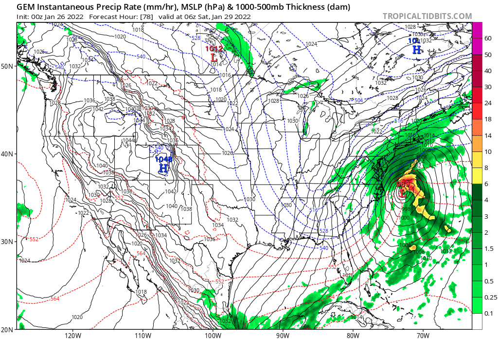
As the upper level trough becomes negatively tilted late Friday night into Saturday, an upper level low will develop over the Mid Atlantic, which will eventually kick the deepening low northeast off the east coast and into New England. This in turn will support a strong nor`easter off the coast of the Carolina`s to track northeast along the East Coast throughout Saturday, and track east of Maine Saturday night. Model consensus continues to keep the track of the low, well to the east of the region and therefore expect only the western fringes of the low to drop some snow across the far eastern boarder of the region Saturday afternoon. Otherwise, expect the remainder of the forecast area to remain on the dry side with all but a small chance for some light lake effect snow southeast of Lake Ontario Saturday morning due to limited synoptic moisture and northwest flow. Then, conditions look to be mainly quiet through the second half of the weekend and into the first couple of days of the new work week as surface high pressure will span across the region. However, the upper level trough aloft will remain intact across the Mid-Atlantic and Northeast which will not only keep the cold air in place but also provide for some chances for a few snow showers Sunday night as the trough axis passes overhead.
-
That starts at 7pm this evening..
-
Don't worry guys we'll get em in 14 days..
-
Cold has been more impressive than the snowfall here.. Average low so far of 2.7°..Feb 2015 had an average low of 1°, probably won't get that low but we do have several more chances at below zero this week..
-
Both OP models have cutters around that time period, pretty much guaranteed warmth under that scenario.. Obviously far out so it can still change but not much to look forward to as it stands now..
-
Solid looking band..To bad it's between everyone right now lol
-
New map fwiw
-
I'm not sure I've seen buffalo use the ukmet lol They like to go with the normal three, GFS, Ggem and euro+ensembles..SR it's pretty much rgem and 3k/12k NAM..
-
Wpc this morning did place a low chance for 4"+ in and around buffalo..They also had a small area of moderate tomorrow, looks like Hannibal/Fulton area..
-
It did on this site.. Looks a little north of the Hrrr as it has the heaviest near S/C Oswego county..
-
Meanwhile, the next upper level trough will be crossing the Canadian Prairies and northern Central Plains Wednesday night and Thursday supporting a surface low and cold front to cross the Great Lakes. The cold front will continue its eastward track across towards the lower Great Lakes, reaching the region late Thursday night, where the western portions of the forecast area will see the next round of general snow showers. && .LONG TERM /FRIDAY THROUGH SUNDAY/... A cold front on the western doorstep early Friday morning will cross the state from west to east throughout the day on Friday and support a general widespread snow. Meanwhile, the trough supporting the front will continue to dig and deepen across the Ohio Valley and into the southern states, before pivoting it axis across New York State and across New England Saturday and Saturday night. As the trough digs deep, a surface low will develop off coast of the Carolinas, where it will track northward along the Eastern Seaboard towards New England by Saturday. As of 12Z model guidances, the nor`easter remains to track far enough east keep the majority of the snow out of the forecast area, however a shift westward can change this. For the later half of the weekend and start of the new work week, upper level troughing will remain across the east coast and allow a shortwave to pass through. With the passage of the shortwave, surface low and its associated fronts will slide southeast across the Great Lakes Sunday, reaching the region Monday supporting the next chances for snow showers.
-
Off Lake Ontario... Expect a band of lake effect to develop Tuesday morning right behind the departing clipper across southern Oswego County. The band may also clip far northeast Wayne and northern Cayuga counties at times. This band of snow may move north into central or northern Oswego County briefly during the mid to late afternoon as boundary layer flow backs more westerly just ahead of an arctic cold front. The band of lake effect will then merge with the incoming arctic cold front and possibly intensify as it moves back south across Oswego County and portions of northern Cayuga/northeast Wayne counties. The band may briefly become heavy at this point before moving farther south and breaking apart into weak multiple bands overnight after the arctic cold front pushes south of the lake. As far as accumulations go, if a solid band comes together at the southeast corner of the lake for a few hours Tuesday evening, there may be 4-8" of fluffy accumulation in some areas. Previous runs of the Canadian GEM were the only model that supported this idea, with other high-res guidance veering flow too fast late Tuesday with the arctic front to allow a single, dominant band to come together. If this verifies, accumulations would be held under 3". Given the model differences, the lake effect potential southwest of Lake Ontario Tuesday and Tuesday night is a low confidence forecast at this point. Off Lake Erie... Weak WNW upslope snow showers will develop Tuesday morning and continue through the day, with relatively minor accumulations limited to higher terrain east of the lake. Moisture will deepen some Tuesday night as the trough and arctic cold front cross the lake, resulting in a little better thermodynamic environment over Lake Erie. Model guidance also suggests the potential for a Lake Huron connection to at least briefly tie into Lake Erie, first across southern Erie County, then moving south and west across the western Southern Tier overnight. Overall the intensity of Lake Erie lake effect will be limited by a short fetch and lack of deep moisture and synoptic support. The potential for 4+" accumulations will be tied to whether the Lake Huron connection develops, and if it is able to stay in one spot long enough. If it does, there may be some local 4-7" accumulations Tuesday night across the Chautauqua Ridge. This too is a low confidence forecast given the sensitivity to the difficult to predict upstream connection. What is certain, it will turn much colder again Tuesday night as arctic air moves back into the region. Lows will drop into the single digits in most locations, and teens below zero for the North Country by daybreak Wednesday. Wind chills may drop to colder than -20F across the North Country.
-
Upstate NY Banter and General Discussion..
wolfie09 replied to wolfie09's topic in Upstate New York/Pennsylvania
Well it looks like you guys may get your wish.. -
I think we can all agree on #8 lol
-
Wpc FWIW.. GFS gives us 2"-4" or so on Friday..
-
Lake Ontario region can still do ok with a late bloomer if it backs enough west lol Here we usually do better with wrap around/NW flow compared to NE flow which has some DS properties lol
-
I guess no Canadian guidance at 12z lol Neither CMC nor Rgem have run on any of the normal sites yet .