.jpeg.88e30b1573920286ceacf89f239564d2.jpeg)
wolfie09
-
Posts
17,315 -
Joined
-
Last visited
Content Type
Profiles
Blogs
Forums
American Weather
Media Demo
Store
Gallery
Everything posted by wolfie09
-
.thumb.jpeg.b9e232a6b43e01b7eeee3144246db864.jpeg)
Upstate NY Banter and General Discussion..
wolfie09 replied to wolfie09's topic in Upstate New York/Pennsylvania
Rumor has it Bills OC wants to reunite with tua.. -
He said close..1 bump SE it's a few inches verbatim..
-
Euro has been lowering totals to the west though..
-
Upstate NY Banter and General Discussion..
wolfie09 replied to wolfie09's topic in Upstate New York/Pennsylvania
In a few years you will be watching his grandson play lol -
It's either going to be a huge win or huge fail on the part of the GFS and it's ensembles..
-
Ukie decided to jump back SE and join the GFS lol
-
It's still way out there but the Canadian is slower with the front by about a day compared to the GFS .
-
So just like last event the Canadian and regional restrict the band closer to the lake as it's pushing south.. The high Rez Canadian keeps the band intact as it's moving south.. Obviously rooting for that scenario lol
-
Yeah euro takes longer to move the front through, not until Friday night..We get 4 warm days, Tues,wed, Thur and Friday, obviously this is for CNY..We won't have any snow left on the ground to enjoy the cold lol Especially since the snow is still pretty dry.. Hopefully we start to make some new snow after it clears lol
-
Man last night euro was pretty ugly lol Pumping those southerlies for like 4 days..It's not 60s type torch but more low-mid 40s followed by some 50s just ahead of the front on Fri...
-
Always got the GFS lol
-
Yeah right now the GFS is the outlier.. Could be decent for our buddy going down to LI..
-
One more year of this I'll be pushing myself overboard..
-
Looks like the trend so for tonight has been west, Nam, rgem, icon..
-
Well at least for this run the GFS is quicker with the front, moisture gathering to the south.. Atlantic ridge holding it's ground verbatim..
-
The January thaw will commence Monday...the last day of January, and will peak just after the end of this forecast period. Deep southerly flow coupled with increasing heights aloft will allow for temperatures to increase towards the freezing mark Monday...and then approach the lower 40s Tuesday, and upper 40s Wednesday with a bit of a gusty southerly breeze. This southerly breeze will limit the cooling Tuesday Night, with temperatures dropping just a few degrees, especially across the Lake Plain. With surface high pressure anchored off to our east our region will remain dry through Wednesday afternoon
-
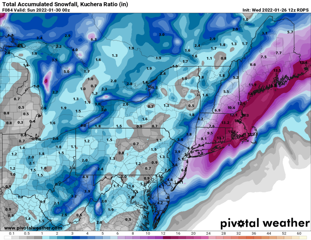
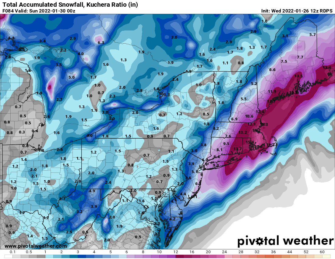
A southwest flow will continue through the first half of the Thursday night as a cold front rapidly approaches the region. Cold air advection aloft will move across the Lakes and a lake response will begin northeast of the Lakes Thursday evening. Snow showers will likely organize along the cold front as it moves through the region overnight. A few inches of snow is possible along the front with lake enhancement northeast of the Lakes Thursday evening moving southeast of the Lakes by Friday morning. East of Lake Erie... Snowfall accumulations of 2-4 inches are possible, mainly from the Lake Erie shoreline from Chautauqua county into northern Erie and Genesee counties. Similarly east of Lake Ontario... snowfall accumulations of 2-4 inches is possible across Jefferson county and northern Lewis counties Thursday night, moving south to Oswego county Friday morning. Additional snowfall accumulation from northwest flow may give northern Cayuga/Oswego counties a few more inches resulting in a potential Advisory late Thursday night-Friday morning. A west-northwest wind will move into the region overnight and temperatures will fall into the teens across western NY and single digits across the North Country. Light lake effect snow showers will continue across western NY Friday with the best chance southeast of Lake Ontario. Cold Friday, temperatures will peak in the teens to low 20s.
-
Must be the increasing sun angle, 13° with sun and no wind feels ok lol
-
Powerful CF . KSyr drops 30° in 6 hours.. Granted it's 200 hours out lol
-
CPC picking up on the potential warmth.. Just "leaning" as of now..
-
Last night's euro was so slow with the front we get 3-4 "Warm" days with AN temps..
-
If the GFS is correct which it isn't, sizzlecuse would have a shot at 60° and another rainmaker to follow lol
-
Upstate NY Banter and General Discussion..
wolfie09 replied to wolfie09's topic in Upstate New York/Pennsylvania
Rangers continue to"surprise".. -
Well this about all we got over the next 7-10 days.. The upstream cold front will pass through the area Thursday night, bringing the next round of snow. There will be initial southwest flow lake response, although it might take a bit to get going but should focus some minor accumulating snow northeast of the lakes later Thursday evening and overnight, especially off Lake Ontario where several inches will be possible, before the flow turns more westerly by Friday morning. Lake snows will gradually wind down during the day Friday even though colder air will continue to progress southward into the region. Air mass drying out significantly with the flow turning northerly as Canadian high pressure builds into the region