
.jpeg.88e30b1573920286ceacf89f239564d2.jpeg)
wolfie09
-
Posts
17,315 -
Joined
-
Last visited
Content Type
Profiles
Blogs
Forums
American Weather
Media Demo
Store
Gallery
Everything posted by wolfie09
-
.thumb.jpeg.b9e232a6b43e01b7eeee3144246db864.jpeg)
Upstate/Eastern New York-Springtime?
wolfie09 replied to BuffaloWeather's topic in Upstate New York/Pennsylvania
Few rumbles and some moderate rain. -
Upstate/Eastern New York-Springtime?
wolfie09 replied to BuffaloWeather's topic in Upstate New York/Pennsylvania
GFS still has burst of snow early Saturday, especially KSyr South and east.. Looks like another LEK special lol.thumb.png.ee73424301de727a49a593dae1cefda8.png)
-
Upstate/Eastern New York-Springtime?
wolfie09 replied to BuffaloWeather's topic in Upstate New York/Pennsylvania
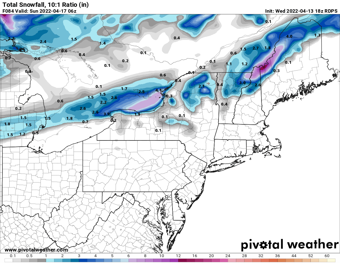
18z rgem keeps the r/s line just to the west..
-
Upstate/Eastern New York-Springtime?
wolfie09 replied to BuffaloWeather's topic in Upstate New York/Pennsylvania
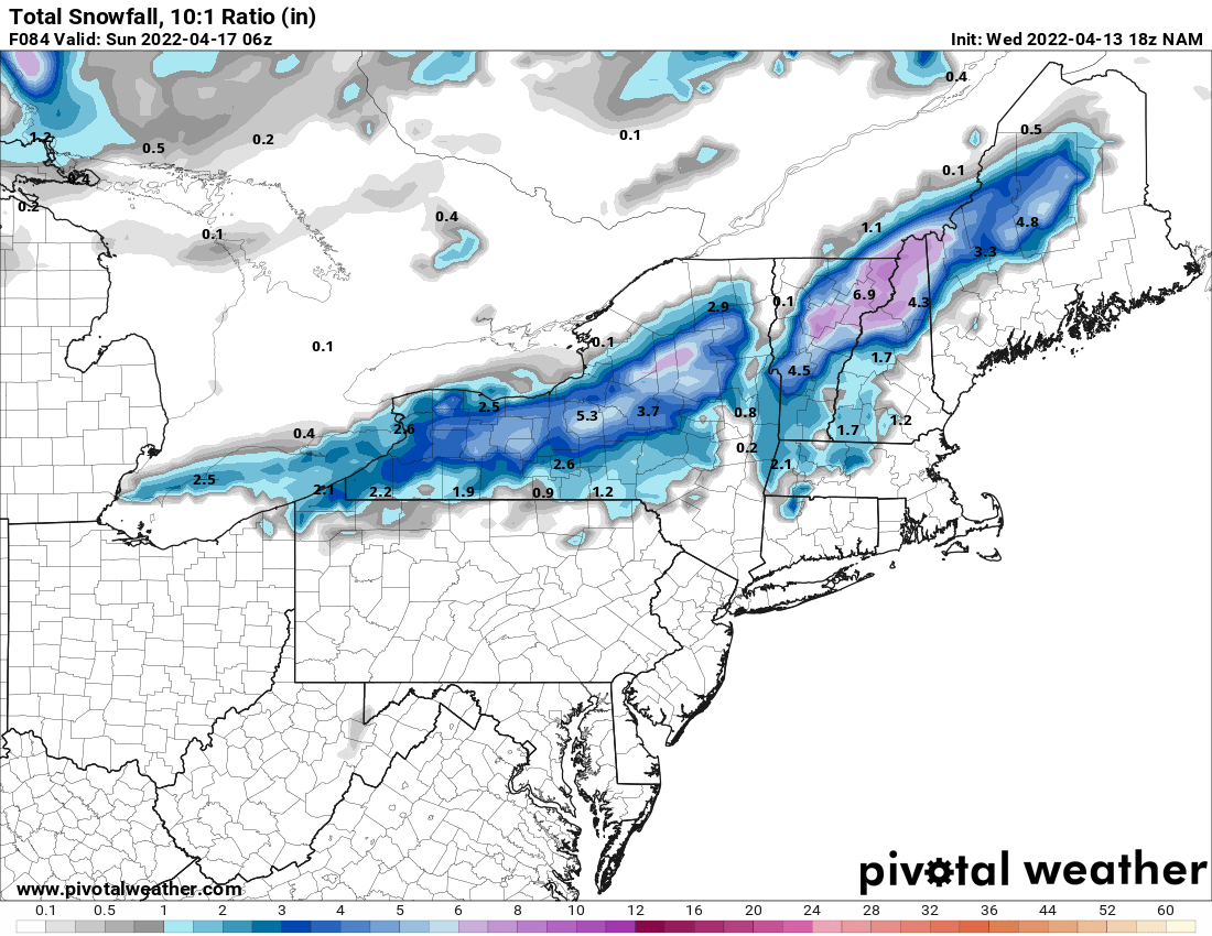
Nam hangs up the CF a little farther southeast but still wants to throw some snow into the mix.. Timing sucks though, through the day on Saturday..I think kuchie is showing half these numbers if that lol
-
Upstate/Eastern New York-Springtime?
wolfie09 replied to BuffaloWeather's topic in Upstate New York/Pennsylvania
The next issue...when will this next front push into the forecast area and then how fast will it exit on Saturday. There is some suggestion that it will hang up and then slow its forward progression with a tightening of the thermal gradient and strong baroclinic zone developing across the forecast area from SW to NE Friday night. This could bring a fairly decent period of precipitation as it slowly works through the region. P-type may even become a bit tricky as it could get just cold enough to support a mix of rain and snow across the higher terrain overnight. Have added a mix of rain and snow across the higher terrain to cover this potential beginning the second half of Friday night. Saturday...the cold front appears to move ever so slowly through the region and then it turns sharply colder on the backside. We might even see precipitation mix with or change completely over to snow late in the day at all locations. This is considering 850 hPa temps are forecast to fall to -7C then to -10C by evening. Saturday night...its looking more likely that it will be cold enough aloft (-10C/-11C) to encourage a bit of a lake response. This is taking into account that Lake Erie and Ontario are now in the upper 30s to low 40s...marginal over lake instability. Nothing significant but nonetheless impressive for this late in the season. Could see some minor snow accumulations on grassy areas across the higher terrain SSE of the lakes overnight. Temperatures wise...lows will be found in the 20s to low 30s across the forecast area by daybreak Sunday. -
Upstate/Eastern New York-Springtime?
wolfie09 replied to BuffaloWeather's topic in Upstate New York/Pennsylvania
Lol doubtful but you never know haha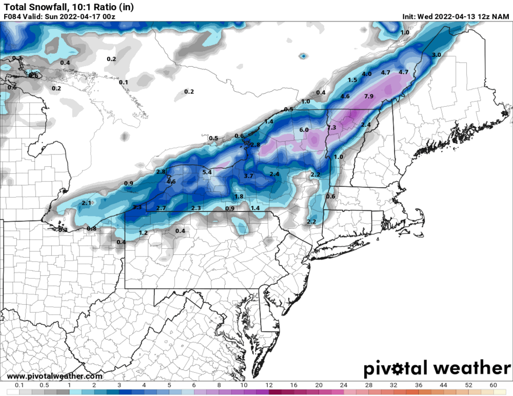
-
Upstate/Eastern New York-Springtime?
wolfie09 replied to BuffaloWeather's topic in Upstate New York/Pennsylvania
Nam showing this as well.. Could see some wet fatties mix in lol -
Upstate/Eastern New York-Springtime?
wolfie09 replied to BuffaloWeather's topic in Upstate New York/Pennsylvania
At the very least looking like a cooler air mass.. -
Upstate/Eastern New York-Springtime?
wolfie09 replied to BuffaloWeather's topic in Upstate New York/Pennsylvania
Yeah pretty much right at the 10 day mark lol GFS does continue to try and mix in some snow on Saturday morning with the next front.. -
Upstate/Eastern New York-Springtime?
wolfie09 replied to BuffaloWeather's topic in Upstate New York/Pennsylvania
-
Upstate/Eastern New York-Springtime?
wolfie09 replied to BuffaloWeather's topic in Upstate New York/Pennsylvania
Couple nice hits up in that area this year, some misses as well which is going to happen, all depends which way the wind blows lol -
Upstate/Eastern New York-Springtime?
wolfie09 replied to BuffaloWeather's topic in Upstate New York/Pennsylvania
Possibly lol That's why I mentioned it might not be fully updated but it's still going to be a below average lake effect season.. -
Upstate/Eastern New York-Springtime?
wolfie09 replied to BuffaloWeather's topic in Upstate New York/Pennsylvania
Embarrassing haha 5 "notable" events this year unless they haven't fully updated, this would be about 1/2 of the seasonal average.. -
Upstate/Eastern New York-Springtime?
wolfie09 replied to BuffaloWeather's topic in Upstate New York/Pennsylvania
We made it up to 62° this afternoon but it has since clouded up and dropped a couple degrees.. Precipitation chances starting to move into kbuf CWA, guidance all over a place wrt amount, anywhere from a tenth or two (nam) to near an inch (fv3)... -
Upstate/Eastern New York-Springtime?
wolfie09 replied to BuffaloWeather's topic in Upstate New York/Pennsylvania
Pleasant few days coming up...png.f7f8ebca6f79d9796fd6a834a84f74a5.png)
-
Upstate/Eastern New York-Springtime?
wolfie09 replied to BuffaloWeather's topic in Upstate New York/Pennsylvania
-
Upstate/Eastern New York-Springtime?
wolfie09 replied to BuffaloWeather's topic in Upstate New York/Pennsylvania
GFS and euro both have something within 200 hours lol -
Upstate/Eastern New York-Springtime?
wolfie09 replied to BuffaloWeather's topic in Upstate New York/Pennsylvania
Ontario Lake shore for the loss lol Either way to far out to think anything of it.. -
Upstate/Eastern New York-Springtime?
wolfie09 replied to BuffaloWeather's topic in Upstate New York/Pennsylvania
That's actually probably a mix of frozen crap it's accumulating as snow, either way euro has been showing this scenario on and off for next week.. -
Upstate/Eastern New York-Springtime?
wolfie09 replied to BuffaloWeather's topic in Upstate New York/Pennsylvania
-
Upstate/Eastern New York-Springtime?
wolfie09 replied to BuffaloWeather's topic in Upstate New York/Pennsylvania
Little taste of winter right now at 37° lol I hit 39° for the high so far.. -
Upstate/Eastern New York-Springtime?
wolfie09 replied to BuffaloWeather's topic in Upstate New York/Pennsylvania
-
Upstate/Eastern New York-Springtime?
wolfie09 replied to BuffaloWeather's topic in Upstate New York/Pennsylvania
.thumb.png.8eafffb817f7f3650245fc4171b807d0.png)
.thumb.png.af5c63003ac1b344321d19833660a514.png)
-
Upstate NY Banter and General Discussion..
wolfie09 replied to wolfie09's topic in Upstate New York/Pennsylvania
It was pretty much a foregone conclusion but now it's official.. First playoff appearance since 2017.. Currently tied atop the metropolitan division with Carolina (rangers have played 1 more game), the 2 teams meet on Tuesday for an important showdown..
-
Upstate/Eastern New York-Springtime?
wolfie09 replied to BuffaloWeather's topic in Upstate New York/Pennsylvania
NWS buffalo going with around 1/4-1/2".. Guidance has the lake plain 34°-35° Sunday morning so we could see some flakes flying but doubtful much accumulates...thumb.jpg.42c7c0dae29229f8ea0f5b1370be0bb0.jpg)
.png.92790ad8e935e642e2ae7772e9bb81a6.png)


.png.270b41c7bac79fd09d9b5ca92bb3bca3.png)
.png.1caa4bcb75850c54ef39ec6b1f693aa5.png)

.jpg.231736ea20d0611b1cd101439f4a2ed7.jpg)