.jpeg.88e30b1573920286ceacf89f239564d2.jpeg)
wolfie09
-
Posts
17,315 -
Joined
-
Last visited
Content Type
Profiles
Blogs
Forums
American Weather
Media Demo
Store
Gallery
Everything posted by wolfie09
-
.thumb.jpeg.b9e232a6b43e01b7eeee3144246db864.jpeg)
Upstate/Eastern New York-Springtime?
wolfie09 replied to BuffaloWeather's topic in Upstate New York/Pennsylvania
The positive is temps have fallen into the mid 70s and windy.. Still "sticky" out though.. -
Upstate/Eastern New York-Springtime?
wolfie09 replied to BuffaloWeather's topic in Upstate New York/Pennsylvania
Looks like it's going to go just to my north lol -
Upstate/Eastern New York-Springtime?
wolfie09 replied to BuffaloWeather's topic in Upstate New York/Pennsylvania
Hoping to get into a little convection lol -
Upstate/Eastern New York-Springtime?
wolfie09 replied to BuffaloWeather's topic in Upstate New York/Pennsylvania
We only got down to 71.6° overnight, hit 83° during the day but back down a couple degrees with cloud cover...DPs still suck lol In the lower 70s with a RF of 85°... -
Upstate/Eastern New York-Springtime?
wolfie09 replied to BuffaloWeather's topic in Upstate New York/Pennsylvania
Much needed rain, especially for WNY.. -
Upstate/Eastern New York-Springtime?
wolfie09 replied to BuffaloWeather's topic in Upstate New York/Pennsylvania
"Normal" Nina.. Probably some mixed events but I'd rather have a shot then missing everything to the south lol -
Upstate/Eastern New York-Springtime?
wolfie09 replied to BuffaloWeather's topic in Upstate New York/Pennsylvania
Nina to neutral conditions as it stands now, at least highest probabilities.. -
Upstate/Eastern New York-Springtime?
wolfie09 replied to BuffaloWeather's topic in Upstate New York/Pennsylvania
Actually doesn't look that bad to me..Buff is at "equal chances" of A/B/N temps and the rest of the state is "leaning" warmer at 33%-40%..Not really high confidence lol It does increase as you head east... -
Upstate/Eastern New York-Springtime?
wolfie09 replied to BuffaloWeather's topic in Upstate New York/Pennsylvania
You literally edited my screen shot lmfao.. Next time don't forget to edit the averages lol https://www.weather.gov/wrh/Climate?wfo=buf -
Upstate/Eastern New York-Springtime?
wolfie09 replied to BuffaloWeather's topic in Upstate New York/Pennsylvania
A hot and moderately humid airmass will be found over the region on Sunday. This will encourage apparent temperatures in the afternoon to climb into the mid and upper 90s. A heat advisory may be needed. A cold front moving through this airmass Sunday afternoon and night will generate thunderstorms...some of which could become strong with heavy rain. There will be the risk for localized flooding. -
Upstate/Eastern New York-Springtime?
wolfie09 replied to BuffaloWeather's topic in Upstate New York/Pennsylvania
Rochester airport -
Upstate/Eastern New York-Springtime?
wolfie09 replied to BuffaloWeather's topic in Upstate New York/Pennsylvania
Chance of a coating lol -
Upstate/Eastern New York-Springtime?
wolfie09 replied to BuffaloWeather's topic in Upstate New York/Pennsylvania
Few non accumulating flakes possible over the coming days.. -
Upstate/Eastern New York-Springtime?
wolfie09 replied to BuffaloWeather's topic in Upstate New York/Pennsylvania
The gift that keeps on giving.. -
Upstate/Eastern New York-Springtime?
wolfie09 replied to BuffaloWeather's topic in Upstate New York/Pennsylvania
It all depends on the timing of a potential CF..It always warms just ahead of it.. For W/C NY it's perfect timing to sizzle lol It doesn't make it to ENY until overnight.. But obviously 174 hours out, timing will change...thumb.png.2cfdaee91cf46313c12ddf98e6509028.png)
-
Upstate/Eastern New York-Springtime?
wolfie09 replied to BuffaloWeather's topic in Upstate New York/Pennsylvania
.thumb.jpg.c876bd6fdab3e773fe29a6632d25d0c1.jpg)
.thumb.jpg.3a938ff9b613b27b4f0afed47d7849e5.jpg)
-
Upstate/Eastern New York-Springtime?
wolfie09 replied to BuffaloWeather's topic in Upstate New York/Pennsylvania
Still blitzing out, temp down to 33°.. -
Upstate/Eastern New York-Springtime?
wolfie09 replied to BuffaloWeather's topic in Upstate New York/Pennsylvania
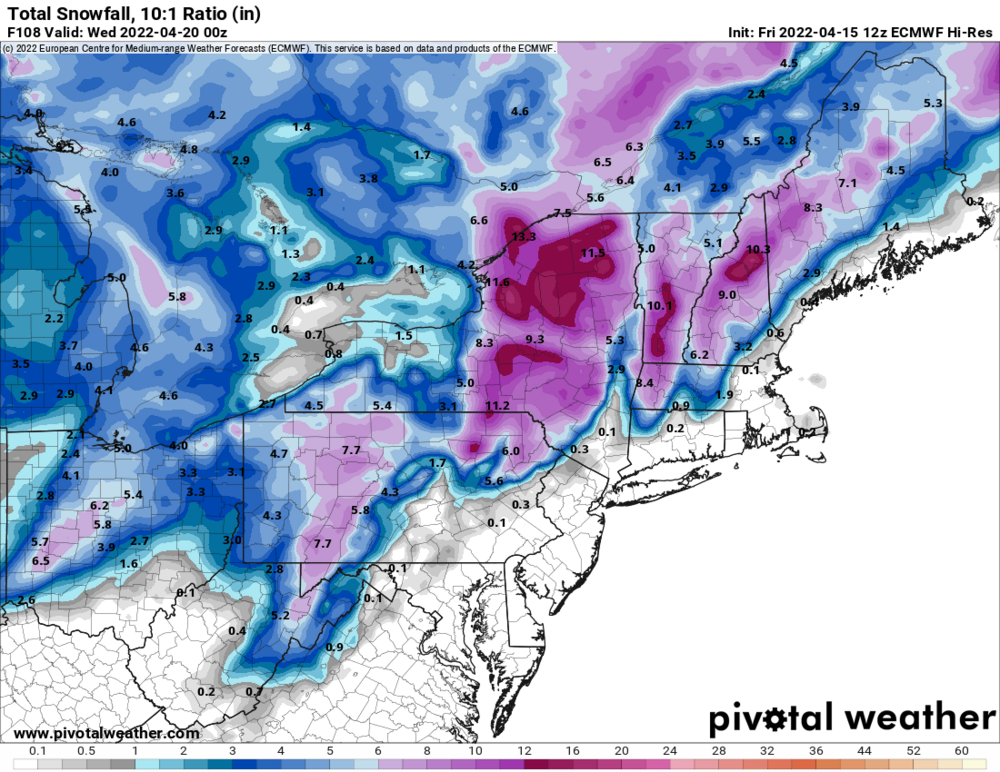
Looks like a few inches for the higher elevations east of Ontario overnight through morning...thumb.jpg.a93c9e717f9491d266029b686ec430f4.jpg)
-
Upstate/Eastern New York-Springtime?
wolfie09 replied to BuffaloWeather's topic in Upstate New York/Pennsylvania
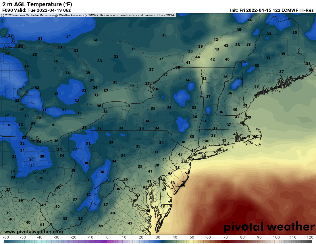
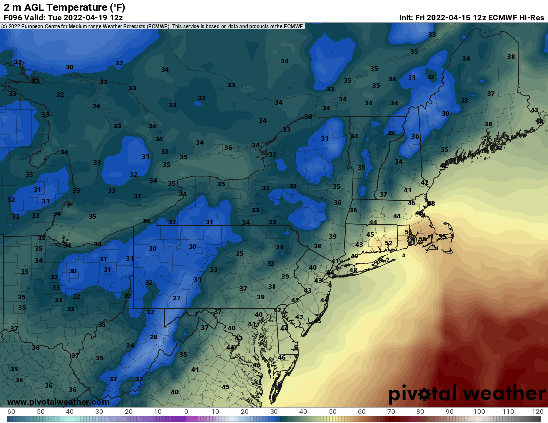
Obviously surface temps are to marginal, does try to cool somewhat overnight..

-
Upstate/Eastern New York-Springtime?
wolfie09 replied to BuffaloWeather's topic in Upstate New York/Pennsylvania
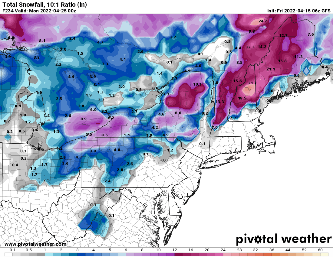
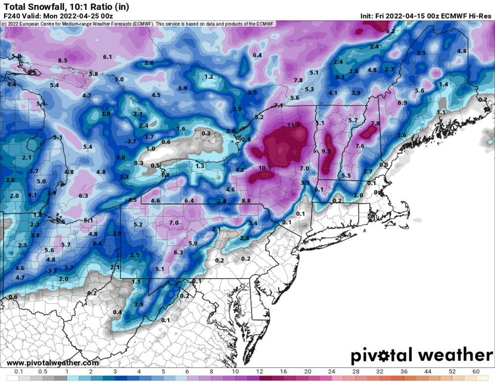
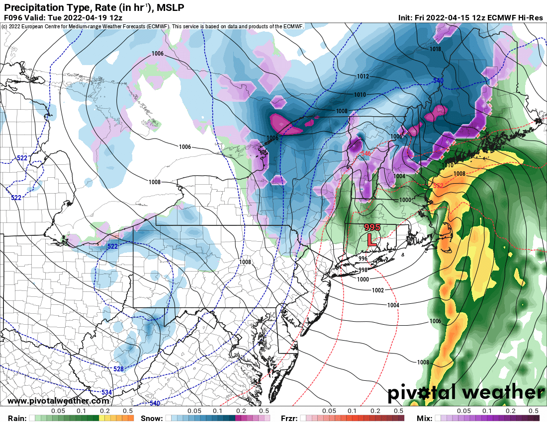
Euro with a messy mix, heavy paste job to the east..It is counting some mixing as snow..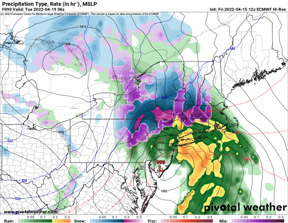

-
Upstate/Eastern New York-Springtime?
wolfie09 replied to BuffaloWeather's topic in Upstate New York/Pennsylvania
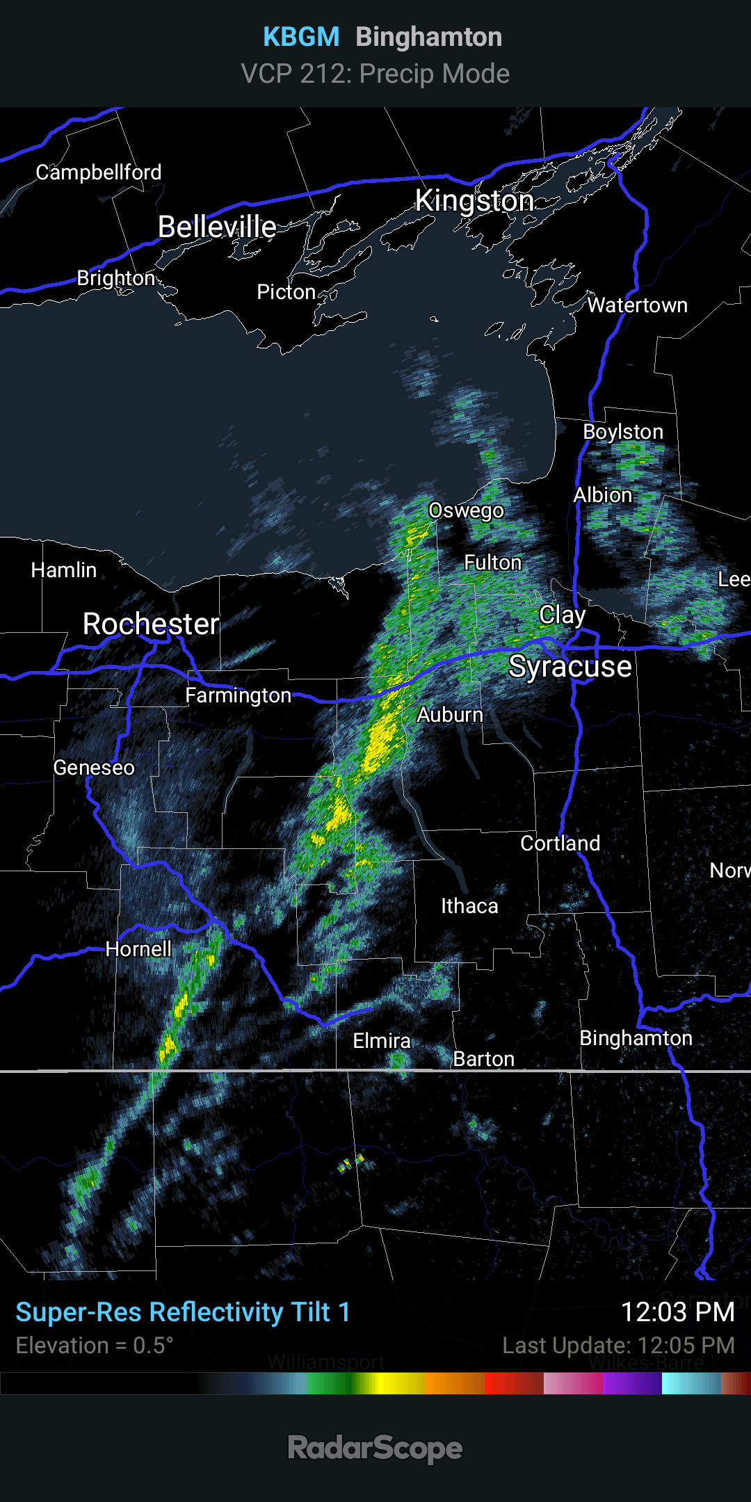
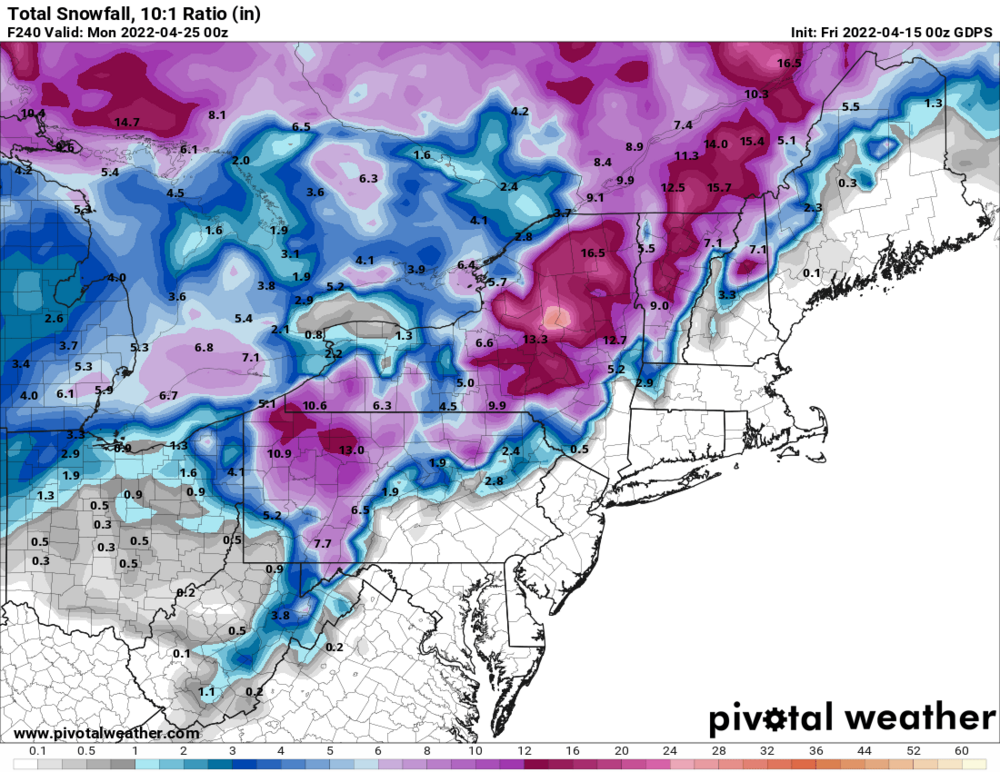
Probably going to be fringed in kbuf CWA which means liquid this time of year lol.thumb.png.4ef5424ea30632378c4f2d155bf3be41.png)
-
Upstate/Eastern New York-Springtime?
wolfie09 replied to BuffaloWeather's topic in Upstate New York/Pennsylvania
Another lol.thumb.png.5f888d6bbf282f2391ce8125f4f6b03d.png)
-
Upstate/Eastern New York-Springtime?
wolfie09 replied to BuffaloWeather's topic in Upstate New York/Pennsylvania
Time to hit up the Dacks lol
-
Upstate/Eastern New York-Springtime?
wolfie09 replied to BuffaloWeather's topic in Upstate New York/Pennsylvania
Temp took a nosedive, down 20° from the earlier high..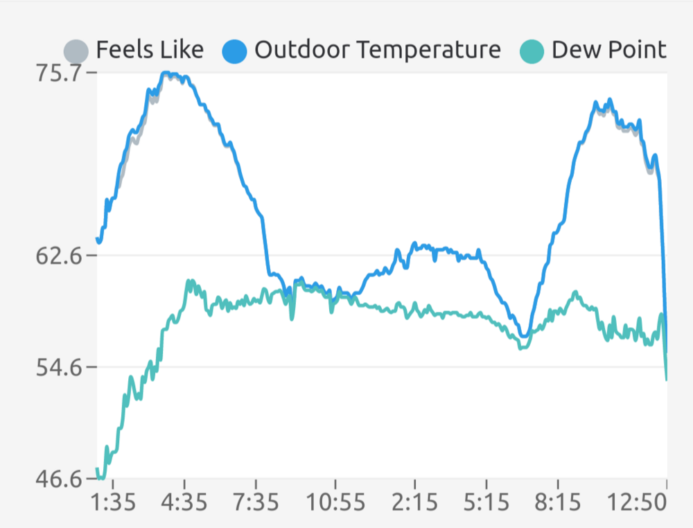
-
Upstate/Eastern New York-Springtime?
wolfie09 replied to BuffaloWeather's topic in Upstate New York/Pennsylvania
Front on the doorstep, temp already down 6°-7° from cloud cover..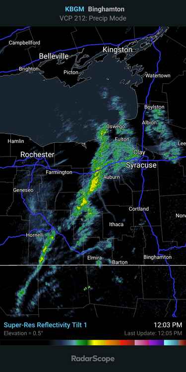


.png.babe5fc8f546c33affe84b069ce4c8da.png)
.jpg.3a96d197139c63922ad07f4b5121ff07.jpg)
.jpg.0e3fb1f811e60befd0f80a8670efa132.jpg)
.jpg.84b56b704979d377d070dac7f705af47.jpg)


.png.63587fff3f3d57d96b471772866a83ff.png)