
vortex
-
Posts
495 -
Joined
-
Last visited
Content Type
Profiles
Blogs
Forums
American Weather
Media Demo
Store
Gallery
Everything posted by vortex
-

2022 Short/Medium Range Severe Weather Discussion
vortex replied to Chicago Storm's topic in Lakes/Ohio Valley
Hahaha. Yes. Guess the sirens went off locally. NWS issued a SWS for land spouts right after. -
2022 Short/Medium Range Severe Weather Discussion
vortex replied to Chicago Storm's topic in Lakes/Ohio Valley
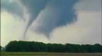
Friend of mine took this pic about 30 minutes ago just west of German Valley, Illinois. -
2022 Short/Medium Range Severe Weather Discussion
vortex replied to Chicago Storm's topic in Lakes/Ohio Valley
Took this about 35 minutes ago. -
Blowing and drifting pretty bad in the country.
-
Any idea how much you have now? Tough to measure by me because of the drifting.
-
Just over 5 some inches here so far. Lots of blowing and drifting. Should get in on southern end of death band shortly. Though less snow, this storm seemed more enjoyable than GHDIII.
-
Was thinking the same thing. lol.
-
Heaviest yet. Tough to measure.
-
Haha. Good luck!
-
Jeb would be jealous. Haha Downtown cam definitely verifies your observations.
-
Lightning strike by Quincy bout 10 minutes ago. Ripping good here now.
-
Meso discussion
-
Pretty much all snow here now at my house
-
They were at 67 degrees yesterday afternoon. Still reporting 1/4 mile visibility.
-
Pretty decent jump southeast on the 6z Nam.
-
Yep. Holding steady
-
Guesstimating we ended up around 10 inches or so. Hit the low end of forecast. No complaints here.
-
Little over 9 inches of snow here. Still snowing though radar returns aren’t showing much. Blowing and drifting some.
-
7 inches here now. Heaviest snow currently. Little over an inch the last hour.
- 856 replies
-
- 11
-

-
Measured 1.5” a little bit ago. Coming down good.
-
Where you located?
-
Kinda surprised how quickly it’s sticking after the 40s and rain today. Obviously didn’t affect ground temps too much.
-
Starting to change over to snow here now. Roads already getting snow covered.
-
6Z NAM north. Great improvement for N Illinois and Chicago.
-
Oops. Initially put this in the wrong thread. Ice jams few miles down stream Tuesday, has since melted. Something to see during these boring weather times