Snowlover11
-
Posts
9,810 -
Joined
-
Last visited
Content Type
Profiles
Blogs
Forums
American Weather
Media Demo
Store
Gallery
Everything posted by Snowlover11
-
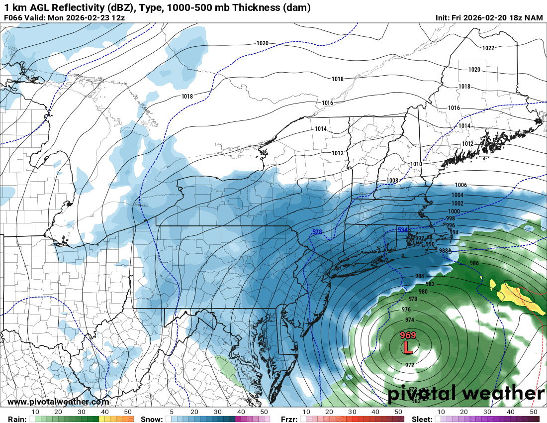
For those north and west, URGENT - WINTER WEATHER MESSAGE National Weather Service New York NY 244 AM EST Sat Feb 21 2026 CTZ005>008-NJZ002-004-006-103>108-NYZ069-070-211900- /O.UPG.KOKX.WS.A.0002.260222T1100Z-260223T2300Z/ /O.NEW.KOKX.WS.W.0002.260222T1100Z-260223T2300Z/ Northern Fairfield-Northern New Haven-Northern Middlesex-Northern New London-Western Passaic-Eastern Passaic-Hudson-Western Bergen- Eastern Bergen-Western Essex-Eastern Essex-Western Union-Eastern Union-Rockland-Northern Westchester- 244 AM EST Sat Feb 21 2026 ...WINTER STORM WARNING IN EFFECT FROM 6 AM SUNDAY TO 6 PM EST MONDAY... * WHAT...Heavy snow expected. Total snow accumulations between 11 and 15 inches. Winds gusting as high as 45 mph. * WHERE...Portions of southern Connecticut, northeast New Jersey, and southeast New York. * WHEN...From 6 AM Sunday to 6 PM EST Monday. * IMPACTS...The strong winds and weight of snow on tree limbs may down power lines and could cause sporadic power outages. Travel could be very difficult to impossible. Areas of blowing snow could significantly reduce visibility. The hazardous conditions could impact the Monday morning and evening commutes. * ADDITIONAL DETAILS...Strongest winds are expected Sunday night into Monday. However, snow will move in during the morning and afternoon hours. PRECAUTIONARY/PREPAREDNESS ACTIONS... If you must travel, keep an extra flashlight, food, and water in your vehicle in case of an emergency. Check local Department of Transportation information services for the latest road conditions. Persons should delay all travel if possible. If travel is absolutely necessary, drive with extreme caution and be prepared for sudden changes in visibility. Leave plenty of room between you and the motorist ahead of you, and allow extra time to reach your destination. Avoid sudden braking or acceleration, and be especially cautious on hills or when making turns. Make sure your car is winterized and in good working order.
-
WHAT...Blizzard conditions expected. Total snow accumulations between 13 and 18 inches. Winds gusting as high as 55 mph.* WHERE...Portions of southern Connecticut and southeast New York.* WHEN...From 6 AM Sunday to 6 PM EST Monday.* IMPACTS...Visibilities may drop below 1/4 mile due to falling and blowing snow. Whiteout conditions are expected and will make travel treacherous and potentially life-threatening. The strong winds and weight of snow on tree limbs may down power lines and could cause sporadic power outages. The hazardous conditions could impact the Monday morning and evening commutes. Strong winds could cause tree damage.* ADDITIONAL DETAILS...Strongest winds and blizzard conditions are expected to Sunday night into Monday. However, snow will move in during the morning and afternoon hours.
-
Holy shit blizzard warning!!!
-
Euro isn’t like how it was back in the day, not saying its wrong but something has to give.
-
Not really icon and uk kinda back it up although not as extreme.
-
Me but that’s because im at work lol
-
Eps. Call bullshit on the east movement
-
Either the NWS is gunna have to up the ante or something because if the NAM, GFS and even the ICON are half right, mass panic for the public tomorrow lol.
-
Man seeing old posters lock in for this one is awesome, been awhile! Starting to get excited! Lets keep this going thru tomorrow night and it’s game on!
-
Omg LI crushed!
-
Weens at mass, enter the GFS.
-
Yeah i expect him/them to double that tonight or definitely by tomorrow if things continue to trend in the right direction.
-
Yeah she’s screwed(so am I) I work at 11pm but leave around 10:15. It’s expected to late morning/late afternoon sunday
-
About 40-48 hrs away from this beginning and the gfs and nam are porn worthy! What could go wrong?
-
Truth, at my job the piles are still 10-12 feet high.
-
Holy F….
-
16-20”
-
SNJ/DE are wrecked. My goodness.
-
Thats 12z
-
Classic NAM’ing incoming.
-
Early morning 8-10am snow moves in around noon
-
WSW 6-10” 40mph winds
-
Gearing up for the historic blizzard.
-
Omg we get naked for that gfs run, please happen. Lol
-
Raining at work in yonkers, once across the bridge it was a mix. Sleeting here in Nanuet.