

WeatherMonger
-
Posts
644 -
Joined
Content Type
Profiles
Blogs
Forums
American Weather
Media Demo
Store
Gallery
Posts posted by WeatherMonger
-
-
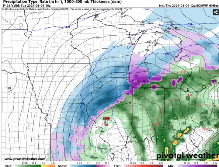
Coming down fast enough it has started to coat all surfaces again, a bit surprised to see roads coated. Evening update from ILX expects WAA to move back in later tonight and rain on things.

-
2 minutes ago, StormChaser4Life said:
I'm having the same issues so I feel this
Snow lasted about 15 more minutes after my post earlier. Switched to rain then had a dry blob push through and back to rain after. Currently white rain and 34.
Really not invested in tonight as it all gets washed away with rain tomorrow, would rather be surprised tomorrow evening and night than tonight.
Imagine being in MI tonight. Half of them have traded off a storm for a championship and the other half traded off a championship for a storm

-
 1
1
-
-
Been snowing here for about 15 minutes. Very little rain to start, don't expect much out of it, but snowing earlier than expected
-
 2
2
-
-
-
Been a steady snow here for a couple hours now. Steady enough it has overcame the pavement temps and have a solid coating on side streets. Sucks to get a late Nov. early Dec type snow in January but beggars can't be choosers of late.
Wish I was in the middle of the band just to my NE
-
8 minutes ago, StormChaser4Life said:
I would love to know what model blend they're following. I do agree rain or mix will start before a changeover in the heavier rates in deformation band but I think they're too weak with low and a bit too warm.
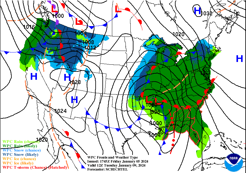
Guidance/Predictability Assessment...
The latest model guidance suite continues to offer a good overall depiction of the synoptic scale weather pattern for the first half of next week including the evolution of the major low pressure system over the Plains and Great Lakes/Northeast. A multi-deterministic composite model blend of well clustered guidance from the GFS/ECMWF/UKMET/Canadian along with the NBM and WPC product continuity was used for the period from Monday-Wednesday to produce max detail consistent with a pattern with seemingly above normal predictability. Going into the latter half of next week, gradually increasing model differences in the wake of the strong low favored some blend inclusion of compatible but smoother input from the GEFS/ECMWF ensemble means along with the models.
-
 1
1
-
-
NOAA flight Plan for today

-
2
-
-
2 minutes ago, Chinook said:
What is this purple and pink rectangle at Detroit? A car for the Motor City?
Turtle trap, has one in the vicinity and another one curious coming from the IN border......
-
4
-
-
Got power back at 5:00pm, so 28 hours of misery. Carb was gummed up on the small generator I have so couldn't run the deep freeze. Luckily I didn't lose that meat.
Did lose the refrigerator items though, last batch of deer chilli was at 67 degrees, should have thrown it in the deep freezer in hindsight.
-
-
Coming up on 9 hours without power, tomorrow may be a day of firing up the grill and smoker. Extend the life of frozen food before it's a total waste.
I'd give a thousand dollars for a nice battery powered fan right about now.
Oil lamps and propane lanterns, light the rooms but increase the temp at the same time, catch 22.....
-
 3
3
-
-
Got hit pretty hard here, have extensive wind damage across the city. More than half the people are without power in Springfield, been without power for over 5 hours now and no estimate on when power will be restored.
Hit here About 12:20pm, power went out just after the tornado warning was issued. Had a pretty good couplet that formed just east of New Berlin and then took a SE turn going slightly north of Chatham, stayed faitly strong on velocity scans going between Edinburg and Kincaid. Won't be surprised to see a few touchdowns confirmed if not a path. A lot of trees snapped half way up and significant damage to homes, but none leveled, in the Curran area.
Seen quite a few large limbs and trees snapped on the drive home, had a large tree snapped and on a couple cars on Peoria road across from State Fairgrounds, but those trees are a bit sketchy due to the way the power company trims them around the lines.
Best and worst storm, depends on how you view weather, to hit here in quite some time, i would say the most widespread damage since the 2006 March 12 tornados.
Number without power has actually increased a few thousand since 3pm, was at 44% then.

-
1
-
-
1 minute ago, MNstorms said:
Sirens are still county based so if any of the county is in the warning that's why. They never changed it when warnings went from counties to polygons.
Maybe that's it then, but I know there have been tornado warnings in Sangamon county, usually before they get to me or just after passing and the sirens in town do not sound. Maybe damage reports coming in from Sherman prompted them to sound off again.
-
1 hour ago, MNstorms said:
They're not suppose to. Someone should be fired.
I emailed the fire chief here for clarification on the second warning siren sounding. First one went off around 6:15pm for the circulation(and very likely tornado) near/over Sherman. The second sounded around 6:36pm with no active warnings over the area. The closest warning was from 6:19pm for a "large and extremely dangerous tornado" near Williamsville, well out of the way of Springfield. A new warning was issued at 6:38pm for a confirmed tornado even further ENE from Springfield.
I can't find anything supporting my "all clear" activation. Curious to see if I get a response, but I'll swear to it, they have done it before.
-
Hearing about reports of a lot of homes destroyed in Sherman.
-
1 minute ago, MNstorms said:
That's not how it works. They don't do that.
They've done it here plenty of times, been awhile simce they have went off so can't confirm if they did the same last time or not.
Wasn't any type of warning at the time, hell, wasn't even worthy of a SWS IMBY, seen like 3 pea sized hail stones and maybe a gust to 40. Like 2 miles north in Sherman may be a different story.
-
Must be the all clear
-
Tornado sirens gping off again here
-
Confirmed tornado a couple miles north
-
Line is almost here
-
23 minutes ago, WeatherMonger said:
Snowing at a rate heavy enough to overcome ground temp now, grass is about 3/4 covered and roads/driveway getting a coating.
Still coming down at a pretty good rate.

-
1
-
-
12 minutes ago, StormChaser4Life said:
That is truly white rain. Lol. Looks like it's starting to accumulate. It's snowing decent here but not hard enough to stick. Our precip looks to end soon. I'm on very nw edge of deformation band.
Snowing at a rate heavy enough to overcome ground temp now, grass is about 3/4 covered and roads/driveway getting a coating.
-
1
-
-
10 minutes ago, StormChaser4Life said:
You getting any lightning? Saw some strikes near Springfield. Reflectivity impressive near you.
Not currently, had some thunder earlier but was on a computer away from window so not sure if it was snowing then or not. Was surprised when I looked out the window and seen it snowing heavy.
Starting to coat but only going to create frozen slush

-
1
-
-
It is raining snow here now, melting on impact but huge flakes just pouring down.
-
1
-


Jan 11-13th Blizzard
in Lakes/Ohio Valley
Posted
I'm just going to go buy about 50lbs of poly fill and stake it down across the front yard.
This has been a depressing 8 days of winter.......