

Snowstorms
-
Posts
4,094 -
Joined
Content Type
Profiles
Blogs
Forums
American Weather
Media Demo
Store
Gallery
Posts posted by Snowstorms
-
-
In Canada the PM announced today "All non-Canadian citizens, expect US citizens and other diplomats, will not be allowed to enter Canada along with anyone showing any form of symptoms". All schools and fitness centers are closed. Tourist destinations like the CN Tower are closed and mall hours have been reduced to just 8 hours a day.
177 total cases in Ontario now.
-
Our Prime Ministers wife has tested positive for coronavirus. All schools across the province have been cancelled until early April and I suspect universities and colleges may follow suit.
Grocery store line-ups are absolutely ridiculous. I myself stocked up on some things lol.
My company issued a statement today saying everyone will be working from home for the next 30 days. What a time.
-
 1
1
-
-
Euro is snowless through Mar. 20. Safe to say winter is over. Sucks that it practically ended as soon as the month began but after yesterday's 62F, I am looking forward to Spring now.

~53" this winter at YYZ, which is 8" above avg, so no complaints there.
-
8 hours ago, michsnowfreak said:
After I posted that...man the snow got nuked. Just some piles left. The rogue drift here and there.
This wasn't the winter for snow cover.
-
 1
1
-
-
9 hours ago, snowstormcanuck said:
I checked...it doesn't look like it. Unless I'm looking at the wrong storm.
Feb 2013 came close but winds only maxed out at 35km/hr. 8 straight hours of +SN at YYZ. Can't get much better than that.
Easily the best storm of the decade imo.
-
21" this month at YYZ making it the 9th snowiest Feb on record. Temps will finish above avg.
-
Strong lake effect snow band about to move into Toronto. Up to 2” possible and near zero visibility.
-
50 minutes ago, Ottawa Blizzard said:
Wondering if that big squall is going to pass through Toronto early Friday afternoon?
Not feeling optimistic about it now. Conditions aren’t favourable enough for sustained lake effect across the area. Perhaps an inch in some localized areas but that’s about it. Wind direction is more westerly than NW which also plays a role.
-
20 minutes ago, snowstormcanuck said:
We never realized blizzard conditions in 1999. sustained winds were just under the threshold. Also, there was a temperature criteria back then that we likely didnt meet.
And the warning was WSW, but I dont remember completely.
We need a strong Gulf Low with the PV parked near Hudson Bay to get blizzard like conditions. A storm like Dec 92, but a bit colder, would likely meet that criteria. Isn’t there like a snowfall criteria too?
-
Around 6” at YYZ with reports of 5-8” across the GTA.
Potential for some lake effect snow later today and tomorrow across the GTA. Localized amounts of 2-6” possible.
-
 1
1
-
-
5 hours ago, snowstormcanuck said:
OB was right! This is a bit of a bust. Looks like about 5" outside and it's barely snowing. We'll probably pixie dust our way to 6" by dawn. Even areas east of us which were bullseyed are dryslotted right now.

Considering that the afternoon portion of this event sort of over-performed, it's pretty disappointing. The main defo band has produced, what, 2" additional inches here? Beh.
Not surprised. The storm ended up further east and weaker and therefore, we only got skimmed by some of the heavier returns last night. Woke up to ~6" and barely any snow piles post shovelling. This isn't the first time the models had us in the sweet spot, only for it to "bust" in the end. Disappointed to say the least.
-
1
-
-
That band approaching Oshawa is total rippage. Woulda been nice if it was 50 miles further west.

-
15 minutes ago, snowcaine said:
Yeah it's been a bit disappointing. 6" over a 24 hour period is way less exciting than over a 6-12 hour period.
Story of this winter.
Just be glad we're going to finish this season above average despite a top 5 warm winter.
-
11 minutes ago, Ottawa Blizzard said:
Heavier snow seems to have moved in...
Snow weenies in Toronto frolicking.
-
1
-
-
1 hour ago, snowstormcanuck said:
23z HRRR showing 6.7" additional. Last check, YYZ was up to 2.8" (2.8 + 6.7 = 9.5", which is definitely towards the high end of expectations, unless anyone believed the few clown RAP/GFS runs showing 12"+) .
We would need to start cranking though at some point. Cloud tops starting to cool and pivot N/NNW across E OH/W PA. Hopefully that's a good sign.
Radars look unimpressive. Looks like a dry slot towards Oakville and Hamilton.
Latest HRRR has a sharp cut-off across the GTA. Hoping we see some good returns as the storm begins to deepen and retrograde. Column has cooled so ratios should be close to 10:1. Some people are calling it a “bust” on Twitter lol.
-
45 minutes ago, snowstormcanuck said:
Remember where we were 3 days ago. Nothing to complain about.
That’s true.
Core of the storm is still south of us but we should start seeing more heavier bands after 9pm. Could tally up another 4-6” if they stay consistent.
-
38 minutes ago, snowstormcanuck said:
Have about 2-3" on the grass...pavement just finally starting to whiten up. Based on radar, it's pretty apparent the heaviest snow is going to miss us to the east. Should finish in the 6-8" range hopefully by 12z tomorrow.
We can’t have nice things haha.
RGEM nailed it. It was further east than the other models. Let’s see if we can squeeze a few inches tom with that LES band.
-
Latest HRRR now has only 6” compared to the 13” it was showing earlier lol. The Low is bit further East this run. Haven’t checked surface OBS to confirm this change.
Sometimes you can’t have nice things lol.
-
16 minutes ago, snowstormcanuck said:
Narrow band...roll the dice as to whom it effects. Seems like an impressive setup. I was reading on twitter that inversion heights are AOA 11k feet.
Wow that’s impressive! Upper air dynamics and warm Lake temps are ideal for a decent lake effect outbreak. Wouldn’t discount widespread flurries through out the day tom.
The real fun begins in a couple hours. -
3 hours ago, snowstormcanuck said:
6z RAP and HRRR actually bring a little mixing into the equation during the daylight hours today, but with a slightly further west track we rock with the death band defo zone tonight. Trade off I'm willing to make.
What’s your take on toms lake effect snow? NAM shows a stout band impacting the city for a few hours near rush hour tom.
-
13 minutes ago, snowstormcanuck said:
NAM looks like weak sauce, comparatively.
Quite the downgrade from 18z.
Seems like a nowcast event.
-
Just now, snowstormcanuck said:
RAP and HRRR have value, but when they run out to 36 hours it's sort of their clown range. I wouldn't bite on anything like that yet.
Fair point.
Let's see if NAM 3km and RGEM are in the same ballpark as HRRR.
-
Just now, snowstormcanuck said:

And, allow me....

HRRR has been solid this year.
Back to back winters with a footer? I say we do it. If we see 12", it'll be the snowiest winter since 08-09 at YYZ haha.
-
40 minutes ago, Ottawa Blizzard said:
Late February 1984 in Toronto. Some similarities. Temperatures in the low 50s Fahrenheit on the 23rd-24th, followed by 36. 4 cm (14-15") of snow on 27th-28th, followed by temperatures in the 20s to end the month.
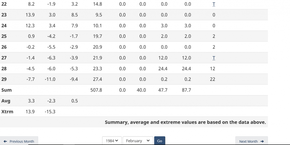
I like how you didn't use YYZ. It was a 5" storm at YYZ lol. Seems like a WNY special. I don't think there's any radar reanalysis maps that go back that far.

Coronavirus
in Lakes/Ohio Valley
Posted
I heard that. Dougie declares a state of emergency. Bans all gatherings of 50 or more people but ironically all mall remain open.
Several businesses, like Champs or Nike, close their stores for 2 weeks. All theatres are closed as well. Everyone that I know is working from home now.