

Quixotic1
-
Posts
16,434 -
Joined
Content Type
Profiles
Blogs
Forums
American Weather
Media Demo
Store
Gallery
Posts posted by Quixotic1
-
-
Towers going up. Not hopeful tjo

-
45 minutes ago, bubba hotep said:
Awesome pic!
Maybe some rain in the future?
Thank you sir!
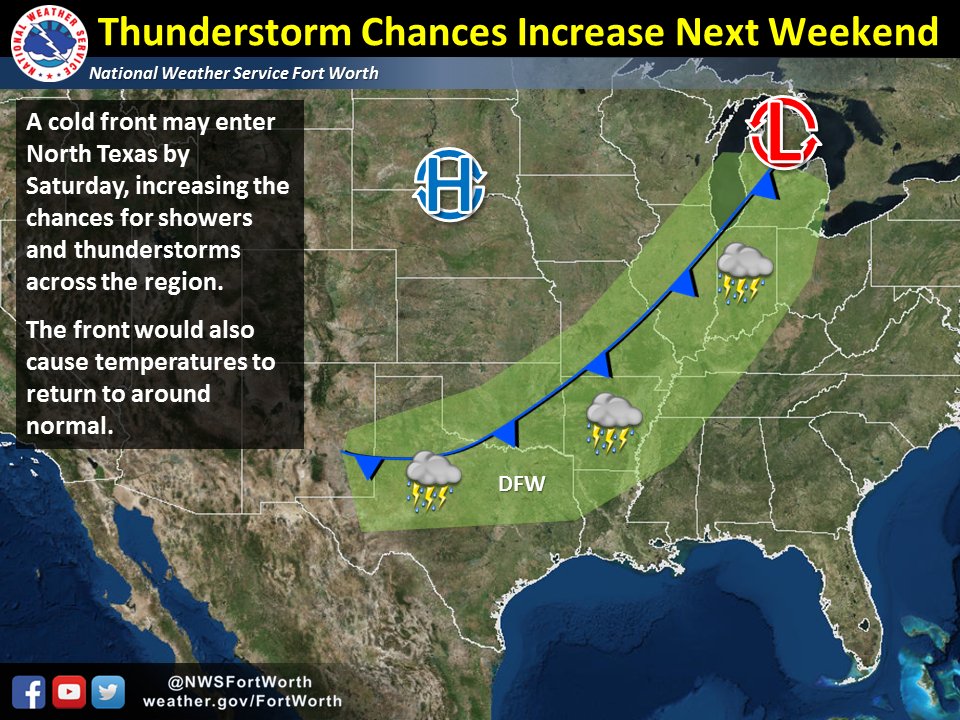
i will say this:. If 83-84 is an analog, a mid August cold front is certainly a possibility!
-
Who said summer was boring?
well, it was probably me. But I snapped an image of a dust devil at the intersection near my home.

-
The December 83 dump was so anomalous, it rivals the outbreak of February 1899. We could drive our cars across lakes.
http://www.srh.noaa.gov/fwd/?n=dec1983
http://www.srh.noaa.gov/fwd/?n=feb1899
-
35 minutes ago, bubba hotep said:
Starting to see some winter forecast here and there and they seem to jive with my thinking from a while ago. Avg to below avg temps and avg precipitation. The problem is that weak Nina with warm PDO equals not many true analogs. However, weak nina's in general are cooler than normal for Texas with '11-12 being the only weak Nina that was a true torch.
I was playing around with some numbers today. Doing some contour plotting of different indices. What I have found is it's the PDO. A positive PDO would override everything else except extreme circumstances such as last year's super Nino. I'll play with it some more as soon as we get the QBO and ENSO state squared away.
-
Greetings from the Dominican Republic! An easterly wave is supposed to drift in tonight and tomorrow. Hope to have some good pics!
-
Looks like another MCV forming off to the WNW.
-
Nice little swirl with this thing!

-
It's funny you bring up a wake low. I was looking at famous heat bursts earlier this week in anticipation of these storms.The eastward moving storms appear to have overtaken the outflow and are ramping up again. Also, maybe a meso/ wake low forming over Collin County?
-
Interesting V shape to the system.

-
Got visual on anvil off to my NW
-
We could use more rainfall in CLL, although not the massive electrical storm from last week. The heat index has been about 105°F+, but highs have not hit upper 90s yet. Agree the effects of the wet ground and overestimation of some of the ridging by NWS.
Yes. The soil is pretty much saturated. Actual temps don't really matter here because if it's 90, the humidity is insane. However the cloud cover from remnant storms combined with the moisture induced temps and southerly flow, makes this summer almost tolerable.
-
This zonal flow is singular. Amazed at the last two nights and looking at night three setting up.
-
Some nice natural fireworks headed this way. Night into day!

-
If those randomly spastic moving cells can form a cold pool and start pushing east then we might get something with this setup

You may be onto something. They seem to be getting their act together. Though they would pretty much have to head due east.
Last night's convection was a pretty rare event. Typically the only time we get nocturnal convection like that in July or August is with a warm core type system.
-
The DP is 76 and 90 T. It's pretty freaking hot.
-
Think you've got a shot.
-
I'm new to the San Antonio area. Recently transplanted from Detroit, MI. Gotta say I was unprepared for the heat and lack of interesting weather so far since I've been here. Didnt rain once since I arrived 6/5/16. Interesting to say the least.
Anyway, I look forward to posting in here when it does become more active.
Welcome! Trade snow for severe weather.
-
Spend a week with no power, no heat, frozen toilets, cooking on the fireplace and house bound because snarls of power lines are everywhere and you'll learn to hate ice storms.
-
Haha, Turnagain Arm winds are awesome. Classic true gap wind where, in SE flow, the air mass literally is blocked on the windward side of the very dense and large coastal ranges/Chugach Range, creating high pressure and accelerating down the inlet, reaching peak wind status at the end. It just so happens the end of the inlet is 5 miles SE of Anchorage, so the wind will go from 30 MPH to 90 MPH in literally less than 5 miles. You can see the Turnagain Arm in the image above with the graphics.
Thanks for the background. Always wondered why turnagain arm had the ridiculous winds. Alaskan weather is fascinating.
Don't know how it would be to think of 974 lows as the warmup act.
-
great googly moogly. From the NWS:
Saturday Night: Showers. Lows in the mid 40s to lower 50s. Southeast wind 35 to 50 mph with local gusts to 65 mph. Along turnagain arm and higher elevations...southeast wind 70 to 85 mph with gusts to 110 mph after midnight.
Sunday: Rain likely. Highs in the lower to mid 50s. Southeast wind 35 to 50 mph with local gusts to 65 mph. Along turnagain arm and higher elevations...southeast wind 70 to 85 mph with gusts to 110 mph.
Like how they casually throw in the "gusts to 110 mph". Pretty chuckle-icious.


Texas/New Mexico/Louisiana/Mexico Obs And Discussion Thread Part 8
in Central/Western States
Posted
God hates my yard