

Quixotic1
-
Posts
21,782 -
Joined
Content Type
Profiles
Blogs
Forums
American Weather
Media Demo
Store
Gallery
Posts posted by Quixotic1
-
-
January severe weather. Haven't seen measurable Snow in 22 months now.
-
January severe weather. Haven't seen measurable Snow in 22 months now.
-
4 hours ago, bubba hotep said:
It really held back that 2nd piece of energy. It feels like the 12z Euro and 18z GFS are at the two ends of the 500mb spectrum of possibilities for this event. Not based on anything scientific and just a hunch based off watching models the last couple of days.
Yeah. If we are getting into this weekend and things aren't settling on a solution it's going to be anxiety time. Anything hanging back is good news. Going to be patient. Going to go look at the euro now.
-
-
Get the cold. Worry about precip later.
-
3 hours ago, raindancewx said:
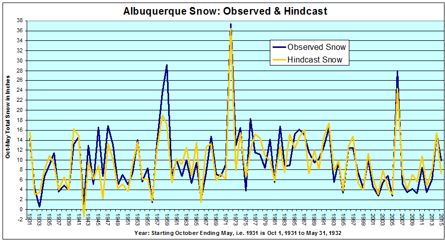
I was playing around with projecting seasonal snow totals for Albuquerque the other day, and I came up with six variables that account for ~78% (r squared = 0.78) of the variation in snow in a given Oct-May season here. They are hard to figure out, but have been asking people on Twitter, and they've done a decent job so far - quite close on first snow date. Essentially:
a) ONI in DJF (I used ONI estimates from 1931-32 to 1949-50 also)
") Precipitation in DJF
Precipitation in DJF
c) Mean High in DJF
d) Precipitation in August + Precipitation in October (as one variable - combined)
e) First measurable snow as a date (Oct 1 = 1, Oct 2 = 2, etc, measurable means >=0.1" snow in 24 hrs ending midnight)
f) Snowy Day Frequency (how many days had >=0.1" snow from Oct-May, day is 24 hrs ending midnight)
ONI has some effect on most of the other variables, particularly b, d, and f. Weak effect on c too. F is the strongest correlation to snow overall, but adding the other variables helps a lot, because you can have 10 days with each day averaging an inch...or two inches...or half an inch. Variable B/D have some control over frequency.
Generally:
A --> Strong relationship to total snow, and if the top month in the season is very snowy, i.e. El Ninos usually have one big snow month here, which leads to a big seasonal total.
B --> Reinforces/contradicts the frequency variable, and also adjusts intensity of that variable, i.e 15 snows in a winter with 0.70" precipitation won't be that great.
C --> Some influence on snow intensity on the days it snows, via snow ratios (15:1 more likely if cold?), and some influence on Spring snow likelihood.
D --> Lots of rain, lots of snow in Jan-Apr, especially March, and overall. March snow virtual lock if rainy. Little rain, snow shuts down fast after December. In between...can go either way.
E --> Literally an indicator of whether it snowed in November or not. Snow in November usually indicates a snowier than average Oct-May period. No snow by mid-Dec usually indicates average to below average snow. Roughly speaking, snow by Nov 10 - OK, first snow Nov 11 - 30 - Ideal, first snow Dec 1-14 - OK, first snow after Dec 14 - bad.
F --> More is better, but how much better depends on the other factors. With more snows, odds of a big snow from one system increase too.
An ideal snow season, according to the model, that is possible based on conditions that have been observed in the past 85 years for each of the six variables, would produce 47 inches of snow from October to May - would need a big El Nino, with early snow, lots of rain in August & October, lots of days with snow, a cold winter, and a wet winter.
The long & the short of this is some of the factors look **better** than last year despite the La Nina. We had an earlier first snow at the airport, and more rain in August & October. Both support more snow in the shoulder months (Nov/Mar) - it did snow a tiny bit in Nov. Suspect this is a colder winter than last year too which helps, as it probably won't torch in February for a third year in a row, and January looks average to cold, with December mild/warm.
This is what the hindcast v. observed discrepancies look like overall. Average error is +/-2.2", 87% shot at being within 4 inches in 85 years.
Nice work. I would recommend checking for overfit of your model. I've got some background for you if you're interested. I had a model at work that had a ridiculous r squared but was overfit. I did some digging around and found out the original data, unbeknownst to me, had been in triplicate. Creating overfit. Anywho, I'd be happy to take a look at it for you if you're interested. I think Judah Cohen and the Italian guys fell victim to it.
Cheers.
-
nice to see some west nao blocking......
-
Little anecdote from this morning: haven't been able to cut the yard because of travel, work and school but the grass really hasn't been growing. This morning I went out for firewood and there's a big dandelion about 2 feet tall. I thunked it and it broke like glass.
-
Little anecdote from this morning: haven't been able to cut the yard because of travel, work and school but the grass really hasn't been growing. This morning I went out for firewood and there's a big dandelion about 2 feet tall. I thunked it and it broke like glass.
-
41 minutes ago, bubba hotep said:
What kind of weather station do you have? I finally broke down and got a rain gauge but don't have an electronic temp station yet.
It's an ambient weather. I don't have a rain gauge. It does an accurate job on the temps. I verify it with a thermometer occasionally. It trends the pressure really well. I triangulated it from Denton McKinney and Addison. Did the same thing with the humidity. There are far less lazy ways to ensure accuracy but hasn't seemed to need it. I wanted a Davis but someone gave me this instead... been pretty happy.
The only thing I wish it could do is record daily highs and lows.
-
9 IMBY. Breaks the old record of 10 back in January 2015.
i expect it to be smashed tonight with lower winds and maximum cooling. This front reminds me of January 20, 1985.
-
1 hour ago, cheese007 said:
Where are you at?
North Frisco. I can literally throw a rock into prosper.
-
25 and light snow or drizzle falling here.
-
Since noon we've gone from 68 to 46. Impressive.
-
front is right on top of us. Changing from west to northwest winds.
-
1 hour ago, bubba hotep said:
12z Euro keeps DFW below 30 for the high on Sunday, unless it is above 30 after midnight. It is hard to tell exactly when DFW goes below 30 since it goes from 71 at 00z to 24 at 06z. Also, it kicks out the low and is much wetter than past runs but looks too warm for any winter weather.
so that's a drop off from 7PM to 1AM local time? Not unheard of. Hasn't happened in awhile. Christmas 2012 comes to mind.
-
FWD sounding bullish about this weekend. Essentially that even though moisture will be limited, the forcing as the base of the trough swings through will be very strong.
-
I don't know what the GFS is saying. It's all over the place.
-
So after looking at the recent guidance, one trend stands out. It seems to be a gradual but persistent "press" where the cold gradually sinks rather than blasts through. These patterns are awesome because once they set in they are slow to move. Even better we are on the fringe which means our precip chances go up. The last three days of the 00z GFS are fun to look at.
-
-
I got 29 IMBY.
According to the radio on the way in, Corsicana and Hillsboro were reporting snow.
-
12 minutes ago, aggiegeog said:
For some reason I really enjoy watching these type little events evolve on the models. It is a nice borderline system for wintery precip which is always a very tricky forecast. Hopefully some of y'all catch a couple flakes though most will likely be freezing drizzle though if the moisture is as deep as the models show ten maybe some flakes can make it to the ground.
I prefer them to anything. There aren't high expectations so I'm not chomping at the bit waiting for each HRR update. If we whiff who cares? It's when it's 48 out from a forecasted good event I freak.
-
It's probably overdoing the SE ridge.
-
pretty sharp west to east cutoff on that graphic!
Texas/New Mexico/Louisiana/Mexico Obs And Discussion Thread Part 8
in Central/Western States
Posted
I don't see how the models blow such a large signal like the wpo and the epo. Highly disappointing.