SBUWX23
-
Posts
1,292 -
Joined
-
Last visited
Content Type
Profiles
Blogs
Forums
American Weather
Media Demo
Store
Gallery
Everything posted by SBUWX23
-
Refresher snow & obs between ~midnight and Noon Sat Feb 17 2024
SBUWX23 replied to wdrag's topic in New York City Metro
Been thinking the same thing but seems to be differing opinions on this. Maybe east end isn't as great but think at least western half should be ok. Some south shore places may see more in this one than Tuesday. -
Refresher snow & obs between ~midnight and Noon Sat Feb 17 2024
SBUWX23 replied to wdrag's topic in New York City Metro
Look at radar. That band he said that reformed looks to be heading in the direction of the city. -
Refresher snow & obs between ~midnight and Noon Sat Feb 17 2024
SBUWX23 replied to wdrag's topic in New York City Metro
It's good official measurements are not taken on blacktop with a subway system below -
Refresher snow & obs between ~midnight and Noon Sat Feb 17 2024
SBUWX23 replied to wdrag's topic in New York City Metro
The dewpoint is 12. There will be no problem with snow fall on a colder surface once the steadier snow arrives. -
Refresher snow & obs between ~midnight and Noon Sat Feb 17 2024
SBUWX23 replied to wdrag's topic in New York City Metro
It's nothing probably radiaiting off the lowering clouds -
Refresher snow & obs between ~midnight and Noon Sat Feb 17 2024
SBUWX23 replied to wdrag's topic in New York City Metro
Probably won't take long for the park to drop below freezing. Not sure about blacktop in Manhattan. I'm sure there will be "roads covered" posts galore. -
Refresher snow & obs between ~midnight and Noon Sat Feb 17 2024
SBUWX23 replied to wdrag's topic in New York City Metro
I disagree. Temp is 37 now with a dewpoint of 12. When it starts precipitating temperature will drop to freezing and then should drop a bit more through the early morning. -
Refresher snow & obs between ~midnight and Noon Sat Feb 17 2024
SBUWX23 replied to wdrag's topic in New York City Metro
The dewpoint is 10 too. Ideal wet bulb cooking conditions -
Refresher snow & obs between ~midnight and Noon Sat Feb 17 2024
SBUWX23 replied to wdrag's topic in New York City Metro
No it did not looking at its simulated radar. -
Refresher snow & obs between ~midnight and Noon Sat Feb 17 2024
SBUWX23 replied to wdrag's topic in New York City Metro
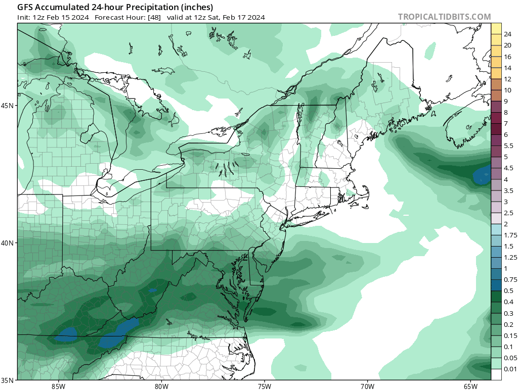
Makes no sense why N PA has more snow on this map then areas near the strongest frontogenesis -
Refresher snow & obs between ~midnight and Noon Sat Feb 17 2024
SBUWX23 replied to wdrag's topic in New York City Metro
Oh well. It's over then. Good night. -
Refresher snow & obs between ~midnight and Noon Sat Feb 17 2024
SBUWX23 replied to wdrag's topic in New York City Metro
Can you share what that means? -
Refresher snow & obs between ~midnight and Noon Sat Feb 17 2024
SBUWX23 replied to wdrag's topic in New York City Metro
This is just hysterical
-
Refresher snow & obs between ~midnight and Noon Sat Feb 17 2024
SBUWX23 replied to wdrag's topic in New York City Metro
temps may be just above freezing initially but Tds in the teens that will drop down once steady snow begins. -
Refresher snow & obs between ~midnight and Noon Sat Feb 17 2024
SBUWX23 replied to wdrag's topic in New York City Metro

-
Refresher snow & obs between ~midnight and Noon Sat Feb 17 2024
SBUWX23 replied to wdrag's topic in New York City Metro
This isnt an IMBY post but I feel like there is room on the NAM for a bit more of a push north too. -
Refresher snow & obs between ~midnight and Noon Sat Feb 17 2024
SBUWX23 replied to wdrag's topic in New York City Metro
what happenened? -
Refresher snow & obs between ~midnight and Noon Sat Feb 17 2024
SBUWX23 replied to wdrag's topic in New York City Metro
rgem is not that far off though. euro is not completely on its own. -
Refresher snow & obs between ~midnight and Noon Sat Feb 17 2024
SBUWX23 replied to wdrag's topic in New York City Metro
10m winds really are not N though. they are very weak. The issue is the energy is more robust on previous RGEM, Euro runs leading to a more organized low and a bit further north. New NAMs and FV3 are weaker overall and less precip on N side. -
Refresher snow & obs between ~midnight and Noon Sat Feb 17 2024
SBUWX23 replied to wdrag's topic in New York City Metro
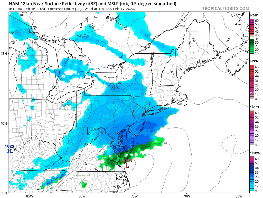
this is just one variation in CNJ, but NAM3k is showing it above the dendritic growth zone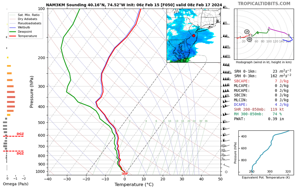
-
Refresher snow & obs between ~midnight and Noon Sat Feb 17 2024
SBUWX23 replied to wdrag's topic in New York City Metro
try to look where omega is located, and see if it lines up with the -12 to -18 zone in the profile and it is saturated. That is also one piece of the puzzle. Snow habit is diverse, but that is one way to get an idea. -
Refresher snow & obs between ~midnight and Noon Sat Feb 17 2024
SBUWX23 replied to wdrag's topic in New York City Metro
the big unknown is if snow growth isnt the best, if you are not dendrites the habit could lower your ratio even its cold. Temperature is only one part of the equation. -
Refresher snow & obs between ~midnight and Noon Sat Feb 17 2024
SBUWX23 replied to wdrag's topic in New York City Metro
The nam can easily shift back north. Rgem is and it's consistent with its previous run -
Refresher snow & obs between ~midnight and Noon Sat Feb 17 2024
SBUWX23 replied to wdrag's topic in New York City Metro
Wanna see this continue in next several runs. It's been back and forth but would be cool if we can get a bump in qpf too -
Refresher snow & obs between ~midnight and Noon Sat Feb 17 2024
SBUWX23 replied to wdrag's topic in New York City Metro
Seems like the type of system that would trend north down to the wire. Just speculating there though and by no means saying it will happen. Just feel like I've seen northern stream dominant lows shift north frequently.