

1234snow
-
Posts
1,727 -
Joined
-
Last visited
Content Type
Profiles
Blogs
Forums
American Weather
Media Demo
Store
Gallery
Posts posted by 1234snow
-
-
Poor Chattanooga is right in the edge of the line. If precip could fill in to the southwest of them it would probably be close to turning to snow.
-
 1
1
-
-
Should be go time for Chattanooga and surrounding areas now. Precip is starting to break out.
-
1
-
-
Light snow band has extended from Nashville to middle Alabama/Mississippi. Some radars pick it up. Some don’t. Curious to see if it is reaching the ground?
-
3
-
-
Well, time to go running...this is gonna be a slog. Moderate rain. Been trying to get up the nerve or about two hours. LOL.
Save the run for tonight when it’s snowing!!!!!-
1
-
-
Very heavy rain band of 55 dbz moving thru now. Heavy rain all morning. Quite the impressive system alone based on the rain. Current temp is 49.
-
One observation I will make is that the line of convection seems to be advancing to the East very quickly. Hopefully that can slow down somewhat.
I’ve seen in many cases in the past where the line of convection can race ahead east of the mountains and cutoff the flow coming off the Gulf. That is where the Lee side low would help us out.-
4
-
-
3k looks great through 30 for most of ETn
.
Both the 12k and 3k look awesome to me. Snow maps haven’t loaded yet on Tropical Tidbits.
Keep backin'er up!Back it up, Terry! Put it in reverse!
-
5
-
-
Always like it when the airmass is so cold, you can see it in IR satellite during the day:
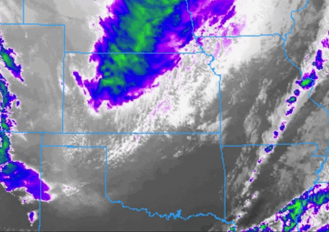
Grays that look like clouds sliding through SE OK, but there are no clouds, just cold:
Front is popping some convection now too, over central AR: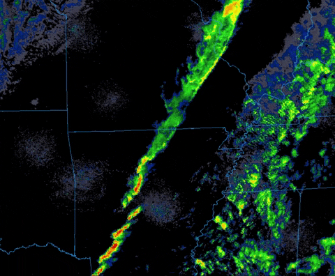
and speaking of lapse rate snow showers, they look pretty healthy in the upper left of that gif, over KS
Not sure if this system will fit the definition of a “Blue Norther” for those folks in Texas/Oklahoma but it is certainly dropping due south.
You can really see the orientation of the trough well in those animations.-
2
-
-
I feel we have many changes still left to go. My guess would be a more amped final solution.
-
1
-
-
One thing I’ve noticed and it has been mentioned here already is the 500mb trough has been trending sharper and further south. That backside energy really wants to shoot south. That can only help us out I would think. May even pop another low that the SREF is eyeing.
-
1
-
-
12z RGEM was very wet with a changeover at the end. My phone won’t upload the maps though.
-
I know that our focus is the snow but check out the 2m Temp anomaly on Tropical Tidbits from the 12z GFS. Wild watching the cold front plow thru the Gulf of Mexico and Southeast states. One thing seems to be guaranteed is that this is a potent cold shot.
12z GFS was a fun run in general. Plenty of opportunities to track on that run after Christmas storm.-
2
-
-
Nothing at all here. Mostly light rain with maybe some flakes mixing in. Down to 35 now.
Micro climates can suck. Get downsloped in every direction possible. Warm pocket always stays here the longest and the precip gets eaten away.
Congrats to all on a nice start to the season.
-
3
-
-
Very surprised that MRX has accumulating snow wording already for a system next week. That is a rarity for sure.
I hope that everyone has a great Thanksgiving! I’ve been reading and lurking in the background.
Pleasantly surprised that we already have multiple chances to track over the next few weeks. I did not expect that at all. I figured we would continue the wall to wall warmth straight out of our warm fall into most of winter with minimal cold shots.
The atmosphere seems to be acting like a Nino instead of a Nina for the next few weeks. Give me some high latitude blocking potential, +PNA, and an active subtropical jet and we will surely score one hit in December.-
4
-
-
Very cool the last few mornings. I didn’t happen to look at what the records are but low 40’s feels really darn cold to my body this early lol.
-
2
-
-
It was pretty wild...felt like I was watching storms out West. Vivid stuff! Looked like quite a boomer up your way with that last storm.
There was a good wind storm last week but I was out of town. -
Lots of rain IMBY yard this evening - very thankful. Looks like more on the way tomorrow. Will take every drop right now!
Radar estimated about 1.5” here. Quite the lightning display!-
1
-
-
Couplet has intensified in KY northeast of Pineville:

-
1
-
-
Finally the KY storm is tornado warned. I got -91mph on the last RadarScope scan.
-
TDS
edit: to add update51 PM CDT SAT APR 25 2020 ...A TORNADO WARNING REMAINS IN EFFECT UNTIL 515 PM CDT FOR CENTRAL SMITH COUNTY... AT 450 PM CDT, A CONFIRMED TORNADO WAS LOCATED NEAR I-40 NORTHEAST OF WATERTOWN, OR 8 MILES SOUTHWEST OF CARTHAGE, MOVING EAST AT 35 MPH. HAZARD...DAMAGING TORNADO AND QUARTER SIZE HAIL. SOURCE...RADAR CONFIRMED TORNADO.
Just crossed I-40 minutes ago. An area that certainly doesn’t need another tornado this year.
-
Tornado warned storm east of Lebanon/Nashville is moving along I-40 with possibly a couplet developing:

-
Etowah storm report of 1.75” hail (golf ball). If in the path northeast of there I would certainly cover vehicles if possible.
Appears Tellico Plains will get squeezed in between the 2 cells. Also a warned storm on the plateau. -
Closeup:

-
Have our first severe warned storm with up to 1” hail working into Etowah and up the southern portions of the Valley.

Christmas Eve/Christmas 2020 Arctic Express Snow Obs.
in Tennessee Valley
Posted
Intense wind and rain here. Power has went in and out already. Temp from 50 to 41 in a matter of minutes.