

oconeexman
-
Posts
2,043 -
Joined
-
Last visited
Content Type
Profiles
Blogs
Forums
American Weather
Media Demo
Store
Gallery
Posts posted by oconeexman
-
-
5 minutes ago, NCsandhills said:
Lots of reports from Ral in this thread of heavy snow and folks saying almost an inch and I'm just like ????? Am I in literally the worst spot? It's barely snowing here in the heart of Raleigh and certainly not sticking to pavement, although it is sticking to cars, roofs and grass it is nowhere near an inch. Not in my neighborhood lol. I'll take my measuring tape out in 30 mins after dinner is going. My garbage cans have been out all day so the tops should roughly reflect how much snow has accumulated on cold surfaces.
That ain't happening
-
Just now, Andersonwx said:
I live by the Anderson airport and I just got back from Westminster. It's crazy seeing it snow here in western Anderson and a mix in Oconee County
Yea that doesnt happen often for sure! Enjoy it down in LA
-
 1
1
-
-
Still an ugly old mix here..literally snowing all around me..even in Anderson
-
3 minutes ago, lilj4425 said:
34 now with heavy snow.
Good for you turd...lol
No congrats really...hopefully Mack gets some as well
-
2 minutes ago, palmettoweather said:
Big flakes here as well now, but still 37. Not gonna stick like 2/8.
Down to 35 here
-
1 minute ago, burrel2 said:
Parachutes mixing in here now, I can literally look up in the sky and see a massive blizzard beign swept in the wind a few hundred feet off the surface. Come on down already!!!!
Same here..best flakes yet and I'd say 60/40 snow
-
 1
1
-
-
Just now, NEGa said:
Some pretty flakes starting to mix in here finally
Nice...hopefully your area can complete the changeover. It been a battle here for over an hour. Almost .3" qpf down the gutters. Although all indications were I was screwed from the get go
-
Man it wants to switch over bad here but dont think it will. Got a lot of flakes mixed in now..back and forth. Wish I didnt like this crap but I do
-
 1
1
-
-
5 minutes ago, burrel2 said:
Can't believe the surface boundary layer is this deep when we just had sleet and mesoanalysis showing 925mb temps below -1C.
I know this is a wierd one hear. Now getting some sloppy flakes mixing in
-
Back to a mod/heavy rain now..wtf
-
1
-
-
Got a nice mixed bag here now..I hooked up some of that cold at the state line and drug it down the hill with me.
38 deg currently
-
4 minutes ago, burrel2 said:
A few wet snowflakes splattering the windshield in clemson
You will appreciate this..drove up to fish hatchery..solid mix from Last Chance up.
When I got to cherry hill was 32 deg and all sleet..crazy
-
1
-
-
39 and all rain..gonna take a ride and find it
-
17 minutes ago, strongwxnc said:
43/22
snow is falling. No rain rain just snow.
Hell yea!! Happy for ya brother
-
1
-
-
9 minutes ago, NEGa said:
are you getting snow right now? I in Habersham and multiple people have said it was snowing pretty good in clayton now
here it is raining and 38
 lol
lol
This one is a kick in the gut...punished for the last over performer I guess! I'd expect u to changeover before noon at your elevation though.
-
1
-
-
Currently snowing fine clear flakes...nope that's rain
43.5 and crappy..these never work out here and virtually no model has it working out here. But man I'm pulling for some good peeps on here that deserve it and have been left out this year!!
-
 1
1
-
-
Just now, mackerel_sky said:
TR gets 4”+, no school Friday Greenville County, calling it now!
I wouldn't bet against that at all
-
1
-
-
Lord I hope the Hrrr scores on this one..to watch it rain all day will be painful
-
12 minutes ago, WarmNose said:
Motel 6 in Landrum still got any availability?
Lol I guarantee Landrum gets snow
-
1
-
-
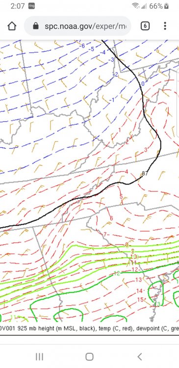
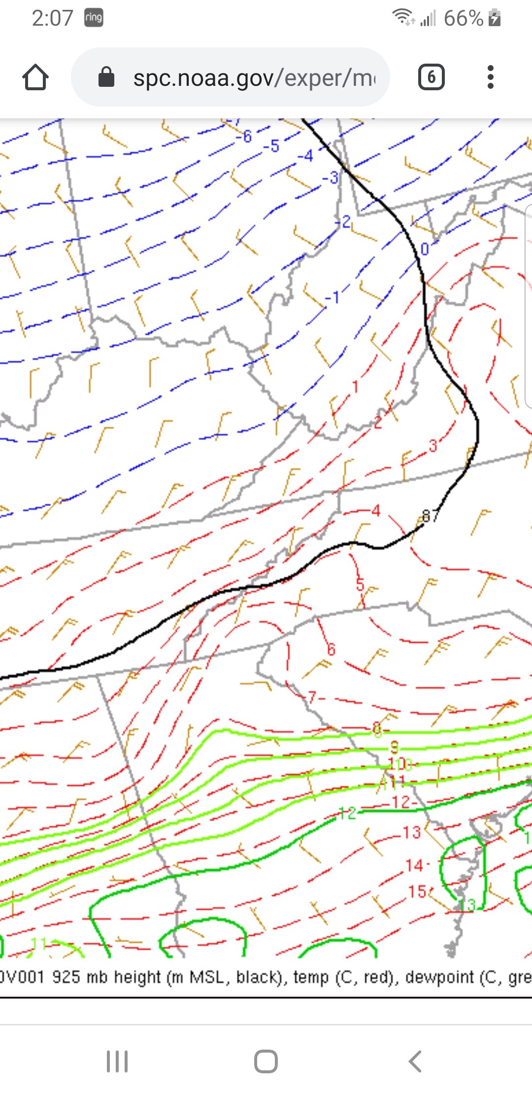
Look at that warmth in Ne Ga and Nw Sc
Ouch
-
2
-
-
28 minutes ago, burrel2 said:
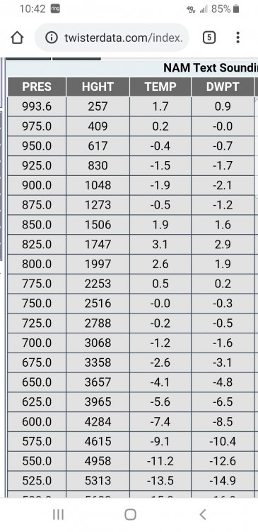
Gonna come down to nowcasting for the northern upstate of SC. The HRRR and ARW both have my location's sounding going isothermal around 10am just as the heavy axis of precip moves in. The HRRR keeps surface temps at 34-36 though which would be an issue, but I'm guessing it has it's typical bias at play here.
On the other hand, the 3km NAM has the warm nose holding strong until 1-3pm for the northern upstate. It shows surface temps at 32-33 however.
If, if.... somehow the HRRR and ARW thermal profile is right then the northern upstate could get a 4 to 6 inch past job tomorrow as the heaviest rates come through between 10:00am and 3:00pm. If the 3km NAM is right, then we're going to see a lot of rain/white rain/sleet mix with a possible burst of moderate snow as the back edge swings through with little to no accumulations.
It's all comes down to that 800mb warm nose, (and possibly surface temps even if the warm nose is overcome).
I would be really nervous in the Raleigh area as it looks like the warm nose will most likely push in to that area during height of the storm. Also I wouldn't bank on the precip outlasting the nose on the backside there. Whoever stays just to north of the warm nose push in that region is going to get 6-10 inches. Whoever is just to the south of it is going to be extremely disappointed. My best guess is Southern Wake gets 1-3 inches of snow/sleet from the storm will the northern end of the county gets the jackpot.
Thanks burrel2 for your thoughts. Nam has been on a roll here but I'm rooting against parts of it's over amped solution!
-
6 minutes ago, StantonParkHoya said:
That’s reflectivity, not the rain snow line.
That's some really poor analysis...
Hrr looks great..very Nam like but colder.
-
1
-
-
Looking forward to some insight from brother Lookout for this area. Still think above 85 in upstate gets a nice event if anything close to the nam and gfs pan out.
-
1
-
1
-
-
This is no bueno
-
1
-
Mid to Long Term Discussion 2020
in Southeastern States
Posted
Meh another rain maker then more cold. Weak disturbance 29th-1st that has possibilities. Looks like some decent upslope for the mountain folks coming up. Long range def has some cold air shots though. Was hoping to see another before I hit the road in March for work. But will see some snow on the banks of Lake Ontario for sure!