ncjoaquin
-
Posts
1,440 -
Joined
-
Last visited
Content Type
Profiles
Blogs
Forums
American Weather
Media Demo
Store
Gallery
Everything posted by ncjoaquin
-
2025-2026 Fall/Winter Mountain Thread
ncjoaquin replied to Buckethead's topic in Southeastern States
Good assessment. Still enough moisture for something. A dusting would be a win. -
2025-2026 Fall/Winter Mountain Thread
ncjoaquin replied to Buckethead's topic in Southeastern States
I haven't given up yet, but that sounds about typical. Still hoping for a surprise. -
2025-2026 Fall/Winter Mountain Thread
ncjoaquin replied to Buckethead's topic in Southeastern States
42.8 here and falling fast. -
2025-2026 Fall/Winter Mountain Thread
ncjoaquin replied to Buckethead's topic in Southeastern States
Maybe why GSP is not very excited, or really at all for Buncombe. I hope that they are wrong. -
2025-2026 Fall/Winter Mountain Thread
ncjoaquin replied to Buckethead's topic in Southeastern States
Finally, an over performer on rain. .97 in the rain gauge with maybe a little more to go. Very welcome rain! -
2025-2026 Fall/Winter Mountain Thread
ncjoaquin replied to Buckethead's topic in Southeastern States
Wow!! That really is impressive. Looks beautiful! -
2025-2026 Fall/Winter Mountain Thread
ncjoaquin replied to Buckethead's topic in Southeastern States
It has. NWS on the money. -
2025-2026 Fall/Winter Mountain Thread
ncjoaquin replied to Buckethead's topic in Southeastern States
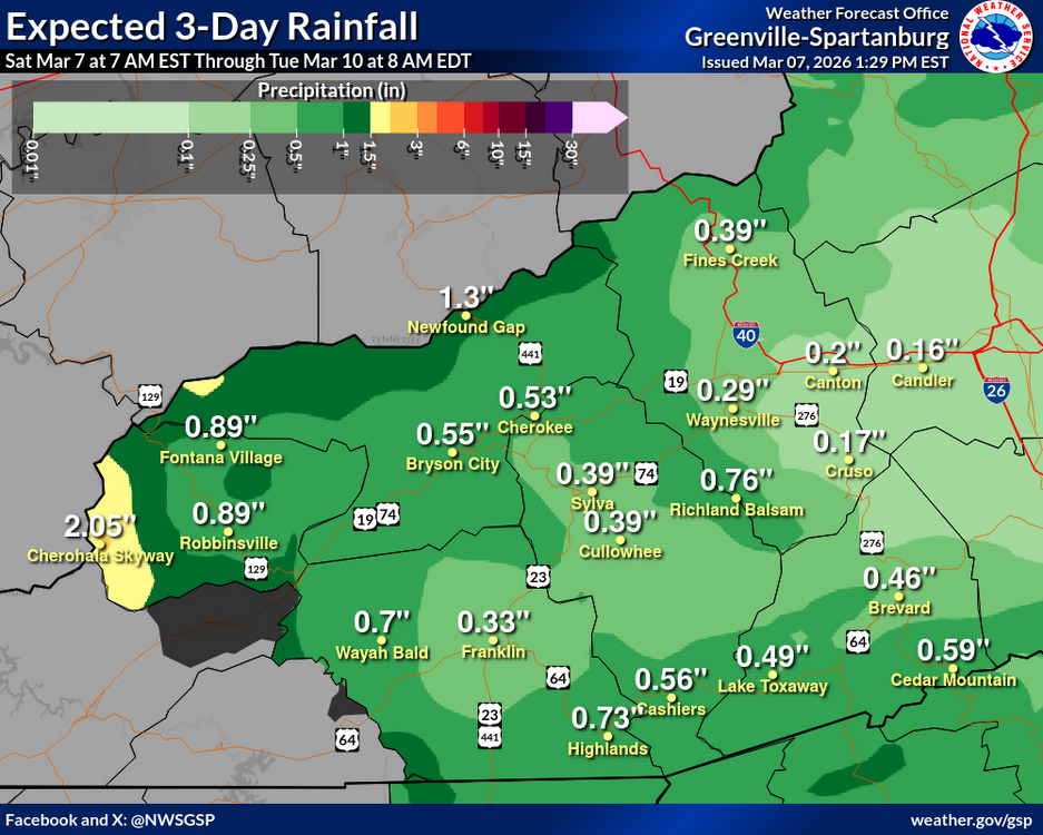
NWS forecasting .16 inches for Candler for the next 3 days. Already had .33 yesterday. Hard to believe this line will just produce .16 inches of rain.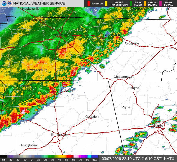
-
2025-2026 Fall/Winter Mountain Thread
ncjoaquin replied to Buckethead's topic in Southeastern States
I am at 11 inches. Not great, but way better than it's been. Plus, I made it to zero degrees. Still time for one more hurrah. -
2025-2026 Fall/Winter Mountain Thread
ncjoaquin replied to Buckethead's topic in Southeastern States
I understand the specific category that is necessary to issue an advisory. I am certain that was met in many parts of Buncombe. We had roughly an inch here at my house. My daughter sent a picture from Arden that looks like 2 inches . I think they need to change their criteria. If the roads are slick and schools are closed, to me that warrants a winter weather advisory. It's winter weather and people need to be advised. But, what do I know, lol. -
2025-2026 Fall/Winter Mountain Thread
ncjoaquin replied to Buckethead's topic in Southeastern States
No idea how much snow, but it is pouring. Everything is white including the roads. 19.0 degrees. -
2025-2026 Fall/Winter Mountain Thread
ncjoaquin replied to Buckethead's topic in Southeastern States
A little AFD GSP snippet for you higher elevation guys. You may get your own blizzard. " NBM accums were quite a bit higher than last night with some areas in the smokies and near Roan Mtn approaching 20". Pulled back on those amounts given the shallow moisture but considering 50kt winds at 850mb tonight plus multiple rounds of DPVA spinning around the larger vort lobe, would not be surprised if some areas outperform the current forecast. -
2025-2026 Fall/Winter Mountain Thread
ncjoaquin replied to Buckethead's topic in Southeastern States
To add to the above for Asheville, NWS has an official forecast of 0, with a high end of 2 inches. -
2025-2026 Fall/Winter Mountain Thread
ncjoaquin replied to Buckethead's topic in Southeastern States
1/2 inch to an inch seems possible. Maybe more if you luck up and end up under a heavier snow shower. -
2025-2026 Fall/Winter Mountain Thread
ncjoaquin replied to Buckethead's topic in Southeastern States
GFS shows a pretty impressive NW flow event. Let's see if it holds. -
2025-2026 Fall/Winter Mountain Thread
ncjoaquin replied to Buckethead's topic in Southeastern States
All the talk of big rain . Only .13 here at my house. Glad this wasn't snow! -
2025-2026 Fall/Winter Mountain Thread
ncjoaquin replied to Buckethead's topic in Southeastern States
Surprisingly made it down to 21.0. Just like every rainfall for the last 6 months, the expected amount has trended down all week. Hopefully, I can pull out a half inch of rain. We need it! -
2025-2026 Fall/Winter Mountain Thread
ncjoaquin replied to Buckethead's topic in Southeastern States
From Jason Boyer- AVL Regional Airport just had a gust of 63 mph!! -
2025-2026 Fall/Winter Mountain Thread
ncjoaquin replied to Buckethead's topic in Southeastern States
The wind here is absolutely stupid already. It is going to be a long night. -
2025-2026 Fall/Winter Mountain Thread
ncjoaquin replied to Buckethead's topic in Southeastern States
Me neither, but all it takes is that rogue snow shower to throw down a quick 1/2 inch to an inch. Wishful thinking..... maybe. -
2025-2026 Fall/Winter Mountain Thread
ncjoaquin replied to Buckethead's topic in Southeastern States
Halfway decent snow falling. It has whitened the cars and my deck. -
2025-2026 Fall/Winter Mountain Thread
ncjoaquin replied to Buckethead's topic in Southeastern States
I did not. I would be shocked to wake up to 2 inches of snow. I am not expecting it, but it would be a nice surprise. Thanks for posting. -
2025-2026 Fall/Winter Mountain Thread
ncjoaquin replied to Buckethead's topic in Southeastern States
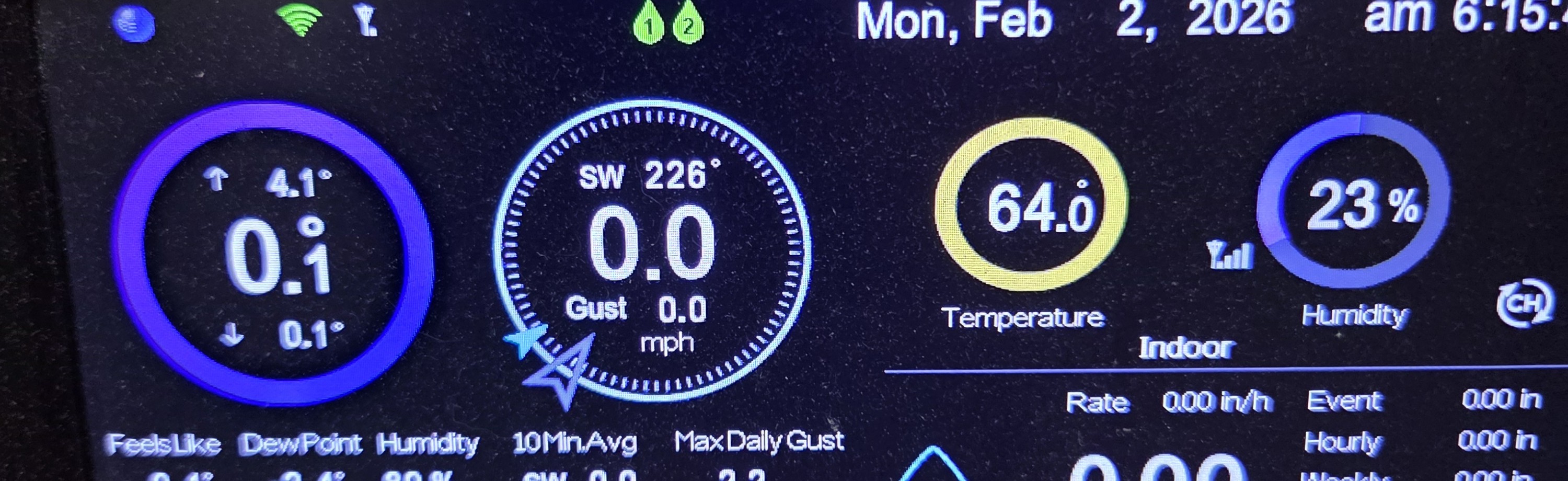
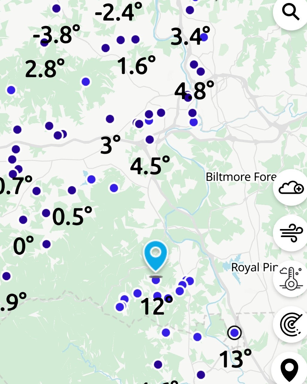
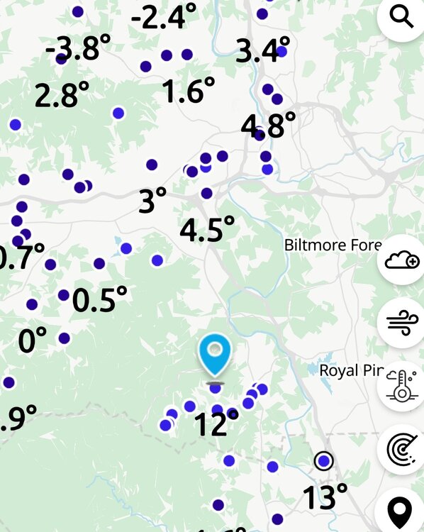
I am at .1. The airport is at 13!!! What the heck? Downtown is at 7.2. Edited to add. I have changed these a couple times because downtown and my house have continued to drop, while the airport stays about the same. One more edit. It might go lower, but the lowest in a while. I figured I would show it. Cold!! And one more edit to show it's not just me. The 13 is the airport. The others are also from the Ambient network.
-
2025-2026 Fall/Winter Mountain Thread
ncjoaquin replied to Buckethead's topic in Southeastern States
About 7 inches total. Not an all timer. But....... I still agree with the A+ ! I love the super cold snowstorms. It was a beautiful snow. It snowed all day long . It hasn't immediately melted, and probably won't for a while. Plus, at least here, there has not been a lot of snow since January 2022. So, an A+ is the only grade that makes sense. -
2025-2026 Fall/Winter Mountain Thread
ncjoaquin replied to Buckethead's topic in Southeastern States
Thanks man! I wish you could be here for one.