

forkyfork
-
Posts
30,326 -
Joined
-
Last visited
Content Type
Profiles
Blogs
Forums
American Weather
Media Demo
Store
Gallery
Posts posted by forkyfork
-
-
55 minutes ago, SnoSki14 said:
Nicest day in weeks. Tomorrow looks awesome too then things go downhill.
Next weekend looks yuck. Multiple highs in 50s lows in 30s. Frost/freeze potential in colder areas probable.
I guess it could be worse. I've seen highs in the 40s for May before.
may 2005 was a dumpster fire
-
-
Just now, Stormlover74 said:
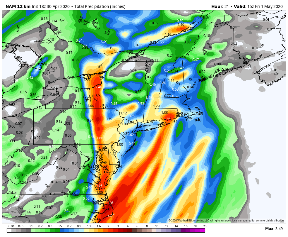
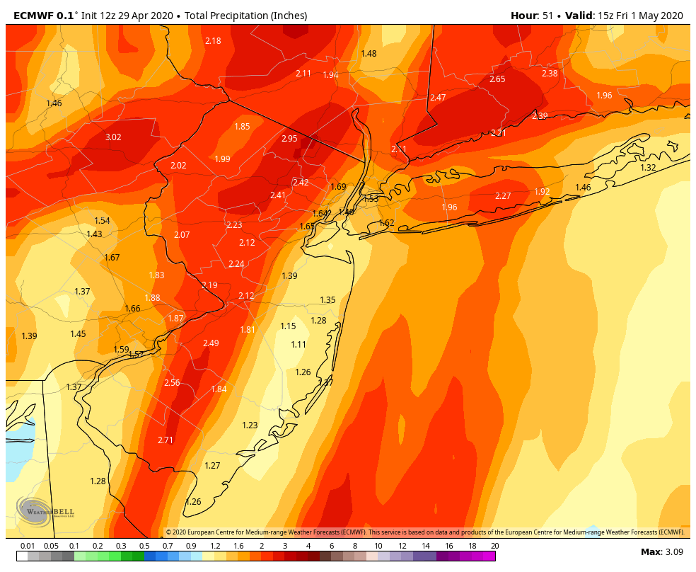
Rgem cut way back too. Mostly .5 to 1"
some spots might get that with slow moving shallow convection tomorrow
-
a good portion of that is from convection tomorrow
-
 1
1
-
-
6 minutes ago, LibertyBell said:
subsidence area between two heavier bands? thats where we usually end up in snowstorms lol.
the bowing out of the line south of us leads to less training
-
1
-
-
47 minutes ago, Allsnow said:
GFS FTW?

most models screw over e nj
-
1
-
-
30 minutes ago, Allsnow said:
No you don’t....
-
2
-
-
2 minutes ago, LibertyBell said:
it's not really a bust when you consider that this is what these kinds of storms usually do. More rain west / more wind east.
NYC/LI 1-2" of rain and 50 mph gusts.... western NJ/PA 3-5" of rain and 30 mph gusts
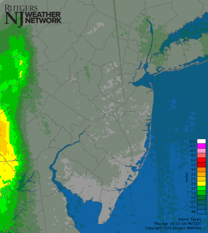
there are places that will wind up with under an inch in nj
-
1
-
-
this is looking like a bust for most east of far western nj
-
3
-
-
16 minutes ago, Allsnow said:

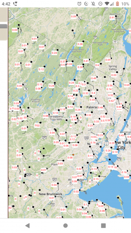
we won't know where the 2+" banding sets up until it happens
-
4
-
-
56 minutes ago, Stormlover74 said:
But euro was 3"+
it's going to come down to bands of training which will have to be nowcasted
-
2
-
-
the ukmet is like the euro

-
1
-
-
impressive tropical moisture connection with the next system

-
1
-
-
may 2005. after that the switch flipped and we had one of the hottest summers on record

-
1
-
-
2 minutes ago, gravitylover said:
That's better than 7 months of April
you snow people are mentally ill
-
1
-
 1
1
-
 1
1
-
-
7 straight months of november
-
1
-
2
-
 3
3
-
-
i hope there's never a freeze warning again
-
1
-
-
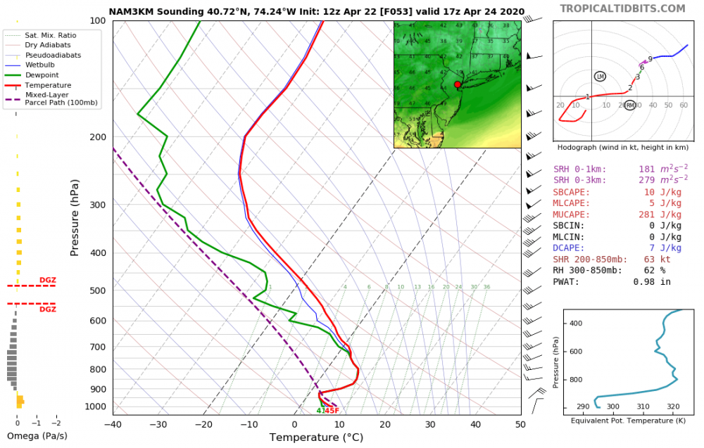
what a dumpster fire sounding for friday afternoon
-
2
-
-
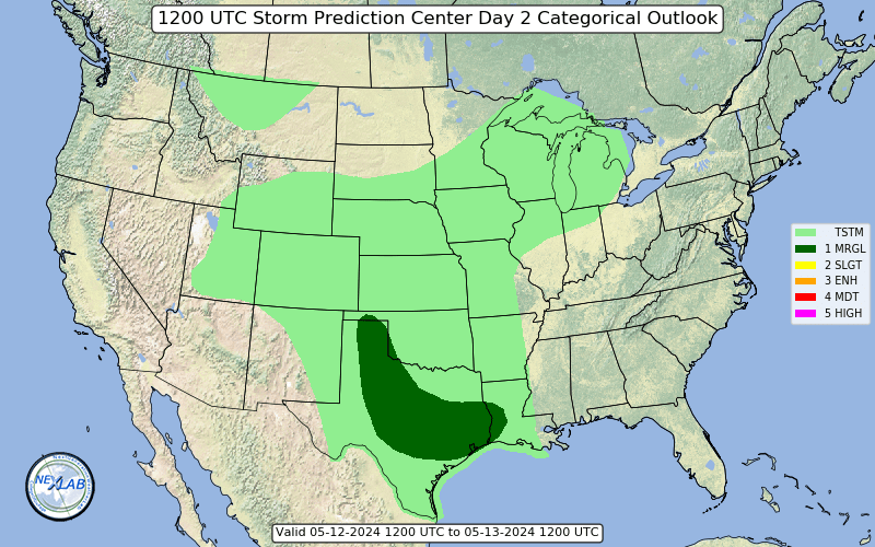
upgraded to slight risk
-
2
-
-
this would have produced a mecs/hecs 2 months ago

-
1
-
2
-
-
a south trend is good news. nobody needs snow on top of what's happening already
-
1
-
2
-
 1
1
-
 1
1
-
-
is there really a wind fight going on in the april thread
-
1
-
3
-
-
i'm usually skeptical of these south wind events but the velocities are so intense you barely need any mixing for good gusts
-
1
-
-
ewr 47 mph gust


COVID-19 Talk
in Mid Atlantic
Posted
aww look at all the bored white guys and their magical thinking