

buckeye
-
Posts
8,772 -
Joined
Content Type
Profiles
Blogs
Forums
American Weather
Media Demo
Store
Gallery
Everything posted by buckeye
-
gfs and gem still north with the mon clipper. A lot depends on the orientation and how the PV rotates as the storm rides around the edge out of the north central states. Still a lot could change in 5 days, and the old 'bullseye' rule applies. That's one hell of a brutal air mass on it's heels. I'm having a hard time believing it's going to cut up towards north east OH with that air mass.... but of course that's probably the weenie in me talking.
-
no, but in fairness euro still has til monday to verify In the meantime, that monday clipper jumped pretty far north on the modeling overnight Still time to change, especially considering there are two smaller back to back systems in front of it.
-
Both the 18zgfs, and fv3 both trended significantly south with the monday clipper. Euro is still north but I bet it also comes south. It would be unusual for such a strong clipper to go through northern OH, especially this time of year with the PV so far south.
-
Looks like some nickle and dime'n over the next week -I'd still keep an eye out for some backside lov'n, (no sexual inuendo intended), possibly thursday night. Wouldn't be surprised to see that come a little further west. Wouldn't be a biggie, but might be good enough to cover the grass back up after we lose the snow cover from the rain. -Then a possible weak system over the weekend, (ggem most bullish on that one) -Then a stronger clipper Monday timeframe, (models want to take that north of us but should watch for a south trend).
-
Low 960s is pretty uncommon,,even on rogue ensemble runs.
-
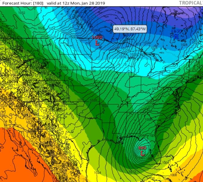
supposedly 990 would be the lowest mslp in the gulf (in winter) since March 93.
-
another time frame to watch for is day 7-9. No specific storm on any of the ops but the upper air pattern is explosive. A strong piece of energy rotating south around the PV while the southern stream tries to develop a strong system in the gulf. If those phase, and it's at the right time, that would be a monster somewhere east of the miss. and it would probably drive the pv further south. I'll be curious to see the euro ens. GEFS has a few biggies. (one shows a 962 low driving north into southeastern OH). That's amazingly close to what the '78 featured. Icon showed something close last night. The low in the gulf is 990, which is pretty incredible for this time of year. Blizz of 78 and superstorm 93 both had similar set ups, but timing differences with the phase.
-
Indy area surprises me, I was under the impression that they got slammed.
-
Hard to measure, but after a drive around ....5-6".... Jay? This had a huge local variability with snow amounts probably due to the convective nature. There were areas where it looked like they got 8 or 10 inches and only a couple miles away, maybe 3 or 4. Curious what you central Ohio guys think on amounts in your back yard.
-
Its closing in
-
I didnt
-
-
Have you seen radar....incoming pound town.....
-
Wait til I write my rant tomorrow...with a hangover,too
-
Snows,mixing too finally
-
I talked myself out of it snd should have known better. A low tracking into w.TN from the SW is,usually the kiss of death.....but....we had a pushing Arctic front and every model, (led by the unwaivering king itself), telling us no worries... All that said, let's see where we are with this tomorrow before writing obits.
-
Just insane. There must be pockets of warm air in the upper levels. Dilly, holy sh@t, I can't believe you're still getting sleet. You must be an island. The snow,is mixing at times here and,we have freezing rain, but I think it's gonna get crazy pretty soon. Calling for 45mph winds. I've seen 2 cars drive by the house totally covered in snow.
-
Was out driving in Westerville . rain, sleet, slush drops.
-
Freezing rain in Westerville starting to ice up trees
-
Lots of 'weatherman' slamm'n going on .... poor guys ...they better hope this deform band works out
-
probably best at this point to turn off the models and start looking at actual obs and radar. Speaking of which, we have a lot of steady precip coming in from the southwest, will be interesting to see what it ends up being
-
I'm not throwing it in until everything is passed us. I can't imagine the HRRR or any model is going to handle the details of the deform band perfectly.
-
jbcmh, you are probably more right than me. Newest HRRR says snow arrives to Frankling county pretty quickly as in like 6ish
-
Sleeting now in Lewis Center....
-
yea wish we had a Dublin poster checking in


