
Radtechwxman
-
Posts
2,099 -
Joined
-
Last visited
Content Type
Profiles
Blogs
Forums
American Weather
Media Demo
Store
Gallery
Posts posted by Radtechwxman
-
-
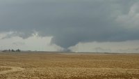
Hopefully won't get in trouble for posting this. Winds aloft not looking as westerly as before. Jet has more amplitude this time around and not as flat
-
2 minutes ago, bjc0303 said:
What... 12z hasn’t started lol
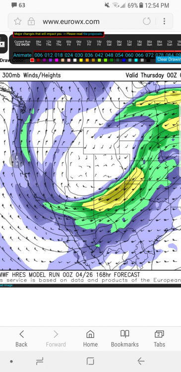
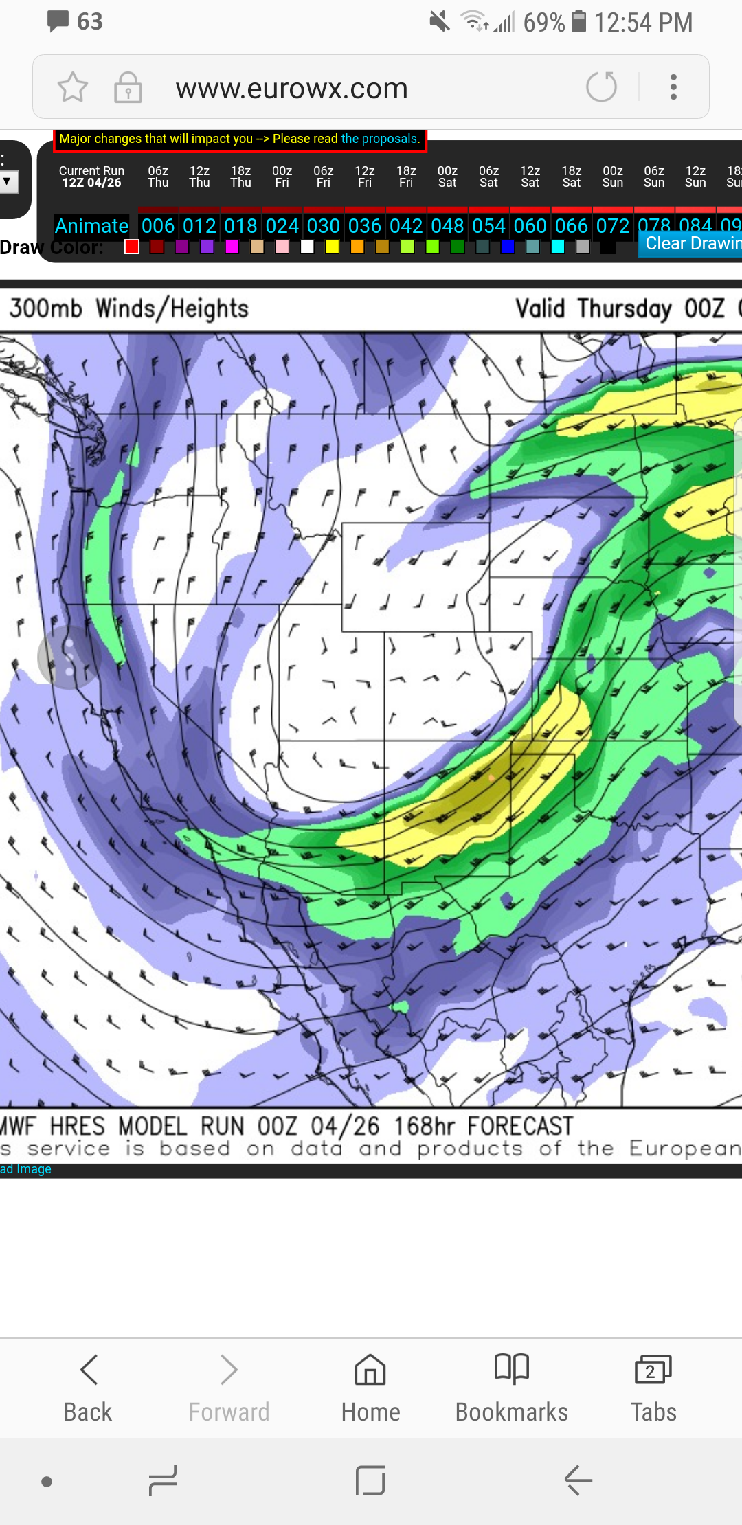
I have eurowx. 12z run is out through Wed now
-
Well 12z euro took a step in the wrong direction. Hopefully just a bad run and not a trend. Looking more GFS like
-
Yea GFS is all over the place. Euro has been holding relatively consistent. 12z gfs has no surface wave on Wed now and really lags the upper jet behind mostly likely cuz it has more amplitude then euro. Hopefully it caves eventually
-
1 hour ago, jojo762 said:
Wednesday verbatim on the euro is easily the best setup we've seen YTD, which isn't saying much, but nonetheless still impressive. 70-80kt bulk-shear atop 2000-4000J/KG CAPE, juxtaposed to more-than-sufficient turning and speed in the lowest 0-3KM.
Couldn't say it better myself. And it has a nice tight sfc low which is deepening in that classic spot near the panhandles and se CO. Great turning like you said. If euro is right Wed def could be one of the bigger days in recent years in the southern Plains. And love that it is showing it in the better terrain near and west of I35
-
Yea it's been tough to get some westerlies aloft the last several years. Slow moving meridional BS. So would be fantastic to see a lower amplitude trough for once
-
0z gfs very impressive. Esp on Wed. To me seems to be trending towards Euro like solution. Upper levels still more southerly than I prefer but still far out and plenty of time for improvement. Def a step in the right direction
-
I still think Tues-Thurs have a decent risk of severe weather. Obviously depends on evolution and timing of trough but overall seems like a setup for a few chase days. After this we look to see a lull again into mid month and then possibly ramping up mid to late May again
-
 1
1
-
 1
1
-
-
Thanks for posting those man! Appreciate it. That is gorgeous! Nice low amplitude broad based trough. I know andyhb is a fan of those
") and I love that it looks like another trough is loading in the SW behind it. Kinda reminds of the late May 2013. Could see several days of chasing opportunities with the possibility of a few bigger days.
and I love that it looks like another trough is loading in the SW behind it. Kinda reminds of the late May 2013. Could see several days of chasing opportunities with the possibility of a few bigger days.
-
3
-
-
5 hours ago, andyhb said:
00z Euro presents quite a volatile looking setup near/E of I-35 in OK at 168 hrs. Secondary vort max rotates around the base of the synoptic scale trough and leads to a south-southwesterly/southerly LLJ surge underneath strong WSW 500 mb flow and plenty of low level moisture (if you're thinking this sounds a lot like the setups in the second half of May in 2013, you'd be right). As a result, the level of turning with height is quite impressive.
I wasn't able to see the upper levels on the site I use for Euro. However I did like the strong sfc low shown near the panhandles. Gfs had a similar position albeit weaker. The moisture and cape were great. What did the jet orientation look like? Seems like models are trending less positive tilt now
-
Why isn't there a thread for this event yet? Just curious
-
What site did you get those euro graphics from? I have a subsription to weathermodels now but not impressed
-
I saw NAO is suppose to stay negative through at least next week so looking like that eastern trough will hold. Nor'easter galore. Heck by this time last yr I already saw several nice tornadoes
-
Yea gfs is crazy. Powerhouse system is nearly stationary for days cuz of the strong blocking downstream. Would like to see a little more progression and less blocking. But overall this will def bring some chase days if gfs verifies. Ample moisture and very strong jet dynamics
-
2 minutes ago, bobbutts said:

NW eyewall in the bigger eye looking very formidable. A large swath of PR looks to face extreme winds.
Yep OEW def taking over
-
And right on cue. Latest advisory brought winds down to 165mph. Pressure holding at 910mb
-
5 minutes ago, David Reimer said:
Dropsonde was 912 MB with a splashdown of 22 knots - so still about 910 millibars. Latest vortex does report two eyewalls. A 10 NM and 18 NM. For a 'new' eye that 18 NM seems fairly small. TJUA showing the highest winds now with the outer (new) eyewall, so the ERC seems to be well underway.
Yea that inner eyewall is being stubborn with letting go but def has last some of its moxy. I think Maria has it her full potential. I think we see a gradual rise in pressure as ERC attempts to finish and winds come down some. I'm thinking that we could see a landfall strength in PR anywhere from 155-165
-
Clouds tops cooling pretty rapidly again in the core and wrapping around the eye. May see her have one more bout of intensification before reaching PR
-
The spotter reports of damage, were not until the tornado had passed. And not one said a large wedge. They said extreme damage yes, but nothing until after it passed.
i know. i am just sayin that when the tornado was touching down just west of town it went large fast and was seen by spotters. but i do agree that it all happened so fast. the NWS did the best they could.
-
I don't think anyone realized how big the tornado became. The storm went from very broad rotation and a messy looking hook to extreme rotation and a massive debris ball in just one scan. Look at chaser video, it went from a small funnel to wedge tornado in what feels like seconds. The NWS began using strong wording immediately after.
well noted. it did transition very rapidly. if i am not mistaken, there was an outflow boundary in the region with strong 0-1km helicities. the storm really rapidly evolved once it took advantage of that boundary and its shear. instability kept the storm sustained with extreme CAPE values
-
Whether it's a tornado warning or emergency...people should take cover. I don't see how you can justify not needing to take cover..just because it's not a tornado emergency. That decision logic is flawed...just take cover.....period.
i totally agree. all warnings should be treated the same. take shelter. but i was just shocked there wasn't a tornado emergency when multiple spotters reported a large wedge doin damage
-
SEVERE WEATHER STATEMENT
NATIONAL WEATHER SERVICE SPRINGFIELD MO
542 PM CDT SUN MAY 22 2011
MOC097-222300-
/O.CON.KSGF.TO.W.0030.000000T0000Z-110522T2300Z/
JASPER MO-
542 PM CDT SUN MAY 22 2011
...A TORNADO WARNING REMAINS IN EFFECT UNTIL 600 PM CDT FOR CENTRAL
JASPER COUNTY...
...A TORNADO WARNING ALSO REMAINS IN EFFECT UNTIL FOR NORTHERN
NEWTON...SOUTHEAST CHEROKEE COUNTY...AND SOUTHERN JASPER COUNTIES...
AT 538 PM CDT...TRAINED WEATHER SPOTTERS REPORTED A TORNADO NEAR
JOPLIN...OR 6 MILES NORTHEAST OF GALENA...MOVING NORTHEAST AT 45 MPH.
LOCATIONS IMPACTED INCLUDE AIRPORT DRIVE...ALBA...ATLAS...BROOKLYN
HEIGHTS...CARL JUNCTION...CARTERVILLE...LAKESIDE...NECK CITY...
NORTHEASTERN JOPLIN...OAKLAND PARK...ORONOGO...PURCELL AND WEBB CITY.
INTERSTATE 44 BETWEEN MILE MARKERS 13 AND 18 WILL ALSO BE IMPACTED BY
THIS TORNADO.
IN ADDITION TO A TORNADO...THIS STORM IS CAPABLE OF PRODUCING LARGE
DAMAGING HAIL UP TO BASEBALL SIZE.
PRECAUTIONARY/PREPAREDNESS ACTIONS...
A TORNADO WATCH REMAINS IN EFFECT UNTIL 900 PM CDT SUNDAY EVENING FOR
SOUTHEAST KANSAS AND SOUTHERN MISSOURI.
that isn't strong enough wording. the warning should have said large and extremely dangerous tornado. and there should have been a tornado emergency.
-
Does anyone know if a tornado emergency was issued for Joplin?
-
i will be careful with what i write for now on. i shouldnt have said it doesnt make sense with what they were doin. bad choice of wording. i was trying to say i dont agree with their area at the moment.
Central/Western Medium-Long Range Discussion
in Central/Western States
Posted
Then why in the corner does it say 12z Thurs current run?? Where it says valid 0z Thurs is actually the time frame I'm looking at. Wed night