
Radtechwxman
-
Posts
2,099 -
Joined
-
Last visited
Content Type
Profiles
Blogs
Forums
American Weather
Media Demo
Store
Gallery
Posts posted by Radtechwxman
-
-
Not sure how upwelling would be an issue given its speed. I saw that more of an issue as it gets to the coast and slows in much shallower water. The shear and dry air make sense. Might see further weakening. This has been an utter nightmare to forecast
-
My apologies. I didn't pay attention to time stamp. Almost looks like the eyewall is open to the ese. Definitely a disorganized inner core. I do think the deeper OHC could induce strengthening if it's inner core can reorganize
-
I see the eye is shrinking and contracting now. Anyone have a recent microwave pass? EWRC may be imminent or occurring again
-
26 minutes ago, 40/70 Benchmark said:
Its peaked....been saying that for awhile now.
Not that that means much in the grand scheme of things...
I honestly thought we could see some strengthening again but seems drier air around the storm and a somewhat disorganized inner core have kept this from happening. Seems like ever since that ewrc it just hasn't recovered well. Plus this is such a large storm so it's energy is being spread over a large area instead of focused at the core
-
 1
1
-
-
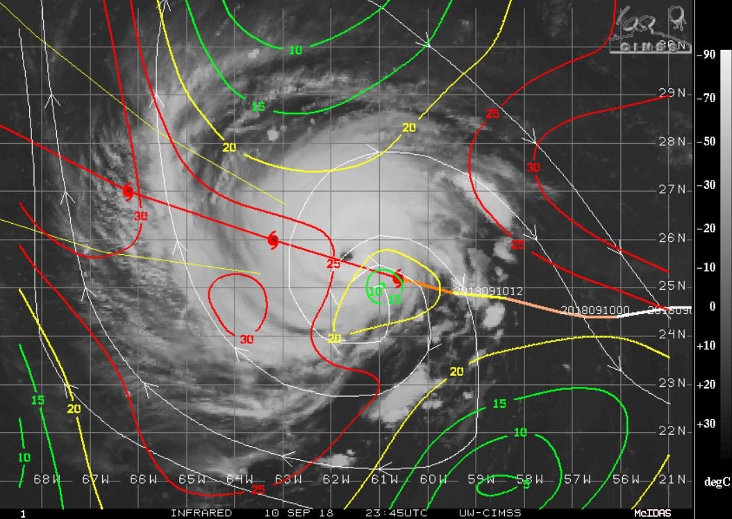
New advisory out. Cat 3 now. 125mph winds and 948mb. Seems like this has a mind of it's own. It strengthened rapidly a day early. Nhc keeps forecasting an increase but it held steady and now weakened. Regardless storm surge and flooding will be extreme with this
-
The eye in Florence has been strange all day. Very lope sided at times and chunky looking. For a cat 4, it's internal structure has been really disorganized. Curious if we will see it intensify more or more so hold where it is now
-
They also said the intensity assigned at this outlook may have been conservative. So I'm guessing they derived it from satellite estimates. I thought they used hurricane hunters at least for the major updates at 5am, 11am, 5pm, 11pm? When are they supposed to fly in Florence again?
-
Even though the ewrc is done now, the eye is so asymmetrical. Not sure if that effects future intensification or not
-
12 minutes ago, Drz1111 said:
Has it though? People say that with every storm. EWRC’s often take more than 24hrs.
I don't follow hurricanes as much as other severe weather so I wasn't aware of their average time to complete. I was thinking it was around 12hrs but with a larger eye trying to evolve I could see why it would take longer with complicated inner core dynamics
-
Yea this EWRC has really taken a while. Definitely could impact the strengthening expected. I'm thinking we see winds down this morning. Eye is going to be huge once it finishes so like David said, may take some time for winds to respond once pressures begin dropping again
-
What models are showing a stall? Is it just global models? Seems like most hurricane models bring it onshore
-
1 minute ago, 40/70 Benchmark said:
I think a best case scenario for the coast would have been a later ERC, but tough to tell for sure...could very well be another.
The ambient environment when the ERC begins is often a good indicator of how well it will recover, thereafter, so it will likely shrug it off tomorrow.
Convection already exploding around the center again. Starting to look more robust again. Not sure if ewrc finished but looks improved on satellite
-
Excellent write up David. Florence has at least another 24-36hrs in a very favorable environment before it gets closer to land and stronger shear. So def could see it ramp up again. I think our next advisory will have either a weaker storm or holding where it is. I'm betting on slightly weaker
-
 1
1
-
-
1 minute ago, csnavywx said:
The tendency is restrengthening after the completion of an EWRC, especially since it will be in ideal conditions over the next 48 hours.
Yea ample warm water and low shear. Just depends on how long this takes and if any dry air disrupts the inner core as it reorganizes
-
Million dollar question is will it resume RI after completing this EWRC or will this ever prevent it from hitting its max and keep it around the strength it is now or slightly weaker?
-
1 minute ago, SN_Lover said:
Florence does not look good on WV or IR. Going into a area of very strong shear and dry air...
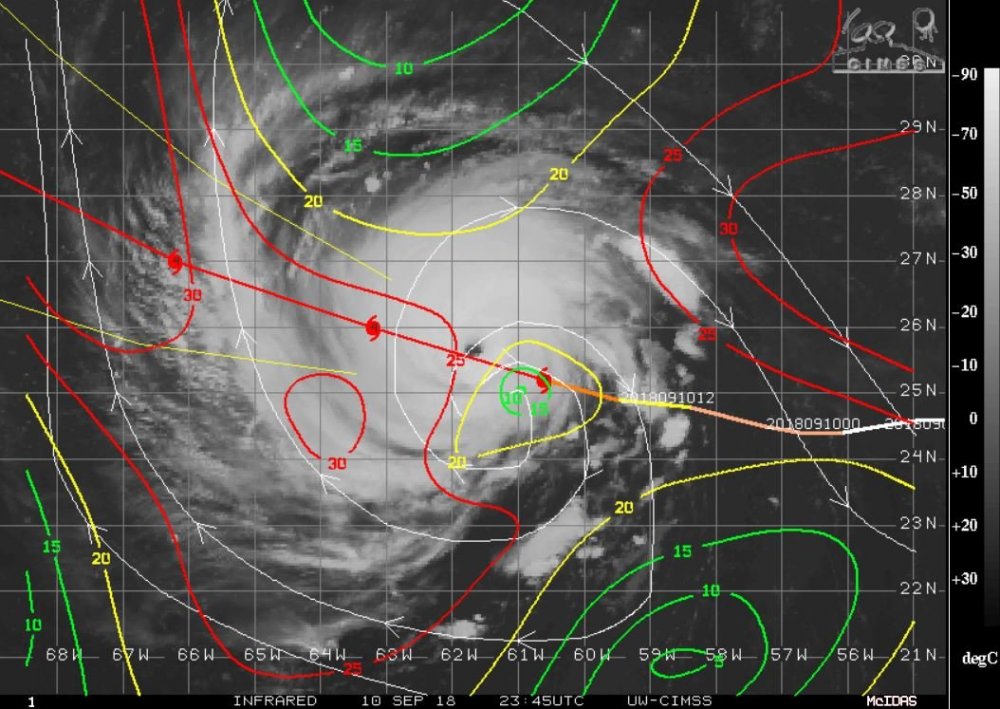

Yea I noticed that. Was that even forecasted? A lot of convection has collapsed on the edges and the eye has a chunky look
-
Now that they upgraded it watch it undergo an ewrc and weaken. Lol. Should have been upgraded hours ago. Def think we hit peak though
-
TWC just posted it
-
1
-
-
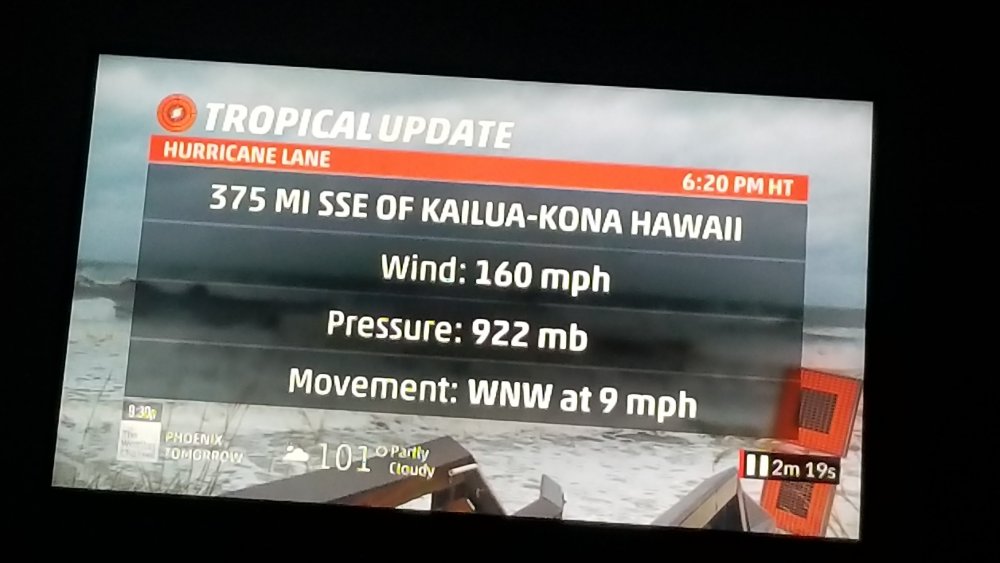
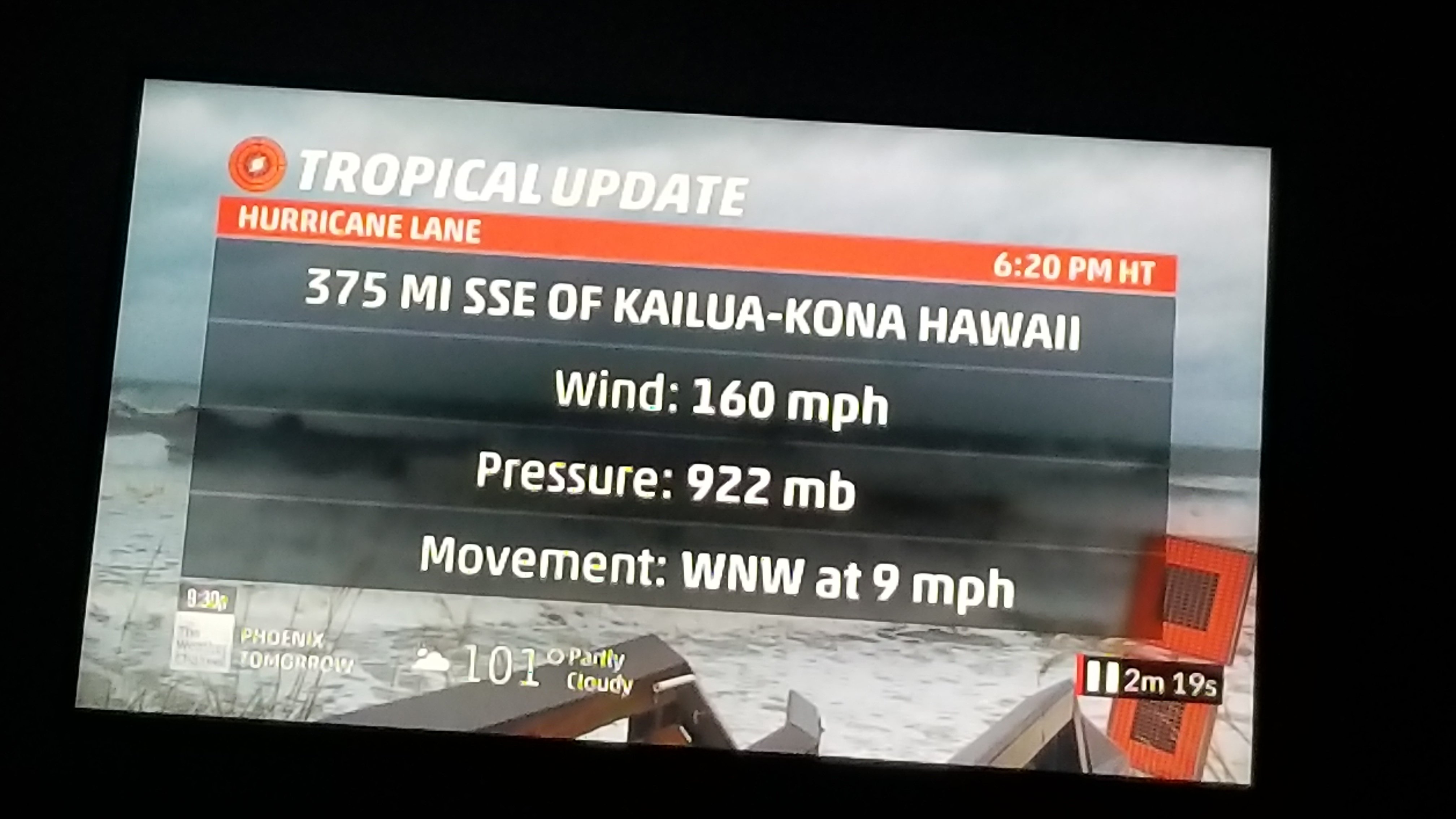
Just went cat 5! 160mph winds and 922mb pressure
-
2
-
-
3 hours ago, jojo762 said:
18Z NAM shows what is quite possibly one of the better looking setups of the year, especially for late June in Kansas/south of I70. Hard to get too excited given the awful trend we’ve experienced this year though, as was discussed above.
Storm mode is my main concern. Looks like things could grow upscale fast with strong forcing and high instability. I haven't looked to see how strong the capping is
-
Very well said. Pretty abnormal to see upper levels winds like that this south in late June. The instability/shear combo is impressive esp in southern KS on Sun. But the strong forcing makes me think you could see a lot of storms fire and get messy quick. But man if anything can stay discrete it will be tornadofest. OFB Sat in OK could get interesting
-
2 hours ago, CheeselandSkies said:
Either no one wants to jinx it or no one cares since it's after the summer solstice and everyone's chasecation is over. GFS has actually been pretty consistent with late next week wanting to get frisky over the Midwest.
Right. I'm shocked. I can't chase but still like discussing the threat
-
This thread is anomalously quiet for the weekend severe potential
-
Just now, andyhb said:
Because the current run is the one that is running right now, not the displayed one necessarily. Because Wednesday is not in range yet, it defaults to the previous run when you try to display the data for that particular day.
I just figured it out. My apologies. Was kinda confusing at first. I'm new to the site. But it has a bar up top showing the progress and shows the run at the bottom. I swear I'm not an idiot. Just had a blonde moment. Lol
-
1
-

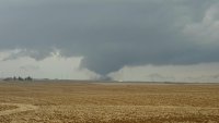
Major Hurricane Florence: STORM MODE THREAD
in Tropical Headquarters
Posted
Core isn't as exposed as it was earlier. Deeper convection blowing up around center and to the south. Might see it level off. But the intensity with this has been anything but predictable so who knows