

Radtechwxman
-
Posts
2,327 -
Joined
-
Last visited
Content Type
Profiles
Blogs
Forums
American Weather
Media Demo
Store
Gallery
Posts posted by Radtechwxman
-
-
Just now, cyclone77 said:
1st-world problems lol.

Right?! Meanwhile I'm like inches of cold rain with minimal ice and snow. Joy
-
 1
1
-
-
So close. Ugh. Need the slightest se shift. Probably going to end up seeing mostly rain here. What a waste of a dynamic system
-
0z euro very amped. Has heaviest snow axis pretty much out of IL
-
Good ol medium range model chaos. Lol. Probably going to see a lot of wild swings till we get sampling Thurs
-
4 minutes ago, mimillman said:
I would say boundary level temps are far too marginal for any significant icing anywhere near the metro, and precip rates are too high. Seems like 32-34 and rain followed by a few inches of slush. That’s verbatim of course, things can change.
Literally was just discussing this with a buddy. Temps very marginal for a good icing event and ground is pretty mild to start. Snow will likely be slop fest to with low ratios. We need some good quality cold air
-
2 minutes ago, Thundersnow12 said:
1” of ice and 6” of snow for SW/western Chi metro on the GFS
Yea GFS is all about the ice. Curious how much of that is sleet vs freezing rain. Definitely a northern shift in wintry precip on gfs today
-
I wish the Canadian could be right. Lol. Looks like 1-2in here. In the words of Ariana Grande "thank you next"
-
 1
1
-
-
Curious if we will see any last second shifts with sampling finally occurring tonight and tomorrow
-
 1
1
-
-
This thread died as fast as it started. Lol
-
2 minutes ago, Chicago Storm said:
It came north, with more of a slight SW-NE swath/track.
It can only go so far north though, with the PV lobe swinging into the northern lakes from Canada.
.Seemed like the snow swath was further south. But maybe just a narrower band and sharper north cutoff. Starting to feel it will be lucky if this snow even makes it to I74. Sometimes these frontogenic bands can really be thread the needle. Deformation band looks to clip here possibly
-
17 minutes ago, Chicago Storm said:
Huge changes again aloft.
Now it’s trying to close off the main wave as it ejects out. That’s a new one...don’t think we’ve seen a model/run trying to do that, until now.
.Wouldn't that lead to a further north scenario typically? Seems like it ended up more south. But it also has that high pressure really nudging south
-
12z nam coming in south. Pretty much stopping snow band at I72. At least for the WAA snow
-
3 minutes ago, Thundersnow12 said:
18z NAM looks pretty darn good if you take away it's usual low level dry air issues. Have a hard time believing that with weak NW sfc flow much of Sunday and when it turns easterly it's still weak. Not one of those true NE fetches of dry air.
Yea 18z nam looks good for a good portion of this forum. Nice WAA band. Curious to see if 18z gfs nudges north. 3km nam and 12km nam both looked nice
-
 1
1
-
-
1 minute ago, bhamwx205 said:
Why do you say its way too light ?
.He's saying it is underdoing the cold sector precip. Based on how it evolved it should be throwing more qpf into the cold side
-
2
-
1
-
-
Gfs more north compared to last night's run but definitely further south than it's been the last several days. Nam a bit further north than gfs
-
Comical. Gfs trended toward how euro had been and now euro trended a step toward how gfs had been

-
1
-
2
-
-
I'm sure the 1st of many model shifts we will see. I think gfs is probably too north and bullish and euro is too south and stingy. Not surprising to see gfs cave somewhat. Still not as bad as euro but definitely a step in the wrong direction
-
ILX seems to be concerned of drier air mixing out ice nuclei causing a possible drizzle situation over snow. But I'm not really seeing this in models
-
UPDATE...
Issued at 811 PM CDT Wed Oct 30 2019

No major changes to going forecast for the overnight hours, though
some concerns persist. Showers have developed west of the Illinois
River Valley this evening and will continue to spread east. Precip
has already transitioned over to snow from Galesburg through Macomb
and should see areas west of the Illinois River Valley transition
over by around midnight. Trends will have to be monitored overnight
with respect to the depth of the saturated layer. Main concern is
that several models indicate a narrow mid level dry slot will punch
across the Illinois River Valley overnight, resulting in loss of ice
nuclei at times, particularly between 06-12Z tonight. This would
transition precip back to liquid drizzle and cut down on snow
amounts. As is typical with mixed precip scenarios, it`s the
difference of only a degree or two which doesn`t lend much in the
way of confidence to make large scale changes to the forecast at
this time. Regardless of how precip pans out overnight, still
appears the best snow production will occur from the predawn hours
through the morning Thursday.
-
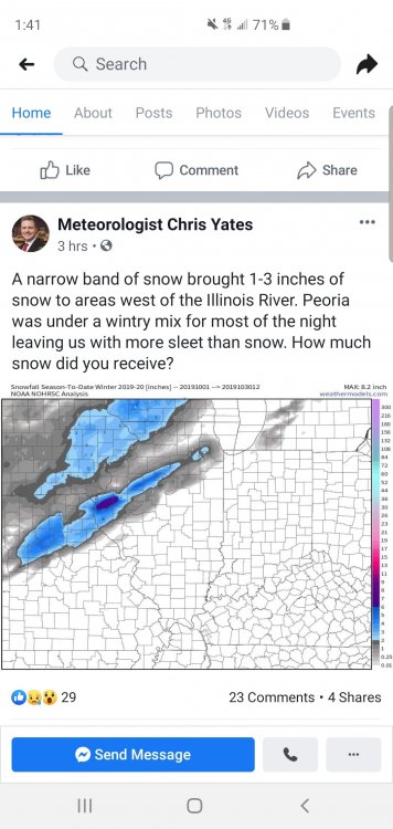
1 hour ago, Chicago Storm said:
That axis of snow last night and this morning from W IL into N IL ended up much more narrow than pretty much any model showed, even the NAM's, which usually do a fairly good job with banding. All guidance did a terrible job on amounts, and even QPF as well.
Based on reports, it looks like the main axis was ~15mile wide with 1-3.5", and a DAB surrounding that.
Couldn't have said it better myself. Definitely was modeled terribly. Our local met posted this
-
Rain snow line was more north than I anticipated. Good ol' 33-34 cold rain here with some sleet mixed in. Hoping I fair better with the main event. I'm honestly surprised temps didnt drop quicker with dews in upper 20s. Thought evaporative cooling would do the trick but I was wrong
-
3 hours ago, jojo762 said:
18Z NAM shows what is quite possibly one of the better looking setups of the year, especially for late June in Kansas/south of I70. Hard to get too excited given the awful trend we’ve experienced this year though, as was discussed above.
Storm mode is my main concern. Looks like things could grow upscale fast with strong forcing and high instability. I haven't looked to see how strong the capping is
-
Very well said. Pretty abnormal to see upper levels winds like that this south in late June. The instability/shear combo is impressive esp in southern KS on Sun. But the strong forcing makes me think you could see a lot of storms fire and get messy quick. But man if anything can stay discrete it will be tornadofest. OFB Sat in OK could get interesting
-
2 hours ago, CheeselandSkies said:
Either no one wants to jinx it or no one cares since it's after the summer solstice and everyone's chasecation is over. GFS has actually been pretty consistent with late next week wanting to get frisky over the Midwest.
Right. I'm shocked. I can't chase but still like discussing the threat

January 10th-12th Winter Storm Potential
in Lakes/Ohio Valley
Posted
If I remember right you're right by me. Lol. But yea typically flash flood watch + winter storm watch don't pan out well for winter weather. Best icing definitely to my northwest and same with snow. Meh. When gfs is your best outcome you know you're screwed