
Radtechwxman
-
Posts
2,105 -
Joined
-
Last visited
Content Type
Profiles
Blogs
Forums
American Weather
Media Demo
Store
Gallery
Posts posted by Radtechwxman
-
-
39 minutes ago, Maneee said:
Yeah-- you guys got over .5 an inch of precip. One would certainly wonder about how much of that will freeze.
Yea that's my thought. As we get closer to freezing it won't accumulate as quickly. But when I see dews hold in the upper 20s that makes me think temps won't climb too aggressively
-
0z nam would be something. Prolonged icing event here. I been thinking models are warming too fast given the arctic air mass in place and deep snow pack. Dews are low with temps in the teens. Evaporative cooling could offset major temperature increase. This could get interesting
-
21 minutes ago, ChiTownStorm11 said:
Getting absolutely crushed here in Champaign.
Yea they really got in a sweet spot north of rain snow line. Def could over perform. Getting some nice bands here now but all the really heavy stuff is more south and east. Wish this was crawling like the last storm. Ha
-
29 minutes ago, janetjanet998 said:
models of now current trends weaken the precipitation as precipitation blossoms south...its already breaking up some....but looks semi-convective,,
to our SW
1225 AM SNOW 2 SSE MACOMB 40.44N 90.67W
01/19/2019 M2.5 INCH MCDONOUGH IL TRAINED SPOTTER
STILL SNOWING.Not expecting much at all. These bands won't be here long and the stuff to the west is light. We will be lucky to see 2-3in. If that
-
2 hours ago, cyclone77 said:
Yeah I actually feel kind of guilty cashing in on this one. Our luck has certainly changed from that rough stretch from 11/12 to 13/14 when we went 3 winters in a row without a warning criteria snow. I feel for ya man! Here's hoping you guys cash in as we go forward. In regards to this storm I am very happy to see the central Ohio peeps finally cash in on a biggie.
Naw don't feel guilty. I'm happy for ya man. This never looked good here except when it was like a week out. It slowly went to crap for my area. Ha. Can't win them all. Just started snowing here. Winds picking up. Wonder if that dry slot in MO will impact me or if this band can keep sliding east from Iowa
-
37 minutes ago, cyclone77 said:
HRRR/RAP have shown 0.6-0.7" of precip from the QC through here the last few runs. If that works out that would be quite the change from most of the week when models continually showed this area in the drier area of precip. We'll see how it shakes out.
You always seem to luck out with every storm. Lol. QC area looks to get in on some intense repetitive banding
-
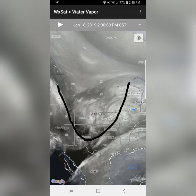
Looking at water vapor imagery appears the trough is fairly neutral right now. Maybe could end up more north? We shall see
-
 5
5
-
-
4 minutes ago, Central Illinois said:
ILX calling for wind gusts to 40mph now
Where did you see that? My grids still showing in the 30's
-
Well you all enjoy your winter storm, if it can even be called that outside the fgen band. Lol. Every single model has me in a doughnut hole of lower totals. I'm either in for a big surprise or very little snow. Hoping this thing trends stronger and more north but I have very little confidence in that
-
 1
1
-
-
5 minutes ago, cyclone77 said:
New Euro looks pretty good for the Cedar Rapids/Dubuque crew. 0.5" precip for those areas, which should fluff up to 6-7". 0.35-0.40" for the QCA/here, which would fluff up to 4-5". Gonna ride my call of 3-5" for here/QC. 6-7" for the CR crew.
You're lucky. You should see a decent event. Every single model has me in the snow void between the two more intense bands. I'm thinking 2-4in more so for Peoria now
-
 1
1
-
-
3 minutes ago, mimillman said:
WHoever gets in on the FGEN band will have a good time. If it happens to overlap with the lake effect, then will be an ever better time.
That's pretty much the legacy of this storm for us Midwest folks
-
Only good thing about models looking a mess is if it does trend up as it approaches it will feel like we're winning the lottery. Ha
-
2
-
-
2 minutes ago, hlcater said:
Pretty significant crapout on the 00z runs -- and these were the ones to be fully sampled. If the 00z GFS/HRRR/RAP are to be believed, there's gonna be a lot of busted WSWs.
My exact thoughts. Very strange system. We are either in for a big surprise or the biggest bust ever
-
Weird because it shows decent banding here but totals are paltry. Wonder if models have ratios too low. I honestly am at a loss for words
-
5 minutes ago, Hoosier said:
The backside jet streak is actually just coming into the west coast. I wonder if that will be enough to make a difference on 12z cycle. Not sure. Just wondering out loud.
We can only pray. End this madness. Lol
-
 1
1
-
-
Forecasting nightmare. Except for you guys in that fgen band. It's strange though how higher totals are lining up with stronger banding signals on hi res models
-
Well this was unexpected. Lol. What a forecast nightmare. Sfc low track very noticeably south on 0z runs this far
-
1 minute ago, AppsRunner said:
You aren’t wrong, but even then most globals and other high res guidance has been putting a nice gradient down somewhere in west central Iowa. Even then I don’t feel great about widespread warning criteria snow. Something about this storm just doesn’t feel right to me.
Like bad feeling it will underperform or that models are underestimating its potential?
-
6 minutes ago, AppsRunner said:
HRRR/RAP/RGEM trends have been extremely unfavorable. Or I could just be sleep deprived after a week of regular work and tracking this in my spare time, but I don’t feel good about this at all
I was noticing that. If 0z hrrr is right a lot of locations are going to underperform
-
2 minutes ago, Chambana said:
Do you see the fgen band as far south as Champaign?
Fgen band is going to be way north. We are depending on deformation band snows. Nearly all models have this screw zone in between the deformation band and fgen band with lower totals. We shall see if that improves in time
-
3 minutes ago, Central Illinois said:
hopefully for your sake it isn't nearly as big
It def isn't a dry air issue because there is widespread snow. Def some kind of forcing. But usually just south or north of an intense band is where you would see any subsidence. That's a large swath of weaker totals
-
1 minute ago, Central Illinois said:
FWIW 18z NAM coming in with a similar screw hole across Northern ILX
I just saw that
 I'm not sure I still believe a screw hole to be that large with this but concerning it shows one similar to euro. Guess only time can tell
-
4 minutes ago, mimillman said:
Du calme
Am calm. Just making a statement. They almost always are last to issue. Meanwhile rap and hrrr continue to look quite amped with this
-
1
-
-
Never have understood why the ILX office is the last to issue any headlines. Even if things change you can downgrade your headline and make changes
-
1
-
January 21-24 Winter Storm Potential
in Lakes/Ohio Valley
Posted
Weird here cuz it shows returns over Peoria but it is barely misting. Not really much of a glaze on anything. Temps already up to 30. Only thing that makes me wonder is with dews holding in the mid 20s wonder if evaporative cooling will prevent rain and favor more mixed precip longer