

Radtechwxman
-
Posts
2,327 -
Joined
-
Last visited
Content Type
Profiles
Blogs
Forums
American Weather
Media Demo
Store
Gallery
Posts posted by Radtechwxman
-
-
Nam definitely a more thread the needle snow. Could be due to a tight area of strong frontogenesis. Those tend to have brutal cutoffs. Globals seem to have a wider band of heavier snow likely due to how the trough is being handled. Curious to see other 0z guidance
-
Looks like nam continues to cave to other models. Another step NW. It is a lot narrower with the snow and and has a very small corridor of significant snow with a medium sized area of 2-3in
-
This shall be an interesting few days of model battles. Lol. GFS certainly took a drastic shift. Nam attempted to but not as drastic and a much narrower band of snow. GFS was more spread the wealth. Lets see what King Euro shows
-
 1
1
-
-
31 minutes ago, michsnowfreak said:
I did not realize it was already Wednesday or Thursday


I mean yeah it can change but trends definitely not going in the right direction as of now
-
Another winter storm DOA. Is it tornado season yet? This has been the lamest winter for a good wrapped up winter storm
-
 2
2
-
-
12 minutes ago, Chicago Storm said:
So... Mon night-Tue morning is dead and gone. Tue night-Wed morning is trending towards DOA. Wed evening-Thur morning looks good for somewhere in the area. Thur is the final potential wave, but may or may not occur, depending on how the trough and ejection evolves.
Cluster**** as expected.
.Pretty much the story of winter 2019-2020. Seems like the trend this winter is to look good in the long range then slowly fall apart as we get closer. Hoping we can get at least one decent wave out of this
-
Man Rockford is in the sweet spot tonight in a training heavy band
-
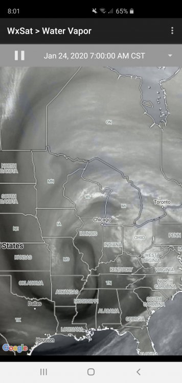
Well the last hurrah of this system sure went to crap. For such a pretty system on water vapor, it definitely isn't living up to how it looks. Lol. Lack of cold air ftw
-
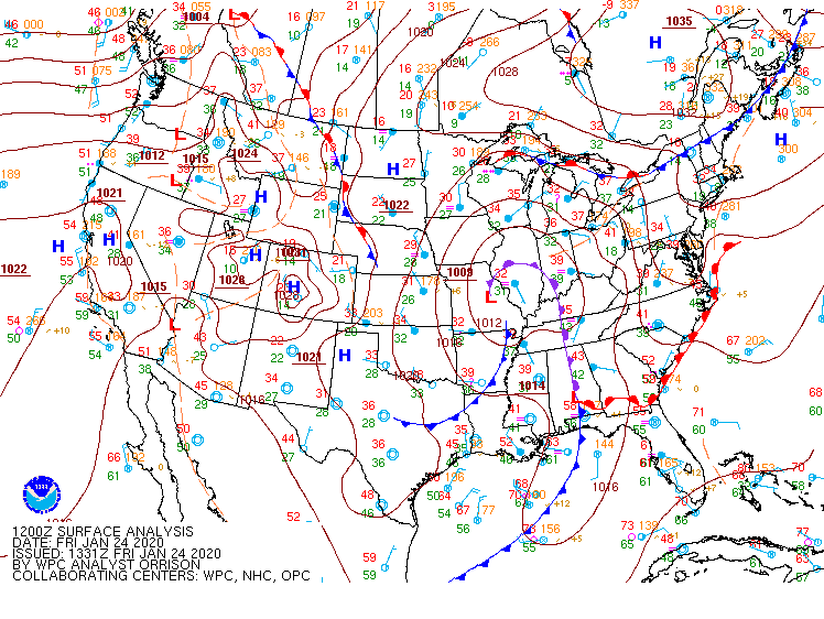
None of the models this morning are initializing well this morning with current low strength and placement. Most of them have a very broad 1012mb low over central IL and as of 1331z there's a 1009mb low just west of STL
-
 1
1
-
-
Ready to punt this sloppy mess of a storm. What happened to real winter storms? Seems like this last part is pushing more and more ne on model runs
-
Finally ripping snow here. Nice fat flakes. But doesn't look like this will last super long tonight
-
29 minutes ago, cyclone77 said:
Snow has been pretty light so far this eve. Picked up 0.2" since the snow began shortly after sunset.
Same thing here. Pretty uneventful so far. Feel like Fri night into Sat will be best here
-
10 minutes ago, Chicago Storm said:
You don't want that brighter band to move north...that's the R/S line.
Lincoln has been rain for a few hours now.
I'm just surprised snowflakes are so tiny. I think my marginal temp now isn't helping. Snow barely accumulating
-
Snow returns seem to be drying out in Peoria area. Seems like that band is struggling to lift north as well. Flakes are like pixie dust so far
-
7 minutes ago, Chicago Storm said:
This is proving to be an understatement.
Run-to-run catch-up is comical.
On temperatures? I'm thinking it's advancing the rain snow line west too quickly
-
6 minutes ago, janetjanet998 said:
I have no idea ....it will be a NOWCAST situation...but never underestimate dynamic/convective cooling
and a deformation zone later
if it stays all snow many people are going to be surprised
My thoughts exactly. And being near rain-snow line is a good sweet spot if you stay on snow side. Lol
-
40 minutes ago, janetjanet998 said:
Nice burst here now..big flakes under the heavier returns
going to be some "uneven" storm reports totals I think ....depending on how often one clears the snowboard to measure before it melts or compacts (every 6 hrs for some longer for others)
I know you're close to where I am. What do you think of hrrr bringing the rain snow line as west as the IL River? I think it could come close but sure as west as hrrr/rap show it
-
Just now, Hoosier said:
The GFS is still at it with the 925 mb temp thing. Here are the last few days of runs valid at 00z Friday. Notice the last few runs in severe catchup mode.

Utter trash model. Literally shows rain here from tomorrow afternoon through the rest of the event. Makes no sense. I do believe there will be rain at times but there will definitely be snow at night
-
1 minute ago, Hoosier said:
HRRR may be having some sfc temp issues as its known to do, especially in it's longer range.
Just nam is showing this current wave being more robust than it currently is so has me wondering if it is right on a more robust 2nd wave than other models
-
0z hrrr torchy like gfs. Has rain wrapping around low all night Fri. I just don't buy that. There should be some CAA wrapping on backside of low. This first wave is definitely looking pretty paltry on radar. Wondering if precip by Gulf is disrupting moisture feed. Also looked like that first disturbance lifted more west than anticipated
-
11 minutes ago, RCNYILWX said:
Agree that better dynamics could be at play later on in the event. Also it's late January and not late March or April, that helps. I was thinking about the daytime vs nighttime issue and even though it's not worry about sun angle season yet, would think with such marginal BL temps, daytime might hurt if rates are too low vs same conditions at night.
Sent from my SM-G965U using Tapatalk
Totally agree with this. With an already high water content snow with low ratios marginal daytime temps will definitely favor more slush over accumulations and white rain like you said. I think best shot here will be overnight Thurs into Fri when wind direction shifts more northerly as upper low pulls east
-
1
-
-
GFS continues to be a torch with most snow confined to Great Lakes. Either it's going to hit a home run being the only model sniffing out warmer temps or going to look really stupid next to the rest of guidance. I do believe there will be transitions between rain and snow especially preceding the main upper low closing off. However I think once that upper low deepens and closes off that things will certainly be more snowier than gfs is depicting
-
2
-
-
12 minutes ago, RCNYILWX said:
If anyone is looking closely at point and click or hourly weather graphs for this event we do have a fair amount of rain and snow mention during the day on Friday because of surface temps being as marginal as they are. Would think that at periods of lower precip rates that we could mix or flip to rain, or falling snow would not accumulate and essentially function as white rain.
Sent from my SM-G965U using Tapatalk
Definitely very marginal temps for any accumulation. However with a relatively strong closed low and the fact it will be strengthening as it passes over us, makes me think dynamics could compensate for lack of colder air. I remember this clipper a few years ago came through with very marginal temps but it was very compact and wound up. We ended up dynamically cooling to around 32-31 and efficiently accumulated snow with moderate to sometimes heavy rates. I know this isn't a clipper but made me think of how wrapped up this system is aloft
-
2
-
-
Pretty similar. Semi on board with nam with colder and snowier. Gfs has a lot more rain and snow slop. To me the pattern would support a more gfs like solution but we shall see

February 4th-7th Winter Storm Potential
in Lakes/Ohio Valley
Posted
Well this forum died as quick as it started. Lol