

cyclone77
-
Posts
18,237 -
Joined
-
Last visited
Content Type
Profiles
Blogs
Forums
American Weather
Media Demo
Store
Gallery
Everything posted by cyclone77
-

Devastating tornado strikes Joplin, Missouri
cyclone77 replied to Hoosier's topic in Weather Forecasting and Discussion
Don't think this vid has been posted yet. Kind of a different perspective from south of the tornado. The vid owner said he lives just south of Charlies Chicken, which I checked and is on E32nd street. The tornado missed him by several blocks to the north. At the beginning of the video it looks pretty benign, but after about the 1:40 mark you start to see power flashes to the west-northwest. By the end of the video there's multiple power flashes, and a faint roar can be heard to the distant west. You can also see the RFD core heading right at them. -
Devastating tornado strikes Joplin, Missouri
cyclone77 replied to Hoosier's topic in Weather Forecasting and Discussion
I take it you went to high school there? That has to be surreal to see that being torn down. -
Devastating tornado strikes Joplin, Missouri
cyclone77 replied to Hoosier's topic in Weather Forecasting and Discussion
Wow, that was crazy. You can see how the rain wrapping around the tornado blocked it from view. As soon as he punched through the wrapping rain curtains there was basically just a wall of black there inside the hook. -
Devastating tornado strikes Joplin, Missouri
cyclone77 replied to Hoosier's topic in Weather Forecasting and Discussion
My bad. The map I had ( http://www.weather.com/outlook/weather-news/news/articles/tornado-damage-swath-joplin_2011-05-24 )showed the track ending on the southeast side of Joplin. I didn't realize it continued on that far as I was only focusing on Joplin. Thanks for pointing out my error. -
Alaska/Western Canada obs and discussion
cyclone77 replied to patrick7032's topic in Central/Western States
Very nice pics man! Makes me really look forward to October down here. -
Devastating tornado strikes Joplin, Missouri
cyclone77 replied to Hoosier's topic in Weather Forecasting and Discussion
He's just north of the intersection of Indiana Ave and East 17th Street. He's basically at that intersection at the beginning of the vid, and then retreats to the house north of the one on the corner. -
Devastating tornado strikes Joplin, Missouri
cyclone77 replied to Hoosier's topic in Weather Forecasting and Discussion
With Google Earth I also scanned a bit southwest of where the NWS placed the formation of the tornado (at JJ HWY and Newton Road) and found several uprooted trees west of John Duffy Drive. They're all uprooted, and laying towards the northeast. This was probably either caused by a circulation passing just north of that location, or from the initial RFD that slammed down into that area just southwest of the forming vorticies. The Google Earth images are dated June 7, 2011, so this would explain why the foliage on the uprooted trees is brown. -
Devastating tornado strikes Joplin, Missouri
cyclone77 replied to Hoosier's topic in Weather Forecasting and Discussion
I'm pretty sure I found the location of the chase video that shows the formation of the tornado shot from the north. The chasers are driving south with the formation of the multiple vortex tornado to their due south. In the video around the 10 second mark you see them approach a railroad crossing. There's only one north/south road with a railroad crossing that would line up with the formation of the tornado, and that is on South Central City Road. This road actually turns into JJ HWY south of the tracks, and the NWS places the formation of the tornado at the intersection of JJ HWY and Newton Road. -
Devastating tornado strikes Joplin, Missouri
cyclone77 replied to Hoosier's topic in Weather Forecasting and Discussion
Those are some amazing images. The cell phone tower portion is very interesting. Looks like one of the strong multiple vorticies passed just north of the fallen tower. It had fallen to the northeast, while just a few hundred yards to the north the uprooted trees blew over towards the west. The E24 and Meadow Lane image looks like it was snapped earlier than the image I posted yesterday, as the uprooted tree in the cameraman's backyard hadn't been cut up yet. -
Devastating tornado strikes Joplin, Missouri
cyclone77 replied to Hoosier's topic in Weather Forecasting and Discussion
I found this location as well. This was filmed at the corner of West 30th Street and South Eiler Ave. These guys got very lucky, as just a few houses to the south were severely damaged and destroyed. It's amazing that the tornado was capable of that type of damage so quickly. -
Devastating tornado strikes Joplin, Missouri
cyclone77 replied to Hoosier's topic in Weather Forecasting and Discussion
It took me awhile, but I was finally able to locate where the video was shot. The unique dead end road with the two driveways at the north end helped quite a bit. The pine tree that was left also helped. These guys were pretty close to the end of the tornado, and probably would have been missed if it hadn't curved east-southeast before lifting. I'm still amazed at how quickly it went from destroying house after house to no damage at all. EDIT: I should also note that the map incorrectly continues 24th Street right through the cameraman's garage lol. 24th Street actually has a break in it there, and continues behind the cameraman's residence. EDIT #2: I forgot to mention another thing I noticed in the two videos. In the first video the cameraman pans to the right (northwest), and you notice a little white car parked in front of a house. In the aftermath video when he pans over in that direction you see the same white car in the same exact position, yet the house is GONE.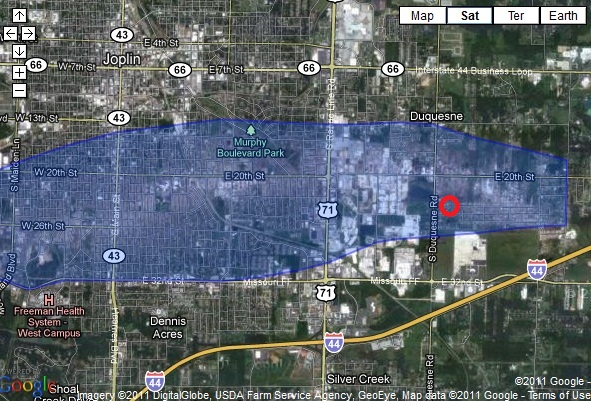
-
Devastating tornado strikes Joplin, Missouri
cyclone77 replied to Hoosier's topic in Weather Forecasting and Discussion
Wow, unfortunately it looks like they received quite a bit of damage there. In the aftermath video you can see the sun setting in the direction the camera was pointing at in the beginning of the first video. This tells us the winds were blowing from the south as the tornado approached, and more than likely means they were probably on the southern side of the swath. Judging by the fact the tornado was very loud for a few minutes before it arrived makes me believe this was shot after the tornado had achieved an enormous size. If I were to guess I'd estimate he was somewhere southeast of you just on the other side of the damage swath. I'm glad it appears that his family and the surrounding neighbors made it through okay. EDIT: Another thing I noticed in the first video was the surprising amount of CG activity very close to when the tornado arrives. I remember seeing a video from a chase group that was heading south through the city that also shows CGs hitting on the outer edges of the wrapping rain curtains that encircled the tornado. This is a near perfect example of what a strong HP supercell is capable of. I believe the Plainfield Illinois F5 was probably very similar in appearance, as it too was totally wrapped in rain. -
Devastating tornado strikes Joplin, Missouri
cyclone77 replied to Hoosier's topic in Weather Forecasting and Discussion
Here's sort of an interesting sequence of videos all shot by the same person. This is between 29th and 30th Street on South Brownwell Ave. He was a few blocks south of the main damage swath, but according to some of the damage maps I looked at he's considered to be on the southern edge of the damage swath. In the third video you see all kinds of small debris on his street, and can clearly hear the rain-rapped tornado roaring to his north. Most of the time he's filming towards the east.... -
Devastating tornado strikes Joplin, Missouri
cyclone77 replied to Hoosier's topic in Weather Forecasting and Discussion
The above two vids were actually shot by the same person. Apparently his house suffered some damage as well, as he shot this aftermath video. Looks like his neighbors just up the road had considerable more damage. -
Devastating tornado strikes Joplin, Missouri
cyclone77 replied to Hoosier's topic in Weather Forecasting and Discussion
Some amazing videos right there. In the top vid it looks like he's shooting west, as the tornado begins to take shape just to his southwest towards the end. He was probably narrowly missed just to the south. That last video is absolutely astonishing to me. I can't believe how long they waited to go inside the house. That roar was downright terrifying, and that's just me sitting behind the computer monitor. Can't imagine what that would have been like in person. I'm guessing they must have been on the southern edge of the tornado, as it appears they sustained more of a moderate brand of damage based on what I can tell towards the end of the vid. Also, it appears you can see the left (southern) edge of the tornado right before they head indoors. The sky is noticeably brighter behind the trees to the left. -
Devastating tornado strikes Joplin, Missouri
cyclone77 replied to Hoosier's topic in Weather Forecasting and Discussion
Thanks for all the pictures. It's amazing how quickly some of the trees sprung back to life. Even though the landscape still looks barren, it seems a lot more upbeat with most of the debris removed. It's starting to look more like a giant construction site now than a scene of a huge disaster. They've made amazing progress down there. -
Devastating tornado strikes Joplin, Missouri
cyclone77 replied to Hoosier's topic in Weather Forecasting and Discussion
I'm still thinking the supercell that was in the process of merging with the Jopin supercell from the south helped enhance the meso of the Joplin supercell. -
Devastating tornado strikes Joplin, Missouri
cyclone77 replied to Hoosier's topic in Weather Forecasting and Discussion
Don't know if this video was posted or not. This must have been on the northern edge of the tornado, as it says the camera's pointing north. -
Devastating tornado strikes Joplin, Missouri
cyclone77 replied to Hoosier's topic in Weather Forecasting and Discussion
The amount of force it would take to destroy a well built brick building like that is just unfathomable. -
Devastating tornado strikes Joplin, Missouri
cyclone77 replied to Hoosier's topic in Weather Forecasting and Discussion
Horrible news there. I'm sure there will be many case studies done on this tornado. This has been an especially active year for violent tornadoes, but this tornado is the most unusual in how quickly it evolved, and how violent it was. -
Devastating tornado strikes Joplin, Missouri
cyclone77 replied to Hoosier's topic in Weather Forecasting and Discussion
Just watched the radar loop of the Joplin storm and noticed something kind of interesting. As the parent supercell was moving through Joplin another supercell had quickly developed just to the south. This supercell quickly moved northeast and seemed to interact with the Joplin sup. The FFD on the northern edge of the southern sup may have helped to tighten up the RFD on the Joplin sup, and may have also helped tighten/funnel the inflow on the east/southeast side of the meso. That could explain why the thing exploded in intensity so quickly, and also why it only lasted 6-7 miles. http://www.rap.ucar....e=23&duration=2 NOTE: The above radar loop will not be viewable after today, as it will fall off the 5-day archive. -
Devastating tornado strikes Joplin, Missouri
cyclone77 replied to Hoosier's topic in Weather Forecasting and Discussion
Glad you're okay JoMo! -
Devastating tornado strikes Joplin, Missouri
cyclone77 replied to Hoosier's topic in Weather Forecasting and Discussion
Keep in mind even if JoMo is okay (and I sure hope he is), unfortunately there's a very good chance he may have family and friends who may not have been so lucky. -
Historic Tornado Outbreak April 27, 2011
cyclone77 replied to CUmet's topic in Weather Forecasting and Discussion
The last one they have listed is from 0300. There's surely been more since then. -
Historic Tornado Outbreak April 27, 2011
cyclone77 replied to CUmet's topic in Weather Forecasting and Discussion
I meant about to cross into North Carolina, not Virginia.