

LVblizzard
-
Posts
3,804 -
Joined
-
Last visited
Content Type
Profiles
Blogs
Forums
American Weather
Media Demo
Store
Gallery
Posts posted by LVblizzard
-
-
6 minutes ago, LVLion77 said:
This one is not our storm. We will be lucky to hit 2”. Our friends to the south are hitting the jackpot.
.I think we’re good for another inch or so later as the precip fills back in. But yeah it would have been really nice to be in those heavy bands.
-
 1
1
-
-
Steady light to moderate snow in Allentown. About an inch so far.
-
9 minutes ago, RedSky said:
Weak sauce 0z NAM hope it's a trash run
Huh? Snow map is very similar to 18z. 3km run cut totals very slightly but just minor changes.
-
1
-
-
Expecting 2-4" in my Allentown suburb. Leaning closer to 2" than 4". Should still make for a pretty scene tomorrow.
-
1
-
-
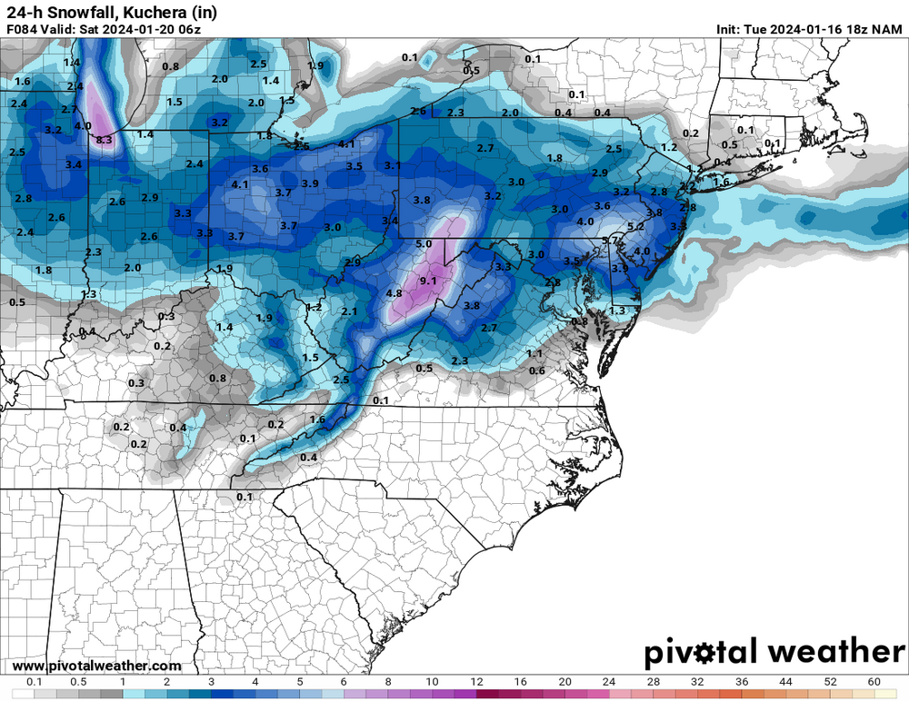
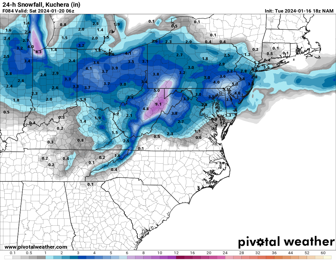
I just don’t understand where these aggressive numbers from Mt. Holly are coming from. There is virtually no model support for widespread 4-6.” Aside from maybe the HREF.
-
1
-
 1
1
-
-
HRRR keeps bringing the Norlun trough south. Not liking the trends - not just with the HRRR but all the models.
-
2
-
-
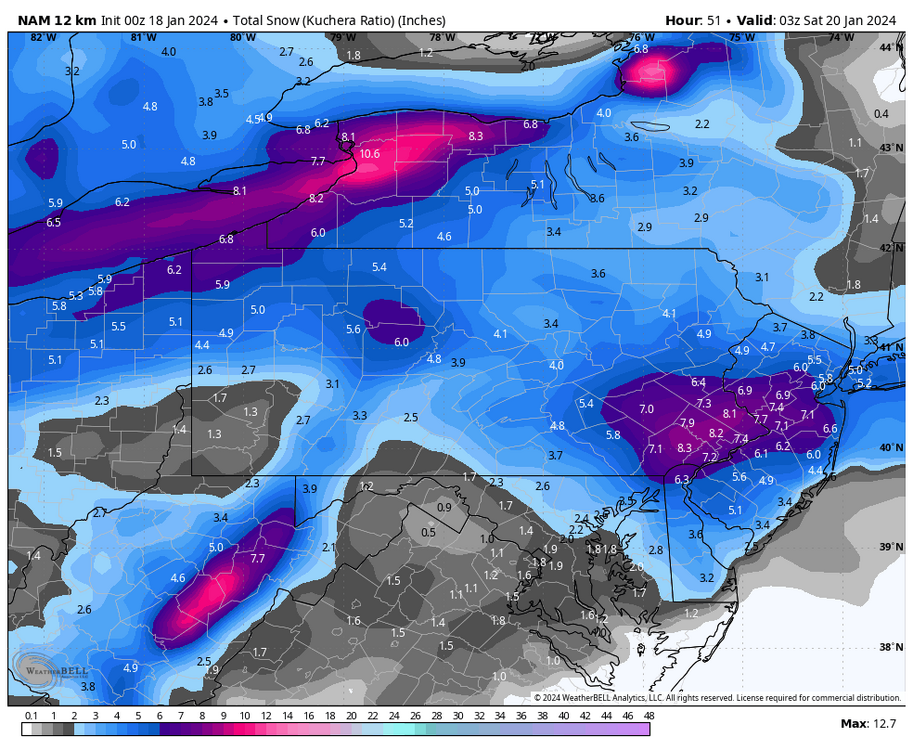
11 minutes ago, The Iceman said:
Not much change from Mt. Holly's snow map after the 12z runs:
I think 2-5" is a good bet for much of the subforum. There will be a narrow corridor of 4-8" wherever the IVT sets up.
Looks good south of 422 and the turnpike but I’d cut everything by 1-2” north of that.
-
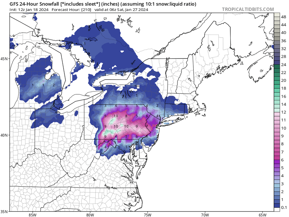
Anyone see the 12z GFS for next Friday?
-
1
-
1
-
-
Just updated my page, I stuck with 2-4” for the Lehigh Valley. Not sure where all these ultra aggressive forecasts are coming from. I’d be more surprised if my forecast busted high rather than low.
-
9 minutes ago, anthonyweather said:
DT and fox 29 latest


.Is DT on crack or something? That is just a ridiculous map.
-
1
-
-
NAM and the other American hi-res models vs. everything else. Quite the battle we have here. Hopefully we get some clearer answers by tomorrow's 12z suite.
-
2
-
-
We have officially been NAM’d. 0z run slams us with the inverted trough.
-
3
-
1
-
-
8 minutes ago, anthonyweather said:
It’s a Friday morning start. Not Thursday night
.Overnight Thursday means late late night. Like 3-4 am. Just accounting for that possibility. I do think 6-8 am is most likely.
-
1
-
-
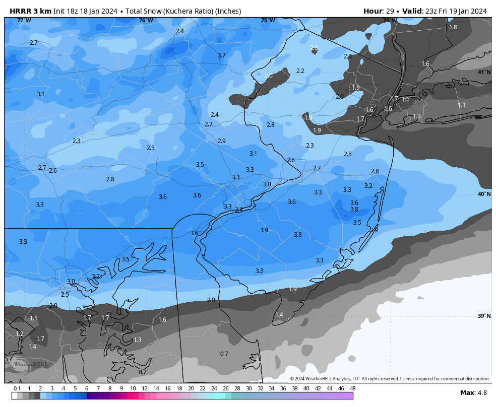
18z HRRR is certainly interesting. Won’t let me add the image for some reason but take a look for yourself.
-
 1
1
-
-
0z NAM/RGEM both with another 3-6” region-wide on Friday. Chances of a blockbuster are decreasing but this still looks like another nice event.
-
1
-
-
38 minutes ago, RedSky said:
GFS manages to make a winter storm during the relax period next week I give it Xtra credit
I’ll be in Colorado so it’ll probably happen. At least I’m guaranteed to see snow on the ski slopes.
-
18z NAM is a decent hit for Friday. Much better than 12z.
-
3
-
-
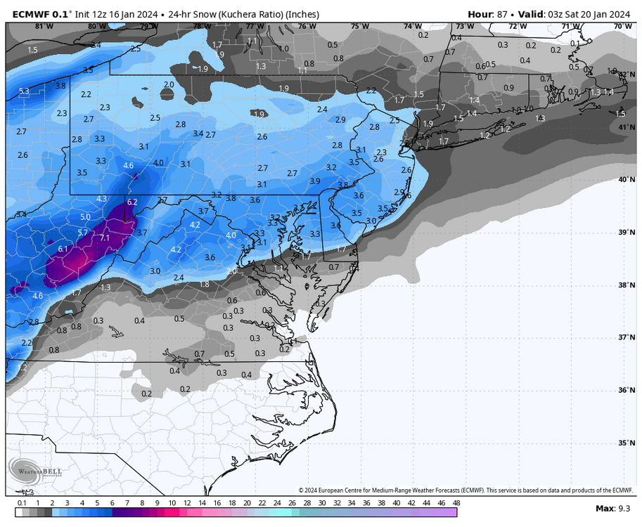
Euro gives us some halfway decent snow on Friday now. We’re one small trend away from something more significant.
-
2
-
-
1 minute ago, anthonyweather said:
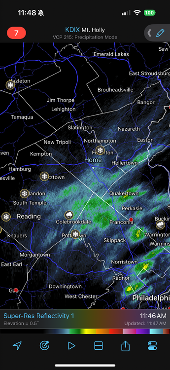
Ripping in Bethlehem. 1”+ hr
.Ditto in Lower Macungie. Heaviest snow of the storm. That low must really be getting cranking.
-
1
-
-
That Lehigh Valley band is really nice. We’re up to moderate snow now. Looks like we’ll be in this for at least another 30 minutes.
-
Still a steady light snow out there. We briefly mixed with sleet but we’re all snow again. Hoping this little band keeps expanding and drops another inch or so.
-
1 minute ago, Mikeymac5306 said:
GFS still has it too far OTS for my blood.
NAVGEM looks to be fairly aggressive with it, and a solid SECS.
The GFS had today’s storm completely OTS and not even close 3 days out. It always seems to get completely lost in the days leading up to a storm, then joins the party way too late.
-
1
-
-
6z and 12z models generally trending better for a moderate event on Friday. The potential for something big is still there but the consensus seems to be a near miss.
-
1
-
-
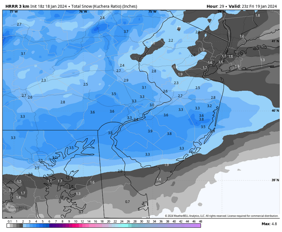
Still snowing lightly here in Allentown. Looks like about 3” here. Hopefully we get some backbuilding going on as we’re just barely missing that precip in the Philly burbs right now.


January 19, 2024 Powder Snow Event
in Philadelphia Region
Posted
Still steady light snow in Allentown. We’ve missed all the heavy bands unfortunately. We might get to 2”. Slightly disappointing even though my expectations were not very high. No clue what Mt. Holly was thinking…and their point forecast still says 3-5” for some reason.