

Isotherm
-
Posts
7,930 -
Joined
-
Last visited
Content Type
Profiles
Blogs
Forums
American Weather
Media Demo
Store
Gallery
Posts posted by Isotherm
-
-
81F dew point 55 here, after a morning low of 50. Warm in the sun but still quite comfortable.
-
 1
1
-
-
2 hours ago, doncat said:
77 high today...Should radiate nicely tonight.
42.5F to 77.5F and now down to 58F already. Impressive diurnal ranges the next few days.
-
1
-
-
1 hour ago, frd said:
The El Nino theme continues
I am not sure precisely what is included in this index; however, while it may be a fine proxy for ENSO specifically, I do not believe it adequately considers other pertinent variables, such as the GWO and associated torque variations, which would provide a more veracious macroscale view in my opinion. At several points on that graph in which neutral or Nino is depicted, other indicators such as GWO cycling and tropical forcing ostensibly indicated a Nina esque atmospheric regime. Again, it may be fine for the purposes which it is designed for, but I personally would not rely upon it as the most accurate indicator of the macroscale atmospheric status.
-
1
-
-
33 minutes ago, WEATHER53 said:
KA has retired from the long range forecasts. Other than Matt Ross nobody had a lengthy track record like that, approaching 70% and to my record keeping since 1980 there were just 4 times where he missed on both snowfall and temps with 22 double hits and just the four mentioned double misses.
i will be still doing mine and I’m about 62/63% but not as good as he or Matt.
KA was one of the few in the already small long range community who produced consistent results. I did not initiate my long range forecasting career as early as you, KA, or Matt. However, I began in 2006, and have a 80.0% success rate [including summer/winter outlooks, 25 outlooks total sample size]. As per usual, I intend to issue a winter outlook again this autumn. Will look forward to reading yours.
-
5
-
-
13 minutes ago, psv88 said:
Good forecast Tom. Looking forward to your winter outlook.
Thanks, Paul.
I'm envisioning another interesting outlook season -- think there will be a bit more divergence in forecasts this year.
-
1
-
 1
1
-
-
21 minutes ago, SACRUS said:
Down to 54 last night, another great weekend continuing the theme.
Next shot at 90 for the warmer (southern spots) Wed but gotta watch 'clouds getting in the way' then more ridging into the mid and sexond half of Sep. Although it could be dirty ridgng with potential of tropical influences so while ridging and upper pattern signal very warm finish it may be way of warmer lows. I think the following is possible
90 degree days from here on out
NYC: 1 (maybe 2)
EWR/ LGA: 2-3
PHL: 3- 5I concur, @SACRUS. Wednesday will likely be a near miss; Thursday has a good chance as does Mon-Tues.
-
5 hours ago, nzucker said:
I mean overall your forecast was a hit, but the idea of heat returning in the 2nd half of August never really came to pass.
July was an extremely hot month, nearly up there with '55 and '66.
Also, you went a little heavy on 90-degree days; part may be attributable to the vegetation in Central Park.
Yes, no disagreement there. The second half of August tended cooler and 90F days were too high in the PHL-NYC corridor as noted in the verification above. There may actually be 1 to 3 more chances for 90F for many of these stations but we'll see on that.
-
 1
1
-
-
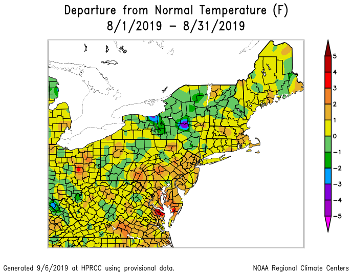
This is a warmer than average August for most of the Northeast and Mid-Atlantic. Slightly warmer than normal (but remember, the forecast for August was not very hot either).
-
2 hours ago, nzucker said:
We didn't really have "increasing heat and humidity" in August. I think the month finished +0.3F with 3 days that hit exactly 90F. That's not exactly a warm August.
Dew points were quite high most of August through the third week. It was very humid, and most in the Northeast corridor were slightly warmer than normal. While August was slightly cooler departure wise than expected, July compensated. The trimonthly range is most important for long range seasonals (which directly hit). I often debate whether I should even include monthlies, because it's substantially higher difficulty than the already difficult seasonal, and people will tend to myopically focus on any comparatively diminutive error in one of the monthlies.
And the "increasing heat and humidity" was taken a bit out of context. July and August certainly featured increased heat and humidity compared to June, with respect to normal. The assertion in the outlook was that the first 1/3 of summer would be coolest relative to normal with increasing warmth/humidity thereafter, which verified objectively.
-
1
-
-
Summer outlook verification can be found here. The summer went very well in accordance with expectations.
-
1
-
-
http://www.lightinthestorm.com/archives/1195
VERIFICATION
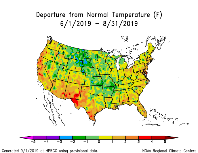
Temperature Departure Forecast JJA: +1 to +2
NYC/NJ Local Station Departures:
NYC: +1.2LGA: +2EWR: +1.3JFK: +1.2BDR: +1.9ISP: +2.1Mean of all stations: +1.6This fell directly within the target range. The notion that June would be near normal with increasing heat and humidity in July and August was correct, as well as the forecast for at least one major heat spell.Precipitation Forecast for JJA was wetter than normal. Results:NYC: +0.49″EWR: +2.1″LGA: +0.53″JFK: +0.75″BDR: +0.92″ISP: -0.35″Mean of all stations = +0.74″ wetter than normalThis was a wet and active T-storm season overall, as anticipated in the Northeast and Mid-Atlantic.90 degree day projections / actual:90 Degree Day Projections / actual through 9/2/2019:
BOS: 14 / 14 error: 0
NYC: 26 / 14 error: +12
LGA: 30 / 23 error: +7
EWR: 33 / 24 error: +9
PHL: 36 / 31 error: +5
DCA: 45 / 52 error: -7
RDU: 52 / 61 error: -9Total error: +17 [overall, slightly warmer than anticipated]This was a very good forecast considering the high level of difficulty; the numbers were virtually on target for the Mid-Atlantic and New England. It was slightly too many for the PHL-NYC corridor.Summer Outlook 2019 Grade:This will be considered a hit. The forecast was “A” locally. Including the nation-wide picture, the expectation for a very hot West Coast and Mid-atlantic/SE US was correct, and warmer than normal most other locations. The primary flaw was slightly cooler anomalies in the N/C Plains. The nationwide grade is therefore a B+.The overall final grade is A-

-
1
-
-
4 minutes ago, LibertyBell said:
thats not a climate lol, thats a microclimate ;-)
It's actually a different climate zone [that is, my area of CNJ versus LGA] if you utilize any climate classification system as an arbiter. As per the Trewartha climate system, I am in "Dc - Continental" and LGA is "Oceanic." And if you employ the Koppen system, my area is "Continental-Hot summer" whereas LGA is "Sub-tropical" [using the 0C isotherm coldest month system].
-
2
-
-
8 hours ago, doncat said:
LGA had 58, 70+ degree mins...lol.
Different climate there. Looking at my records, I have 16 70F+ minima [actually impressively high for here, due to high dews]. Departure was slightly under +1, and 15 90F days.
-
Most will finish JJA with temperature departures of +1 to +2, via a normal June, very hot July, and slightly warmer than normal August. However, for posterity, those departures will not impart the entire story of this summer -- that is -- very tropical-esque humidity from approximately June 25th through early August, then again for a week in the latter part of August. We saw protracted high dew points this summer, and spasmodically coupled with high ambient temperatures [see, July], yielding exceptionally elevated heat indices. Hence, this summer will be remembered as another very humid one, warmer than normal, but not very hot in the multi-month sense [though 1 month was very hot].
-
1
-
-
15 90F days here, after 4 this week. The period 9/3-9/9 could get quite warm again, with potentially a few more 90F chances.
-
1
-
 1
1
-
1
-
-
For what it's worth - The Old Farmer's Almanac appears to be forecasting another non-winter in the Northeast for the second consecutive year.

-
3
-
-
92.2F / 78F, HI 107F right now. Day 13 of 90F. Torching here.
-
2
-
-
15 minutes ago, doncat said:
88/77 currently ….Hit 89 earlier.
89.8F/77F, HI 102F here now. So up to 12 90F days on the season. Very hot/humid day.
-
46 minutes ago, SnoSki14 said:
I do think all that warm water around Greenland will allow for more blocking than we've seen.
Looks like a +PDO as well. Pacific firehouse could still be a problem though strong blocking periods could offset that somewhat.
The water near / immediately south of Greenland is only about 10-13 degrees Celsius, so it's neither objectively warm, nor is it sufficiently warm to possess the available energy to act as a forcing agent in and of itself. It's possible that it can act as a feedback agent, but if other atmospheric drivers supersede, they will mediate circulation structure unpropitious for blocking. The notion that water of a rather diminutive temperature can act as a controlling modulator of the pattern is tenuous in my view. Again, it's a factor, but on the list of what I would examine, tertiary. Edit: also note that the warmer than normal water south of Greenland was almost entirely forced by the z500 pattern the past three months, via higher geopotential heights.
-
3
-
2
-
-
11 hours ago, SACRUS said:
Could see Sunday being sneaky hot with the Euro forecasting 850's near 19-21C, could see some over performing heat in an otherwise week and half of under performing heat. Beyond there looks warm as the western Atlantic Ridge builds in but continued wet especially with a weakness under the ridge towards the Mississippi valley and any tropical formation......
00z ECMWF now indicates a fairly substantial heat wave, with 90s for most Sunday-Friday of next week. WAR rebuilds with geopotential heights of 591-94dm.
-
3
-
-
8 hours ago, weatherwiz said:
Excellent post! Incredibly informative and educational. One thing I am trying to do is understand Hadley Cell Circulation much better and how virtually what you described impacts Hadley Cell Circulation.
Thank you, @weatherwiz for those kind words.
-
80.6F yesterday, 55.6F this morning; only 80.3F today, and down to 61.7F now. Beautiful weather.
-
1
-
-
4 hours ago, CIK62 said:
Next 8 days averaging 75degs., or just NORMAL.
Month to date is +0.7. Should be about +0.3 for the month by the 18th.
68.9* here at 6am.
And therefrom, the temperature departure will continue to increase in the final 10 days of the month as geopotential heights reshuffle in concordance with EPO domain vicissitudes, and the walker circulation reinvigorates in the CPAC. August 18th-31st should be quite warm, pushing the monthly departures to +1 to +2 for most.
-
1
-
-
8 hours ago, doncat said:
82/66 temp split for Wed along with 2.33" of rain.
Ended up with 2.65" here for the event. Impressive. Now at about 19" of precipitation for summer (JJA) 2019 thus far.


September 2019 General Discussions & Observations Thread
in New York City Metro
Posted
90F per station. Day 16 for the season.