

USCAPEWEATHERAF
-
Posts
8,736 -
Joined
-
Last visited
Content Type
Profiles
Blogs
Forums
American Weather
Media Demo
Store
Gallery
Posts posted by USCAPEWEATHERAF
-
-
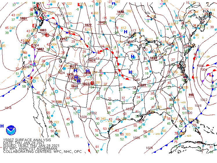
Well it seems the trough misses to the east a bit now. The deepest of the cold is over the area today. The upper low is moving through NE CT and NW RI right now in a few hours it will be south of Block Island and this will swing the band southward and out to sea. I expect the NWS to cancel the Winter Weather Advisory. I am skeptical about the FEB 1-3 2021 event being snow on the Cape.
-
7 minutes ago, 40/70 Benchmark said:
Another half inch today...
What is that area of rotation on radar that is moving southward in the Gulf of Maine? It is east of Cape Ann now
-
What has developed off of Portland Maine over the western Gulf of Maine and is moving southward? It looks like the beginnings of a northerly fetched band of snow.
-
The biggest difference is that cold air has arrived and you can feel it outside.
-
5 minutes ago, SouthCoastMA said:
Yeah actually starting to stick finally. It was snowing all day but little to show for. Maybe we grab an inch before tomorrow
The band is being enhanced by the Bay. The precipitation is blossoming. 18z GFS was west with the H5 low as it travels over RI. This brings the band inching west a bit.
-
Cold air has arrived and so has the ocean enhanced snows along the trough/surface boundary. Temp is 30F
-
6 minutes ago, The 4 Seasons said:
Watches up for Jimmy!
God bless.
thanks, I think more snow will fall
-
2 minutes ago, ORH_wxman said:
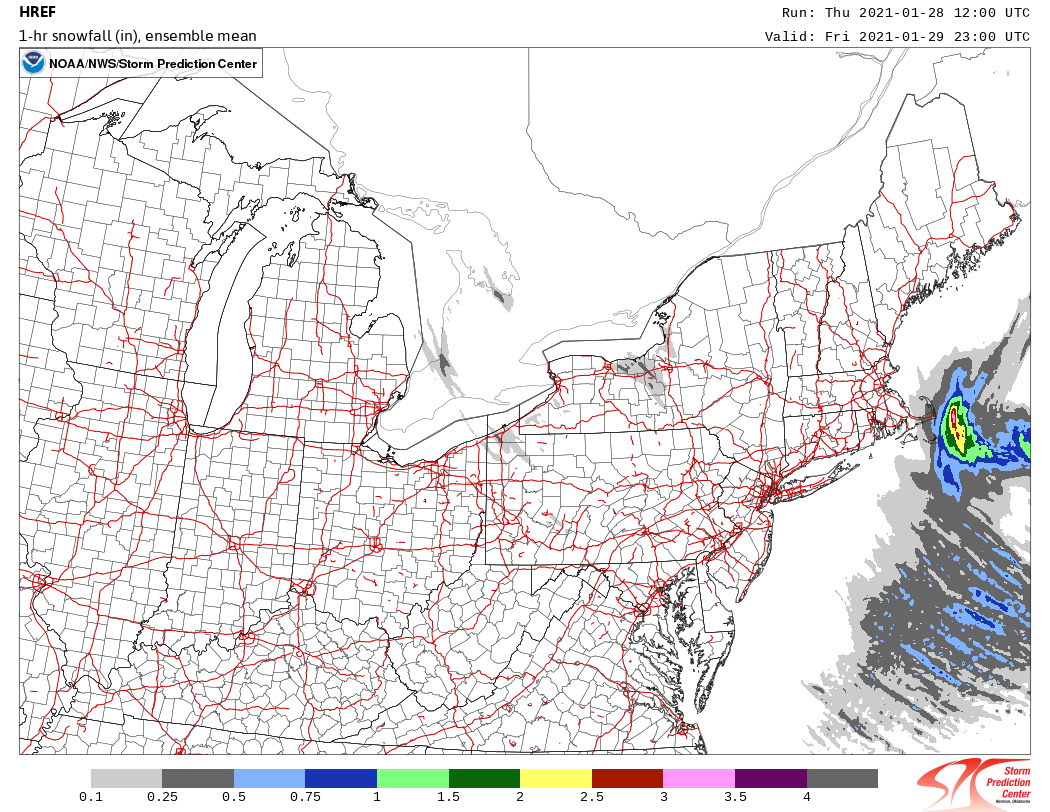
3km still hits the outer Cape decently tomorrow.
Honestly all the 18z guidance were west a bit with the upper low over NW RI and also the trough is stronger and the banding is stronger!
-
1 minute ago, ORH_wxman said:
3km still hits the outer Cape decently tomorrow.
Winter Storm Watch in effect for tomorrow for Barnstable and Nantucket
-
Our Polar Vortex is moving southeastward now over Quebec, Canada
-
Just now, OceanStWx said:
I assumed it would be easier to find, but alas no luck, but 12/9/2005 would be a more classic fold I believe. But it's been a while since I've seen cross sections.
Yeah that storm, brought a microburst through the entire length of the Cape
-
1 minute ago, OceanStWx said:
I wouldn't say it is. You aren't really getting the tropopause to fold under the upper jet. It's more of a tropopause polar vortex (TPV) that has dislodged.
Oh okay,
-
Just now, OceanStWx said:
Climb up into the crow's nest and sniff the ozone.
Is this not a tropopausal fold type event?
-
Just now, OceanStWx said:
Look at the position of the low pressure. Inverted trofs are inverted because the pressure trof extends north from a low pressure. With a low pressure this far south, the approach of a shortwave from the north orients the inverted trof more north/south and mostly offshore. As the low continues out to sea and the shortwave ends up over SNE, the inverted trof axis will end up aligned more NW/SE and allow some of it to make it inland.
Typically a low pressure much closer to SNE and a shortwave approaching from the N would allow the trof axis to be more NW/SE from the start and much more likely to impact coastal areas.
But you are also likely seeing impacts from a storm closer to the coast.
-
The likely reason for the different movement of the echoes over eastern New England is due to the upper divergence caused by the southeast quadrant of the upper low over Ontario and western Quebec that will be rotating southeastward towards the region. The upper divergence will allow the surface low to intensify, therefore intensifying the band of heavy snow.
-
Just now, OceanStWx said:
Honestly, it will probably be effing wild for anyone out fishing. It should at least partially make it onshore, but the best of it will be mostly for the fish.
Man I would love to witness those conditions and get them on camera live. I mean just once, I want to witness something that extreme.
-
Just now, OceanStWx said:
I think it will clip the Cape too, but it's really the inverted trof reorganizing to our east later tonight (in a northeast/southwest fashion) then getting captured by the upper trof diving through SNE. So that intense band of snow is actually going to form up in the Bay of Fundy tonight and come crashing southbound.
Is it because the upper trof is not situated ideally and not as far southwest?
-
Just now, ORH_wxman said:
Bummer...prob 2-3F cooler there and you couldve grabbed a couple inches.
Will that arctic air is moving into the region. Man those 850mb temps drop to -24C on the latest RAP run
-
1 minute ago, OceanStWx said:
So close, yet so far away.
You know what becomes our mesolow is this feature over the Cape Cod Bay right now. This little low shifts offshore and then backs in tomorrow. This low intensifies as the H5 low approaches and transfers energy to the coastal low. This process is what develops the intense band of snow and wind. Honestly, current trends do not show this feature moving out as promptly as the models have suggested. I think the band moves over the Cape. Just a hunch, similar banding impact as the DEC 20 2010 system.
-
6 minutes ago, The 4 Seasons said:
i saw CQX reporting light rain and 40 last hour, whats going on right now in Harwich? same?
Oh we will get colder once the trough or boundary begins to move east. Right now the area of best convergence is over the Upper Cape and southern portions of Plymouth county. I honestly think tomorrow is going to be a lot of radar hallucinations and a lot of huh, and ooohhh, and then some bickering and then celebration as the monster band does hit us right on the noggin.
-
5 minutes ago, The 4 Seasons said:
i saw CQX reporting light rain and 40 last hour, whats going on right now in Harwich? same?
A few degrees colder, but rain as well.
-
Just now, CoastalWx said:
It will hit, but I think just a 1-2hr period of heavy snows and winds. Maybe 2-3" if it goes right.
What does a strengthening H5 low lead too?
-
 1
1
-
-
Just now, CoastalWx said:
Yeah Tip's caressing Nape Rays melted some of the stuff exposed to solar radiation.
Scott, do you think confidence is decreasing for the norlun band tomorrow hitting the Cape?
-
Just now, Damage In Tolland said:
Cane?
???
-
 1
1
-
Jan 26-27 light snows
in New England
Posted
that band looks west across the SE Maine coastline