-
Posts
8,736 -
Joined
-
Last visited
Content Type
Profiles
Blogs
Forums
American Weather
Media Demo
Store
Gallery
Posts posted by USCAPEWEATHERAF
-
-
Just now, Baroclinic Zone said:
Phasing what? Itself?
Maybe amplifying is a better term to use, Deepening shortwave!
-
-
1 minute ago, weathafella said:
A subtle but distinct slowimg of start and end time on today’s guidance
Jerry, that shortwave will be phasing when it reaches the benchmark region. The surface low will be going through its best intensification process in that moment. It will seem like a slow down, and all the HIRES and globals are all snow for the Cape. ACK is a different story.
-
 1
1
-
-
Even though the 2/6 NAM is further south with the track near the BM compared to the 2/5 run, it is a quite a bit stronger at the surface center
-
Wiz, Kev, this storm is quite impressive down south. Numerous lightning clusters throughout the eastern Florida waters, over Florida and along the central and northern Gulf coast. Also the southern stream system is quite dynamic producing its own convection and lightning. Also, the system is being aided by two areas of vorticity merging. Our surface low is very broad with surface pressures in a large area of 1008-1010mb.
-
 1
1
-
-
They don't think the Outer Cape will snow much because it occurs during the day, and the warmer ocean layer will allow stronger warm air advection out ahead of the storm will preclude snow accumulating and they believe the storm will be robust enough to bring in warm air. I think the dynamics will offset the little warm layer at the boundary layer and instead the intense lift and best snow totals occur over the Cape. ACK will mix.
-
Just now, Henry's Weather said:
BOX has me mixing. Any reason for this I missed?
Don't pay attention to it, no guidance has mixing pass ACK.
-
 1
1
-
-
Just now, trat said:
I Should say expanded N of Bo's.
They must be blending with their surface observations down south and realize the models are not initializing this system well at all. That disturbance over AR and eastern OK and TX means quite the business, it is showing tremendous lift on the southeast flank.
-
I am not buying the rain this time, especially with the dynamics this system brings and the track it take. Now if it was southwest of me, then sure, but this is south and southeast of me, all snow for me. ACK might mix, I am not.
-
 1
1
-
-
1 minute ago, STILL N OF PIKE said:
Well, im routing for you James, but i wouldn't bet against the NWS.
I would LOVE the Northern stream to stop slowing down and acting as a kicker. But given the trends last 12 hours i would guess messenger tickle east or two from here on out and this ends up a i-95 storm for S CT/ Central/ E Ri/ SE mass (Bos SE) .....but that is based on the assumption we see some East tickles
The ceiling and accumulation goal posts for SNE ... on this looks higher than usual ..given how it's juicy and gets strong quickly...
That is the only reason I see why the Outer Cape would rain is the storm is stronger and produces a more intense low level easterly jet, but the dynamics offset any boundary layer warming as the models show that at 925mb the temps are below -3C and 850mb below -7C. That is plenty cold for all snow even on the Cape. Also omega approaches 40 microbars in the Dendritic Growth Zone (-12 to -18C).
-
1 minute ago, STILL N OF PIKE said:
IS this compared to forecast or just a observation not related to modeling
Bc there has been something getting this to Tick se on modeling...nothing major just small moves..like maybe N stream acting as kicker
Nam was the last zonked model to go SE....12z looked beautiful and Euro was decent at 12z so would have been nice to see nam not cut totals in half for 495
It's a close situation...i could see this come back another 25 miles NW or do a few more east tickles
It is an observation, looking at the H5 mesoanalysis page at H5, it shows the orientation of the northern stream trough being positive and the southern stream is east of the trough axis. Again, rain is not happening here, maybe CHH and the National Seashore, and maybe ACK for a bit, but the latest NAM guidance shows all snow.
-
1 minute ago, weathafella said:
Lol....I finally noticed SV changed their scale. My excitement went up a notch!
the freaking NWS just issued the updated statement with the WSW for the Cape, they are now expecting mostly rain on the outer Cape with 1-3" of snow now expected. What is the crap with this? Why such a warm forecast?
-
 1
1
-
-
Current 500mb charts on the SPC mesoanalysis page suggests that the southern stream system is out ahead of the northern stream.
-
-
1 minute ago, weathafella said:
My vendor shows qpf of 0.75-1 on the cape and ACK tickling 1.25.
Nope, mine does not
-
The 1.5-2.0" line tickles Monomoy Island south of CHH. It also engulfs ACK!
-
 1
1
-
-
6 minutes ago, SouthCoastMA said:
It's further SE this run
Yes it is, but it closes off at H5 southeast of NYC. Time for it to trend more intense.
-
The trailing shortwave is slower which allows the southern stream to slow a tad and maybe amp more as it swings southeast of ACK.
-
While the overall system is a tad southeast at H7 on the 18z NAM compared to the 12z, it is more amped and closes off a low southeast of NYC at hour 24
-
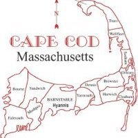
6-12" for the Cape and Islands, someone on the Cape and maybe the Vineyard will see the most persistent deformation banding that smokes them for the entire duration and we get an absurd total. That area is most likely Harwich to Hyannis, Sandwich to Bourne, or the Vineyard.
-
Our disturbance is digging southward over OK and TX. Our surface low is developing over the Gulf of Mexico. Convection is developing over the central GOM.
-
Surface cyclogenesis beginning to take place over SE Coastline of Texas or just offshore as the primary low is weakening over central TX.
-
 1
1
-
-
2 minutes ago, JC-CT said:
WRW?
Joking
-
2 minutes ago, BombsAway1288 said:
Don't think you want it too strong Jimmy. The stronger the storm, the more amped it will be likely.
You're sitting pretty right now. Would probably want it a few degrees colder at the onset so when it does wetbulb down, you're not seeing white rain for hours.
The dynamics cool the column from the top down.


Quick Hitter Coastal Threat, Feb 7-8th
in New England
Posted
Surface map and the surface pressure tendency maps suggests our surface low is developing southeast of Savannah, GA.