

USCAPEWEATHERAF
-
Posts
8,736 -
Joined
-
Last visited
Content Type
Profiles
Blogs
Forums
American Weather
Media Demo
Store
Gallery
Everything posted by USCAPEWEATHERAF
-

March 12/13/14 Blizzard/Winter Storm/WWA etc
USCAPEWEATHERAF replied to Bostonseminole's topic in New England
That easterly inflow currently happening into the coastline should continue another three more hours as the mega band moves towards the coast from the west it will combine with banding over the Cape and produce 2-4"/hour rates for a few hours as north winds enhance the snow bands gathering moisture off the ocean -
March 12/13/14 Blizzard/Winter Storm/WWA etc
USCAPEWEATHERAF replied to Bostonseminole's topic in New England
I think we catch up to you guys later tonight when the death band reaches us I hope it strengthens and stalls over the Cape for about two to three hours then I could get to two feet and not call this a waste of a storm -
March 12/13/14 Blizzard/Winter Storm/WWA etc
USCAPEWEATHERAF replied to Bostonseminole's topic in New England
It's pouring snow over my head -
March 12/13/14 Blizzard/Winter Storm/WWA etc
USCAPEWEATHERAF replied to Bostonseminole's topic in New England
Conditions are the worst now in the storm blizzard conditions -
March 12/13/14 Blizzard/Winter Storm/WWA etc
USCAPEWEATHERAF replied to Bostonseminole's topic in New England
31F with a north wind -
March 12/13/14 Blizzard/Winter Storm/WWA etc
USCAPEWEATHERAF replied to Bostonseminole's topic in New England
I made a very poor judgement on my snowfall map, I trust the models too much and you get burned -
March 12/13/14 Blizzard/Winter Storm/WWA etc
USCAPEWEATHERAF replied to Bostonseminole's topic in New England
I just measured, there is melting going on here, 4.5" of snow, should get colder and better ratios second half of storm as comma head comes through with 3-4"/hour rates -
March 12/13/14 Blizzard/Winter Storm/WWA etc
USCAPEWEATHERAF replied to Bostonseminole's topic in New England
Oh ok, that must be the latest update then, thanks dendrite -
March 12/13/14 Blizzard/Winter Storm/WWA etc
USCAPEWEATHERAF replied to Bostonseminole's topic in New England
Chatham, MA Municipal Airport's last observation had only .62" of QPF measured so far, that means if models were right, we have another 1.9" of liquid precipitation to go in this storm -
March 12/13/14 Blizzard/Winter Storm/WWA etc
USCAPEWEATHERAF replied to Bostonseminole's topic in New England
Good to solid inflow out of the southeast currently, really moistening up the dry slot and producing heavy echoes to stream into nantucket -
March 12/13/14 Blizzard/Winter Storm/WWA etc
USCAPEWEATHERAF replied to Bostonseminole's topic in New England
Pretty bad, our power was flickering earlier, we have had some good rates since I last guessed at snowfall amounts, I will officially measure at 12pm today -
March 12/13/14 Blizzard/Winter Storm/WWA etc
USCAPEWEATHERAF replied to Bostonseminole's topic in New England
My backyard -
March 12/13/14 Blizzard/Winter Storm/WWA etc
USCAPEWEATHERAF replied to Bostonseminole's topic in New England
Snowing probably by estimate about 2"/hour this new band that has intensified over my head -
March 12/13/14 Blizzard/Winter Storm/WWA etc
USCAPEWEATHERAF replied to Bostonseminole's topic in New England
5" on the ground, 33F temp, NE wind gusting over 40mph, pressures around 985mb, pasty snow so far, temperatures should drop as the storm passes east of us. Storm should slow down some as it passes us to the east and reaches the benchmark to the east. Pressure in the storm has to be below 970mb, dry slot still a ways off, new banding developing heavy snow rates just off the Chatham, MA southeast coastline heading northwestward. Latest RAP brings another 1-2" of precip into the area. -
March 12/13/14 Blizzard/Winter Storm/WWA etc
USCAPEWEATHERAF replied to Bostonseminole's topic in New England
Snow has increased in intensity in the last five to ten minutes -
March 12/13/14 Blizzard/Winter Storm/WWA etc
USCAPEWEATHERAF replied to Bostonseminole's topic in New England
I'm between31/32 -
March 12/13/14 Blizzard/Winter Storm/WWA etc
USCAPEWEATHERAF replied to Bostonseminole's topic in New England
She has closed off at H5, watch for her to slow down her forward movement in the next 6-12 hours, possibly prolonging our snowfall -
March 12/13/14 Blizzard/Winter Storm/WWA etc
USCAPEWEATHERAF replied to Bostonseminole's topic in New England
Here is the radar I use from wunderground.com, classic southeasterly inflow jet on a major time nor'easter classic precipitation production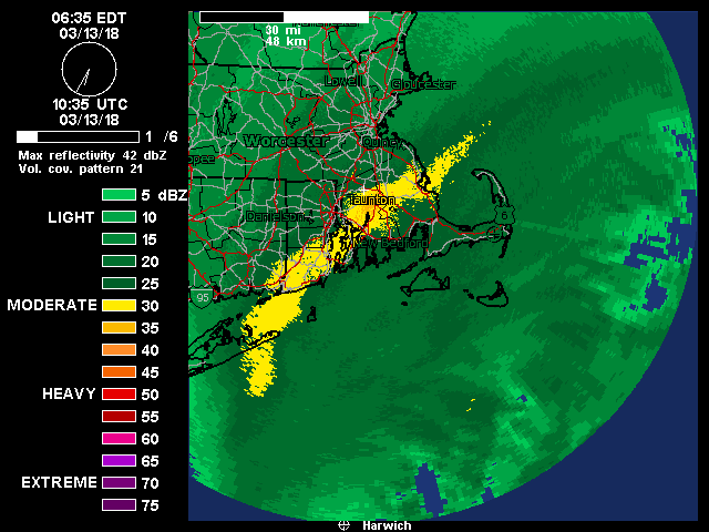
-
March 12/13/14 Blizzard/Winter Storm/WWA etc
USCAPEWEATHERAF replied to Bostonseminole's topic in New England
Snow is powdery in nature now, dry snow blowing around in the wind, we are around 30-31F -
March 12/13/14 Blizzard/Winter Storm/WWA etc
USCAPEWEATHERAF replied to Bostonseminole's topic in New England
Heavier banding developing in the SErly inflow -
March 12/13/14 Blizzard/Winter Storm/WWA etc
USCAPEWEATHERAF replied to Bostonseminole's topic in New England
Bands are weaker over the area right now, but wind is blowing the drying snow, as we get further into the storm -
March 12/13/14 Blizzard/Winter Storm/WWA etc
USCAPEWEATHERAF replied to Bostonseminole's topic in New England
03z SREFS went up big time with the mean at HYA, all snow now with a QPF mean of 2.5" and a snowfall mean of 20", mainly members are between 15-25" of snow -
March 12/13/14 Blizzard/Winter Storm/WWA etc
USCAPEWEATHERAF replied to Bostonseminole's topic in New England
Surface pressures at buoy 44008 SE of ACK showing pressures of 982mb, and falling extremely rapidly -
March 12/13/14 Blizzard/Winter Storm/WWA etc
USCAPEWEATHERAF replied to Bostonseminole's topic in New England
We lost power for a second there earlier in the morning around 545am, we switched over to very heavy snow, about 1-1.5" of snow on the ground now, temp hovering around 32F now, snow is sticking to everything, this is not a bust forecast, these amounts will happen, stay with us, look at that band converging towards Boston, MA we have hours of southeasterly inflow into the band allowing more heavy snow bands to infiltrate the region. She should slow down her forward progress some as the Arctic trough gets a hold of her -
March 12/13/14 Blizzard/Winter Storm/WWA etc
USCAPEWEATHERAF replied to Bostonseminole's topic in New England
Damn I was falling into bad habits, I am sorry

