dta1984
-
Posts
1,777 -
Joined
-
Last visited
Content Type
Profiles
Blogs
Forums
American Weather
Media Demo
Store
Gallery
Everything posted by dta1984
-
Speaking of a couple of inches of fluff snow lol..... looks like 1-2" out there. Snowing nicely though..
-
Feels pretty nice outside. I don't think the Euro has been performing well as of late. Quite the change.
-
Looks like some general agreement for 3-6", though placement is a little different between models.
-
My thoughts exactly! One last storm and let's move on. If only there was some consensus on this track lol.
-
Ya, as I was out last night I noticed there sure didn't look to be 5" on the ground. My driveway had bare spots, then spots of 4" which was probably mostly wind blown. The surface of the deck was definitely the coolest.
-
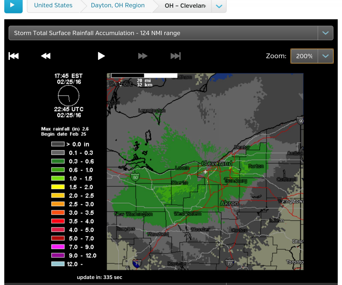
Radar estimate shows the east side near Solon, then ne from there did well. Though ...probably not the most accurate.....
-
I've got 5.25" on my deck. Definitely more than I was expecting.
-
Ripping pretty good in Solon. I'd guess 2" down. Home Webcam shows what appears to be the same.
-
Yep, hopefully it will improve. There are a few yellow moderate pockets starting to show up as it shifts east. Didn't measure this morning, but probably 1/2" in the grass.
-
Map from cle is a general 3-4" across the area. Seems like a good call. A few models had 6" spots in the Snowbelt. http://www.weather.gov/cle/Winter_Weather
-
It is definitely getting more interesting. Seems the trend has been back to the east a little since yesterday. Several models put 3-6" near cle. Could be a nice storm if there's a little more enhancement to top it off.
-
Torching at 65 degrees. Feels great outside!
-
The great melt begins today. A few days of temps near 50 or better, and lows above freezing should have no problem wiping out the snow. As of yesterday afternoon, the depth on my deck was just below 12".
-
Fairly strong band approaching. The end of this may put down a quick 1/2".
-
Same here. Should really compact the lake effect fluff underneath.
-
Their new map looks better. Wwa out for east of cle for 3-6". Seems reasonable, but a few more ticKS nw and could be pushing the upper limit.
-
Exactly, hopefully we benefit this time. The RAP has an 8-12 weenie band through cle. Then again. ..it's the rap lol. Edit; so does the hrrx.
-
The short range models aren't horrible, but the 6" line looks to stay slightly se of here. Maybe this will trend in our favor. Had a light coating of snow this morning, but didn't get a chance to measure. Guessing .5".
-
Picked up am additional .5" last evening / overnight. Looks like we may salvage a few inches from the early week storm. After that, things warm up some. Hopefully enough to break up any ice that formed on the lake.
-
Looks like 3" fell overnight. A lot of wind, so hard to measure. Persistent light to moderate snow showers the past few hours. Tiny flakes, not sure it'll amount to much.
-
This kind of snuck up. 3-6" sounds good. Euro showing us love for next week. I'm going to add .75" to my totals for snow that fell after I left this morning. Lake effect = 15.75" Since Monday = 18.75"
-
Kind of curious what the airport will report today. I believe they have been under a band for a while.
-
Wasn't there a report from shaker yesterday? Based on the radar last night, I'd imagine the 271 area from 422 to near 322 were similar. Yep, looks like it's snowing good again!
-
Awesome congrats! There was a pretty large area that got 8"+.
-
Looks like 6.25" additional since 6pm yesterday. The majority of that fell between 6-10pm. Running total is at 18" since Monday. Depth on my deck is at 15". Also should specify I'm including 3" that fell before the lake effect in my totals.