ryan1234
-
Posts
357 -
Joined
-
Last visited
Content Type
Profiles
Blogs
Forums
American Weather
Media Demo
Store
Gallery
Everything posted by ryan1234
-
Just a friendly reminder that there is an actual observation thread.
-
I agree it is strange, but I expect more counties to be added at some point. CAE is always more conservative.
-
Lancaster County, SC is now under a Winter Storm Watch. It was previously under an advisory. Makes me feel slightly better about there being less of a warm nose for the CLT metro.
-
What I find a bit interesting and it most likely will have nothing to do with our area, is how the WSW's and WWA's have shifted quite a bit south in TX and OK. Before OKC was expecting 4-8 inches, that has gone down and that line of heavier snow has shifted to the south.
-
Given the current trends, I really feel confident that most of us are in for a nice surprise. Granted, I’m merely an amateur, but I really feel like this CAD is going to over perform. Sure, there is plenty that could go wrong. But I think the overall consistency speaks volumes. .
-
I’m about 14 miles away, as a crow flies. So, I’m at least at the lower end of that range. Wouldn’t it be nice to have a snowstorm that doesn’t have a warm nose from the CLT Metro to the Triangle? Unfortunately, that is our climatology.
-
So, I am curious about something. I've always noticed on some of our bigger storms that places like OK and AR seem to get snow as well. Sometimes extending to TN. Is what happens with their snowfall amounts worth noting and getting an idea for what we will receive? Like overperformance or snowfall farther south?
-
If there is ZR or IP all the way down to the NE ATL burbs, then there is no reason why Charlotte couldn't say all frozen.
-
This just proves that the models still don't have a complete grasp on how much cold air will be available and how strong the CAD will be. Do I think Charlotte, Raleigh, or even the Triad will see close to 2 feet of snow? No, I don't. Though the Triad stands a slightly better chance. But it also doesn't mean that some of these big totals won't come to fruition even for CLT, RAH, and even GSP. Heck, NE suburbs of Atlanta may end up ZR and maybe some backside snow. There is still soo much time left to go and so many more model runs to go through. So stay within close proximity to the "cliff" but it's way too soon to be standing with one foot off or jump.
-
98% of the time other board members either end up posting said maps or at least offer a PBP for all of us.
-
Good lord, can we please stop with the "how about my backyard" questions? You all know how to read and know that maps and very detailed discussions will eventually begin to surface. I hope the mods can get a hold on some of these posters. Enough is enough!
-
Folks, we still have 3-4 days before this storm really gets going. As we all know, there is so much that can change between now and Sunday. Posting a NAM or GFS snow map and saying "it's all over for your backyard" and yada... yada... yada, does not belong on this thread.
-
Not saying you’re wrong, but at this point in time, it’s hard to go against the current trends. Of course that could change for better or worst. What burger said pretty much hit the nail on the head as far as this storm goes. .
-
Question: Does Atlanta's higher elevation assist at all with wintry precip in these kinds of setups? Or is it a moot point?
-
I'm with SnowGoose on Atlanta being completely thrown for a loop, especially if our CAD overperforms. If the Euro is to be believed, I'd imagine some ZR issues, for sure.
-
Now that's more like it! Looks a lot better for the Upstate and the CLT metro to the Triad. Would love to see those higher totals move a little east so our Raleigh peeps can cash in.
-
Almost as much as I would love to see a historic snow, I would also love to see the Mods really begin to start really hone in on some of these nonsense posts.
-
Cheers to that friend. For once, I'd like to see that warm nose get extinguished and never make it past Kershaw or Winnsboro. We are so overdue!
-
Having that transition line right there at SC Highway 9 is still a bit worrisome. I'd like to see it 50 miles south of there, at least for the CLT metro.
-
I really hope that, for once, the majority of us can score a decent snow this go around. I’m just over the Mecklenburg County line, near Matthews. So I know the frustrations of being east of I-85. If the Euro is to believed, I think a lot of us will be beyond ecstatic. I’d love to see snow all the way down to the midlands, the Atlanta area, and well into the Sandhills. I truly wish everyone on this board the best! .
-
Not every storm is going to produce the same outcome. And we are all well aware of this notion. Yet, here we are, lol. No one in Atlanta thought they were going to measuring snow if feet 4 days out.
-
It baffles me that people are already jumping off the cliff and are able to seriously call this storm a bust when we are still 4.days.out.
-
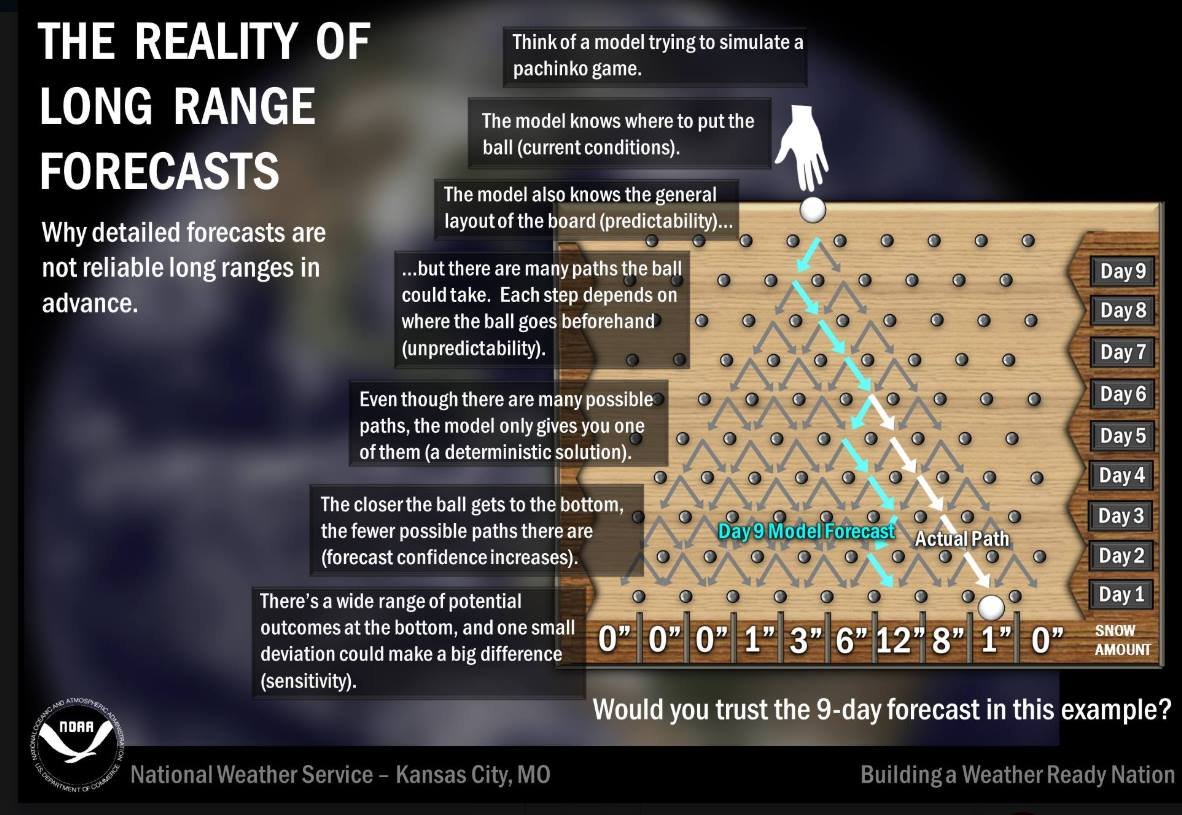
Brad P. posted this earlier today and I think it very well explains what could go wrong (or right) when it comes to model accuracy. We still are technically 5 days out. Climatology speaking, the odds are against a blockbuster winter storm in December. It would be a rarity. But there is still so much time and cliff diving is premature. As is reeling a particular model in. I’m just excited to have a possible storm to track, that for the most part looks promising for a lot of people. .

-
Exactly, a lot of pieces have to come into play in order to get winter precip in the SE. The fact that we are able to track something this early on bodes well, IMO.
-
While you may be right, it's also way too early to make bold statements like that. It was only last year that the Atlanta burbs got over a foot, around the same time.