BlizzardWx
-
Posts
463 -
Joined
-
Last visited
Content Type
Profiles
Blogs
Forums
American Weather
Media Demo
Store
Gallery
Everything posted by BlizzardWx
-
And like any relationship, it can always be overwhelmed by other factors working against it. I think @bluewave may have had the right idea that as teleconnections change with cc, potential connections like this become less reliable.
-
The only case I've seen that sort of supported it was in the Pacific in maybe 2014-2015 or so. I recall numerous fall typhoons directly helped to pump up a big western USA block that just kind of persisted most of the fall and winter after it set up. Of course, maybe that was going to happen anyway, but at least the connection was more obvious. To me, if the ACE connection is real, it would probably matter where the ACE is accumulating, as it could be indicative of something larger in the background state. That would mean its a symptom but not a cause. I could at least entertain that.
-
What is the reasoning for why ACE would matter so much for the winter pattern? It's kind of hard to accept at face value that any heat transfer now would matter say 3-6 months later. It also seems like the ACE calculation is flawed since it doesn't take storm size into account. A little storm like this is treated the same as a much broader one right?
-
I wonder if this correlation changes at all with the strength of the ENSO event. It's going to be a fairly weak event in terms of ENSO, so perhaps the correlation won't be as reliable. The weakest example you showed for 16-17 didn't match the expected pattern. I guess it may depend on what is driving it. I suppose the -PDO implies the atmosphere thinks its la nina regardless of ENSO, at least to some degree.
-
Looks like the odds for an upper end arctic outbreak into my area in the southern Plains will be elevated once again this year. It doesn't always work out to get a lot of snow with those big hits, but that is a look that favors 1 or 2 significant cold events here.
-
Yeah I can see those. Thanks!
-
For some reason I can never see your images. It's always just something like "3aa-14.png". Does anybody else have this problem? I don't comment much, but I always appreciate reading all your comments as well as everyone else's.
-
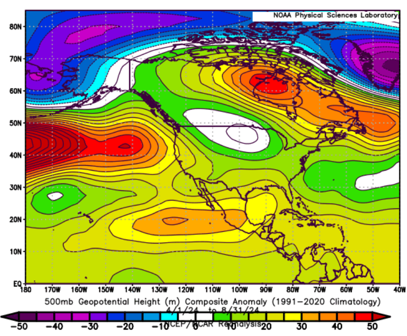
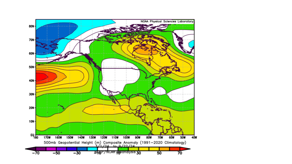
Like some others noted, I have also seen a loose correlation between warm season patterns and the eventual winter outcome. It's never in the exact same place and the amplitudes change (etc.) but usually there are hints of what will eventually occur. Here is what we had for April to August. Obviously the pattern that developed since then has been very different but maybe this map will still have some seasonal forecasting utility.
-
I'm encouraged if we can even just get the MJO rotating through the cooler phases at this point. Obviously no guarantees of anything, but at least in my mind it means a better chance of doing it again in the winter and at least some windows for winter weather.
-
That's the thing, I don't! I mean, I do think it probably has the right idea overall (especially over a trimonthly average), but its the details that will make or break a winter and we just can't tell those things yet.
-
Euro seasonal is, at least on average, horrible down here with above normal temps all winter. At least precip is close to average. With the large AK ridge, I assume we'd probably get a cold snap or two when it occasionally amplifies enough.
-
Down here we've done a little better, but it's still been pretty bad. Since 15-16 the seasonal totals have been: Long term mean of 8.7" 15-16: 3.0" 16-17: 0.7" 17-18: 2.1" 18-19: 2.9" 19-20: 3.1" 20-21: 15.8" 21-22: 12.0" 22-23: 2.0" 23-24: 1.6" That's 5/7 with less than 50% of normal. The 43.4/78.3 inches over that stretch is about 55% of normal snow. I was in Phoenix for 2019-2022 and then in Tulsa the last two years. So I've only seen about 3.5" of snow in 5 years. There have been a few sleet and zr events in there but we all know snow is where its at! The patterns that help me to do well aren't exactly the same as most in this sub but they are at least related.
-
What's his handle over there? (for whoever knows)
-
Having grown up in the west (Portland OR) I can certainly speak to the feeling that things will never go back to normal and the anguish of multiple lackluster snow years in a row. Things do turn around eventually but decadal snow drought patterns are definitely a thing.
-
This is excellent news! I really think we as a community will be able to produce significantly better outlooks in the future if we do a better job controlling the noise in analogs. I'm looking forward to seeing what you come up with.
-
One thing I've had on my mind lately is that it would do all of us well to get the bigger picture of "analogs" and not get bogged down in extraneous details. I think seasonal forecasting skill would increase if we could do more to tie the specific anomalous features of a year to the type and magnitude of forcing they will produce. As a hypothetical example, "If la nina focuses at 150W it would favor a standing ridge at x longitude. But because of the west Pacific Warm pool it may be shifted further west...etc" That at least ties real features to real background forcing, which IMO is all we can really do at a seasonal level. I think if we can consider each individual feature, like throwing pebbles in a pond and seeing where the waves go or intersect, we might get a better idea of how things will constructively or destructively interfere, which forcing will dominate if they are competing, and so on. In borderline snow climates all we can really do is try to figure out if the background state will be reasonably supportive for winter weather or not. And to be clear, I do see some of you doing what I am saying we should do. I think my broader point is that it's very unlikely you will ever have a truly good analog year, and so although analogs can be useful with context, I think we'd be better off looking at specific pieces of analog years instead of the years as a whole. Anyway, that's my opinion. If I am wrong, that's ok too
-
At least in terms of observed weather this fall. It's interesting how dry it's been down here. 8th driest September on record at TUL and looks quite dry into at least mid October. Some areas down here have had more rain than the airport, but it was a dry month for sure. Looking at past years with similar levels of dryness, most of them were ENSO neutral years for whatever that is worth. I am unsure how this comparison would hold up over a broader area.
-
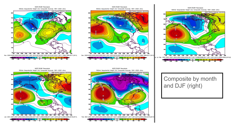
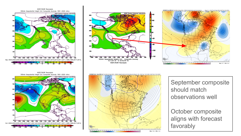
I don't have the expertise that you guys do, but for fun here was what I came up with for a preliminary guess at winter. I weighed ONI/MEI, PDO, recency, and pattern comparison. I didn't use solar as much since I don't know how much that actually matters. The composite of those years compared to this month and next looks reasonable: Usually there is some long term background signal with anomalies that rolls into winter, just shifted a bit. So what we have so far this year mostly lines up with the forecast, but might suggest a slightly weaker SE ridge than my composite had. It doesn't look good for the east, but maybe a little hope with that in mind. For me, I think the odds of an above average caliber winter blast are high, but snow will come down to the luck of the draw. However, most winters have been bad here for the last 9 years or so (7/9).
-
So what do we know about the "Atlantic Nina". Does that even matter for us in winter?
-
Good observations, and I've noticed the same things. I could live with that down here as we'd at least get some periodically interesting weather. The last two years have each had a high end cold wave in OK, but little to show for it in terms of snow.
-
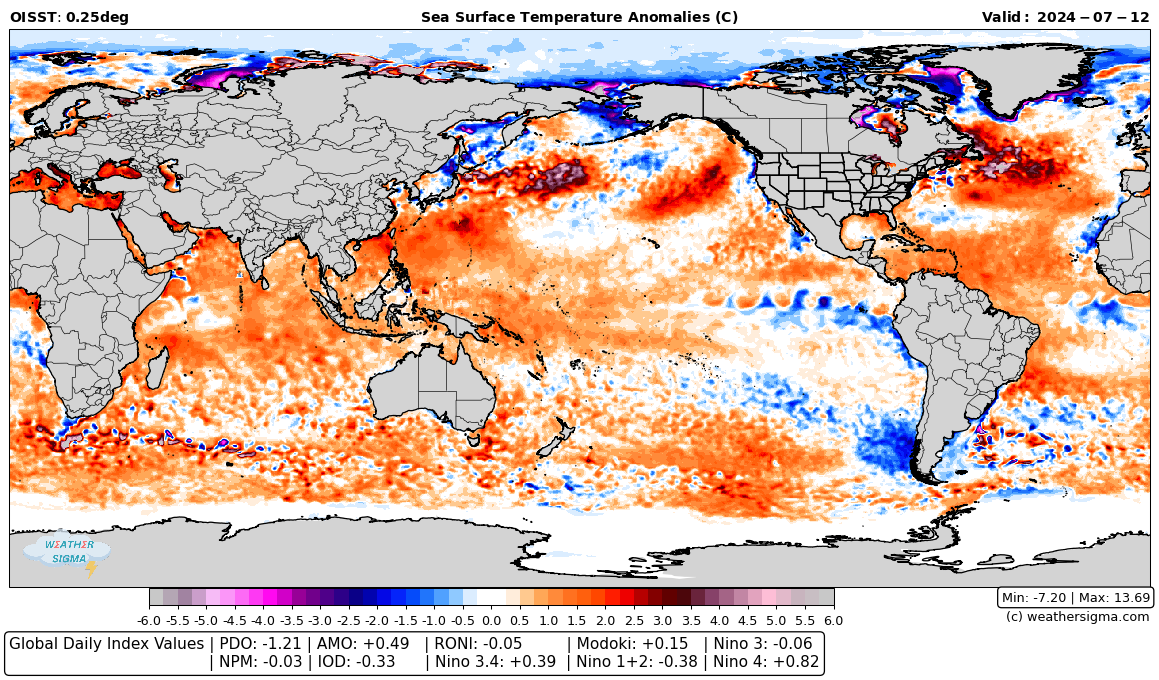
Sorry I've been away for a while. This feature shows up on other websites like wxbell that use that dataset. It seems to occur in places where climatologically there should be ice but there currently is not so its an artifact of the dataset. I can cover it up with a mask and it should be ok. But yes, I can also add the other areas you mentioned. It's no problem.
-
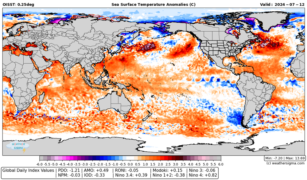
Here is what I have been working on for a sea surface temperature anomaly + (ssta based) index plot. It's possible some of the values are not correct yet and if you think so, let me know. But the idea will be that this is hosted and updates daily within a moth. I'll also do the atmospheric indices like I said.
-
This first part was just SST, but I am wanting to do atmospheric ones after I wrap up this up. I'll make sure to hit all of those!
-
Do you mean like a downloadable csv? So for I've got the pdo, amo, npm, nino regions, and roni worked out. I'll do IO next but beyond that I was hoping for input on what you all would find most helpful to have.
-
I'm working on a project to calculate a bunch of daily index values like the world climate service does for pdo, amo, etc. I'm curious what you all would find useful and any comments on how you'd like to see it presented.