BlizzardWx
-
Posts
429 -
Joined
-
Last visited
Content Type
Profiles
Blogs
Forums
American Weather
Media Demo
Store
Gallery
Everything posted by BlizzardWx
-
What is the website for these ENSO based MJO plot composites. Thanks in advance
-
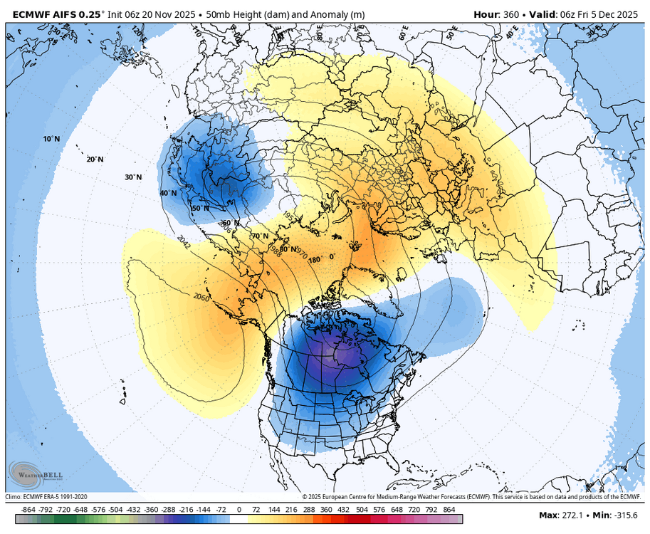
Some guidance wants to bring one of the PV lobes into North America. The 06Z AIFS does this near the end of its run, and unsurprisingly is building some very cold air at the surface at this same time. Obviously that is what we would want to see heading into December.
-
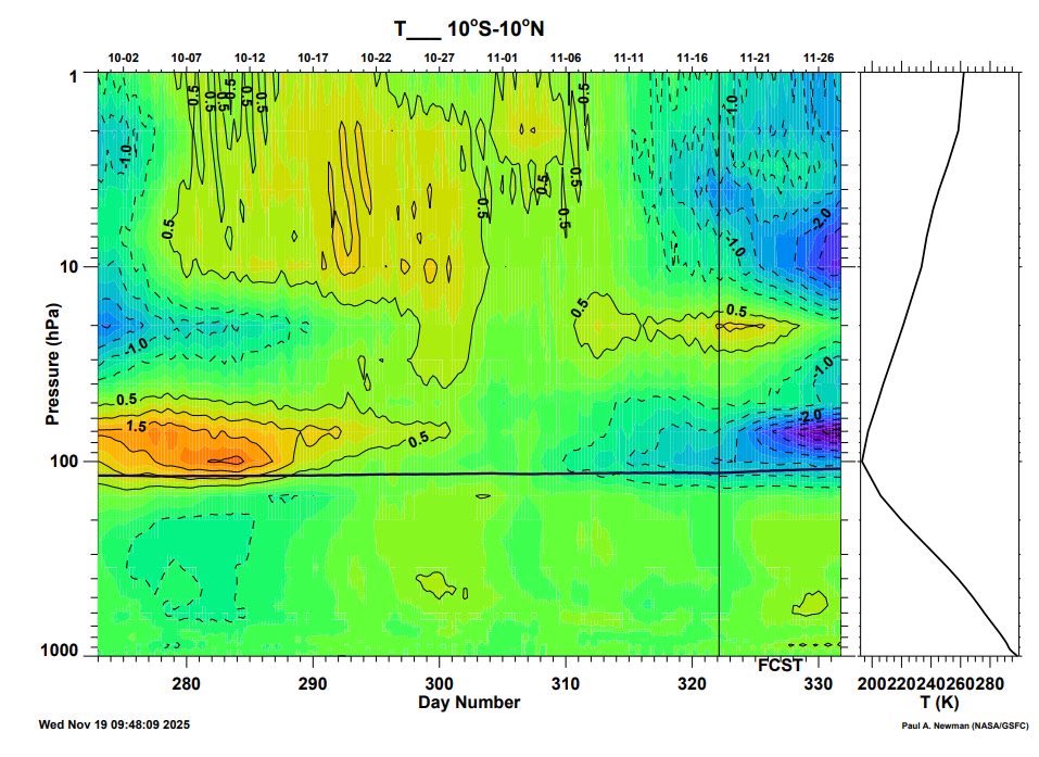
I saw this graphic on X from Eric Webb showing the cooling lower stratosphere in the tropics. It seems the trend in strengthening the MJO is likely related to models catching on to the effects of the stratospheric warming as well as the final warming at the south Pole (strengthened Brewer Dobson circulation). Perhaps this is what will finally allow us to see a robust MJO through phases 7-8-1.
-
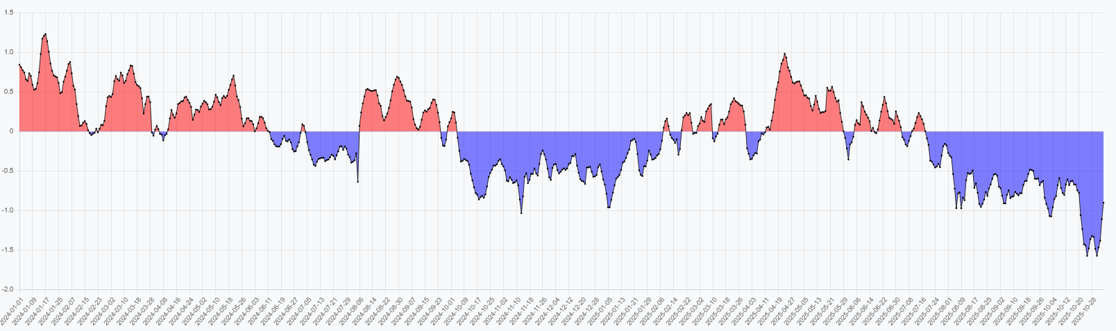
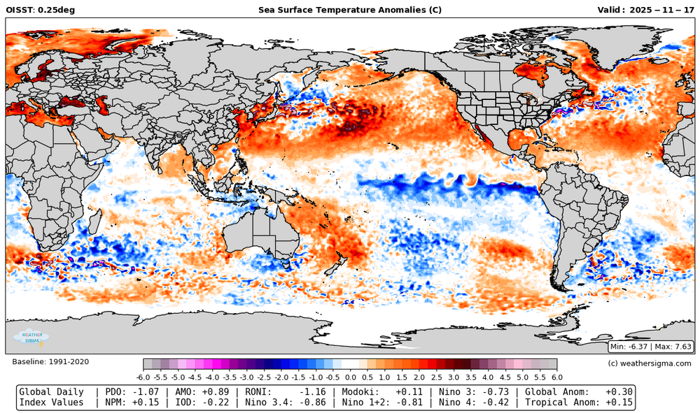
A lot has changed in the last month. Waters have cooled east of Japan and warmed in the east Pacific, a trend likely to continue. The PDO by my calculations is closing in on -1, and should rise further with this pattern. The -IO has collapsed. With some decent cooling near the MC, hopefully limiting MJO 4-6 this winter. The +AMO is strengthening but with a tripole pattern. RONI remains below -1. Global temperature anomalies dropped another 0.1 C in the last month.
-
https://x.com/webberweather/status/1990921925745410375 Webb says the tropical troposphere is already El Nino like. I wonder if this is playing into the strengthening trends for the MJO mentioned above.
-
Pretty deep vertically for areas with a wind reversal too.

-
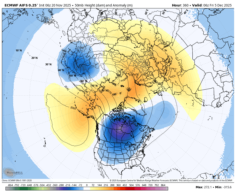
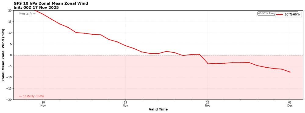
00z ECMWF at 50 hPa has a full PV split with 3 daughter vortices, one right over the US. That'll help heading into December.
-
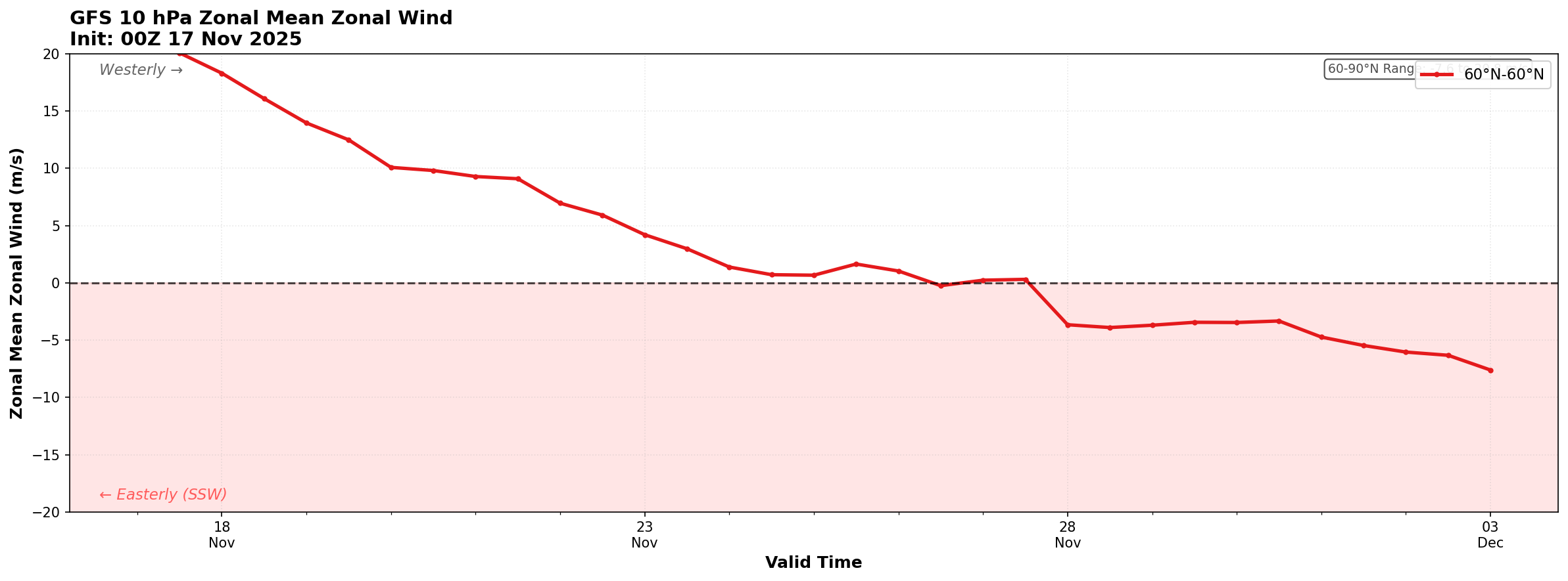
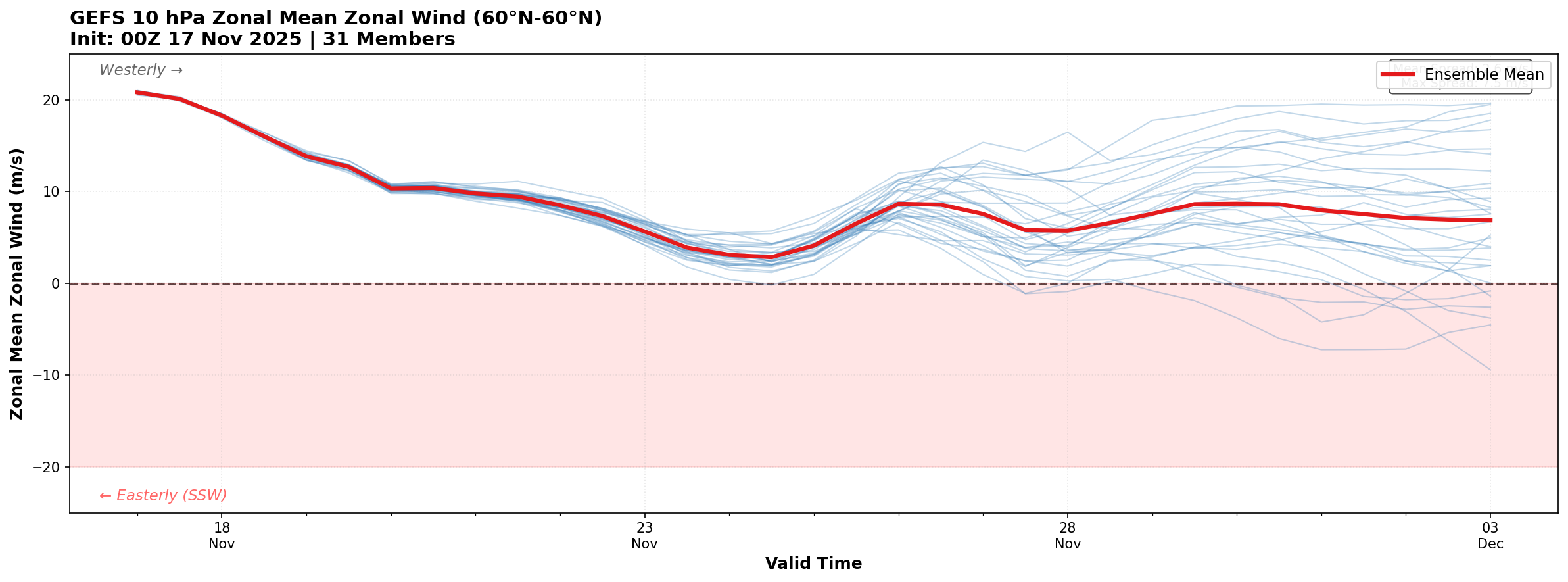
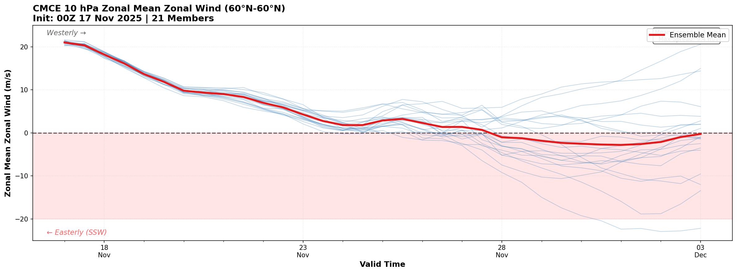
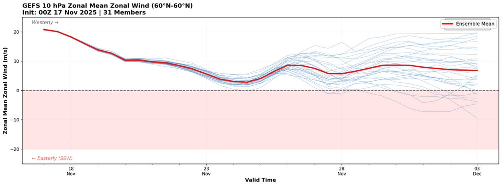
These aren't very polished, but for fun here is the GFS, GEFS, and CMCE 10 hPa zonal mean wind for the next 16 days. CMCE is on board with the SSW in the mean, GEFS is lagging.

-
Might be an ice storm pattern for my part of the world with cold air under cutting mild SW flow aloft
-
I was coming on here to mention this. It's showing up in the GEFS mean too.
-
Over my way it began when it stopped for you all. Snowiest February on record and the Oklahoma state record coldest temperature.
-
No, it's a daily value. It's gone down a good bit the last little while.
-
On my page you can plot the daily values for most of the indices anybody cares about. RONI is below -1.2 now. https://weathersigma.com/sst?i=RONI
-
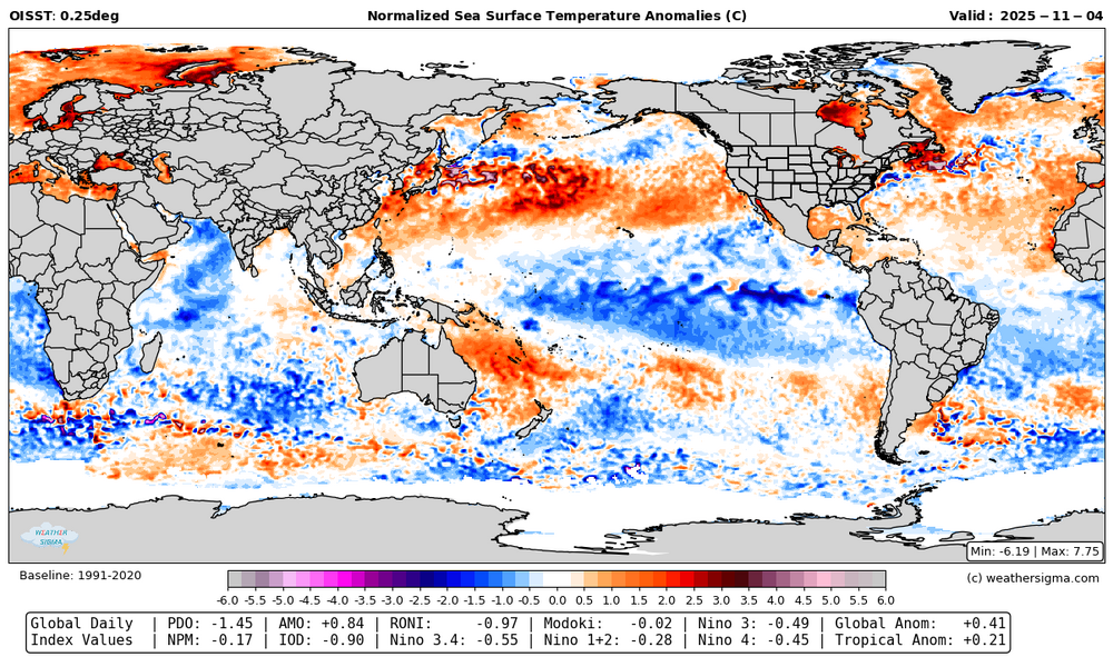
I've slowly been working on a weather model/ climate index page. I think it's far enough along to share. https://weathersigma.com/sst Within this tab you can select a range of dates to display. I've run it back to the start of 2024 if you want to check past data. Each map has a bunch of index values along the bottom. They don't perfectly agree with other sources but some of that is related to exact methodology, region of choice for the index, data set, and so on. My IOD doesn't run as cold as what I've seen on here, for example. If you find it useful, find errors, or it needs changes, let me know. But I hope it'll be useful. It updates daily like the world climate service site. The 2nd image is an IOD plot, which can be selected near the bottom of the menu.

-
I saw JB referenced @GaWx on one of his blogs and called him by name. Maybe JB reads all of the hate about himself on here too
-
The issue still remains why that occurred, but this does make sense otherwise.
-
I remember last year the mid level PV was often partly to mostly uncoupled from the lower level PV, or maybe it was just much weaker than the mid level vortex. Am I remembering that right? I wonder if there are any hints of that happening again.
-
FWIW this is exactly what I was talking about in my last post. People need to stop reading into what happened at exactly their house (mesoscale randomness) and assume it means anything in the big picture. That level of precision is noise and does not mean a pattern was good or bad.
-
I'm not sure exactly how you would do it, but I know I'd like to see more winter outlooks or past winter discussion focusing on snowfall potential rather than what fell at specific points when possible. Maybe another way to look at it would be to say is this objectively a snow producing pattern even if it didn't occur at Central Park (or wherever). If we could remove luck (mesoscale patterns) from more of our analysis I imagine it would be more constructive to discussion of the patterns at hand. I think some of what @donsutherland1 has been showing is kind of a step in that direction. You could in theory score a pattern based on its historical correlation to snowy patterns to say how good a winter should have been regardless of what actually happened at some point. Just a thought.
-
I do think the pattern coming up will favor slowly moving that warm pool in the central Pacific a bit further east with continued cooling influences east of Japan and along the west coast, at least for the next 2 weeks anyway.
-
I appreciate your views and everybody else's. I come here to see viewpoints from all angles. I'd say the same thing to you as well as everybody else, please continue to contribute. I value it.
-
Hopefully time to finally kill the -PDO and MJO 4-6 warm pool with that flip.
-
True. I do think ridging ends up a bit less amplified than last year, but I still think we see cold get a bit further south than what it has.
-
EPS weeklies try to bring the GOA trough back by the 20th of this month. But on the other hand they didn't see this GOA ridge until a few days ago. But considering this GOA ridge will probably be a dominant feature this winter I am not surprised to see it poking back up.
-
That was when one of the worst ice storms for northeast OK occurred. Please no