BlizzardWx
-
Posts
463 -
Joined
-
Last visited
Content Type
Profiles
Blogs
Forums
American Weather
Media Demo
Store
Gallery
Everything posted by BlizzardWx
-
2026-2027 Record-breaking El Nino
BlizzardWx replied to Stormchaserchuck1's topic in Weather Forecasting and Discussion
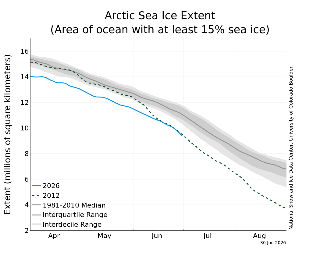
For all the talk of the arctic being cold, the sea ice hasn't got the memo, running near record lows. What I suspect, if the "cold" pattern continues, is that this will slow down heading into peak summer melt season like we've seen in the last few years. So we end up low, but not record low. On the other hand if melt off continues it would be yet another sign that something has indeed shifted.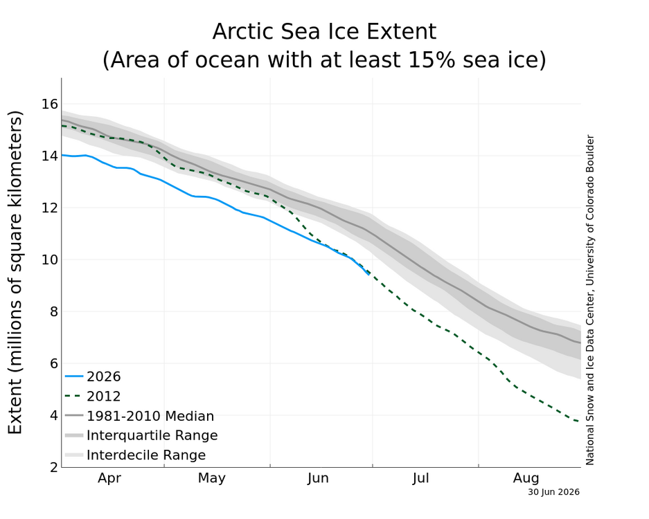
-
2026-2027 Record-breaking El Nino
BlizzardWx replied to Stormchaserchuck1's topic in Weather Forecasting and Discussion
I think extra cloud cover from more open sea area and thus evaporation is a good candidate. But its also plausible it could be traced back to the same patterns driving the west Pacific warm pool/-PDO that has been dominant over most of this same period. Interesting to think about anyway. I am not totally sure we cool that area below 30C but it is possible. Perhaps more likely is if the area to the east is enough warmer, along with the circulation you mentioned, it can at least put a lid on convection near the MC. Then you'd at least have the dominant forcing away from 4-5-6. -
2026-2027 Record-breaking El Nino
BlizzardWx replied to Stormchaserchuck1's topic in Weather Forecasting and Discussion
I think it IS pretty good right now for the most part. But I also think as the globe warms it will rise. It's really a function of lapse rates and a 30C surface is usually good enough to guarantee conditional instability for the time. But this ties back to my other post that a robust +IOD and +ENSO circulation could still cap it. -
2026-2027 Record-breaking El Nino
BlizzardWx replied to Stormchaserchuck1's topic in Weather Forecasting and Discussion
That is the question! I hope we can do it but I am still on the fence about whether it happens or not. -
2026-2027 Record-breaking El Nino
BlizzardWx replied to Stormchaserchuck1's topic in Weather Forecasting and Discussion
Yeah that is exactly what I was getting at. I am not sure if +30C is a magic number per say, as strong enough subsidence from a +IOD and +ENSO circulation might be able to keep a lid on it. But I do think the general idea is correct that if the surface is warm enough you will still get storm activity and forcing from that area. -
2026-2027 Record-breaking El Nino
BlizzardWx replied to Stormchaserchuck1's topic in Weather Forecasting and Discussion
If the entire system is too warm, even "below normal" can still be warm enough for convection to form. I tend to think that is what actually matters. If storms are popping near to above normal frequency near the MC you still have forcing. -
2026-2027 Record-breaking El Nino
BlizzardWx replied to Stormchaserchuck1's topic in Weather Forecasting and Discussion
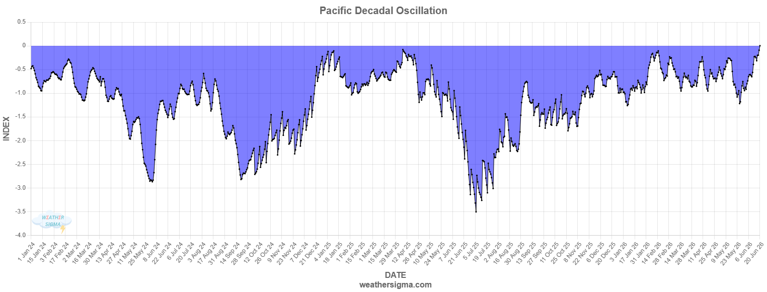
My numbers run slightly higher than WCS, and showing a rise back to around 0. Last year at this time we were tanking the value. In 2024 we were recovering somewhat after already tanking, but values were still much lower than now. In my mind its clear that things are really changing from where we've been the last 10 years. Yeah, maybe we aren't headed for a robust +PDO, but it feels like neutral to slightly positive could be in the cards.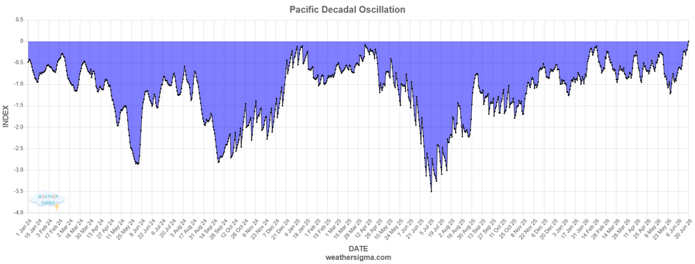
-
2026-2027 Record-breaking El Nino
BlizzardWx replied to Stormchaserchuck1's topic in Weather Forecasting and Discussion
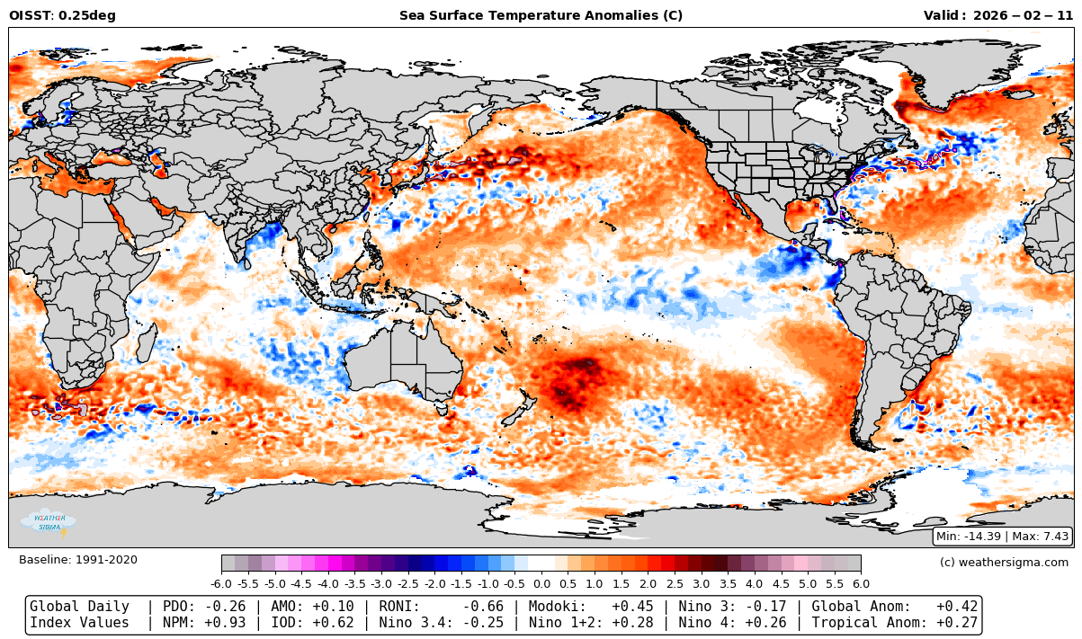
This is a good point because it may well be pretty similar to what we end up doing in the N Pac this winter, with warm water east of Japan AND along the west coast. Yeah its a problem when we only want to use recent years as analogs yet all of those years are biased towards -PDO and +AMO. That won't work when we buck the trend. -
2026-2027 Record-breaking El Nino
BlizzardWx replied to Stormchaserchuck1's topic in Weather Forecasting and Discussion
And it's worth noting it's not just really warm vs less warm. ECMWF seasonal shows genuine cool anomalies near the MC as part of that +IOD along with the eastward leaning nino. I think if this roughly happens it really would kill the split forcing Bluewave is always talking about. Even further north the ECMWF seasonal is mostly breaking down the warm water in the west Pacific with what is a neutral to maybe slight +PDO look. This would be a genuine change from the last decade. And that's to say nothing of what still looks to be a marginally negative AMO.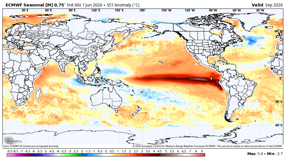
-
2026-2027 Record-breaking El Nino
BlizzardWx replied to Stormchaserchuck1's topic in Weather Forecasting and Discussion
Yeah, that is what my page shows as of the 27th for the daily value. As for how I did it, that's an important point to dwell on for any PDO calculation. It's dependent on the period of record, the exact domain, how much you correct the climate change signal, etc. All of these effect the EOF calculation that defines the weights that can then be used in the actual calculation. None of this is clearly standardized anywhere, which is why different groups get different values. I think that mine and WCS are better than NOAA who does not appear to have detrended the climate change signal properly. -
2026-2027 Record-breaking El Nino
BlizzardWx replied to Stormchaserchuck1's topic in Weather Forecasting and Discussion
My calculation has -1.18 for the PDO, so at least relatively in line with WCS. It's definitely been dropping the last few weeks. But the AMO is looking solidly negative now, so that is new compared to recent history. -
2026-2027 Record-breaking El Nino
BlizzardWx replied to Stormchaserchuck1's topic in Weather Forecasting and Discussion
The last few years we've done that mid summer PDO nosedive. I think that will be an early clue for this winter for what path we are on. If we can avoid driving off the PDO cliff maybe things really are changing. This is definitely what we want to see. After a decade of anomalous warmth its going to take some work to clear that heat out, but we should make a good dent if the WWBs and KWs continue. I hope we can get plenty of recurving typhoons this summer and fall to eat up the warmth further north too. -
2026-2027 Record-breaking El Nino
BlizzardWx replied to Stormchaserchuck1's topic in Weather Forecasting and Discussion
You are right that it should be that way, but my suspicion is that the NOAA numbers are so low because its imbalanced. But yes, I don't know that, just a theory. -
2026-2027 Record-breaking El Nino
BlizzardWx replied to Stormchaserchuck1's topic in Weather Forecasting and Discussion
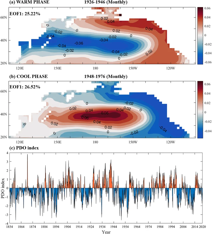
One thing to keep in mind with the PDO is that depending on how you calculate it, it's not necessarily balanced. By that I mean that the main area east of Japan, depending on how you calculate it, can be both larger in area and have a stronger weighting than the half ring around it. This matters, particularly in a warming climate. As warm conditions everywhere can bias the PDO calculation negative for these reasons. In fact I think this already happens with the NOAA calculation. My page and the WCS seem to handle this a bit better but likely not adequately. @bluewavehas talked about how the PDO is becoming less useful with time and this is part of the reason why.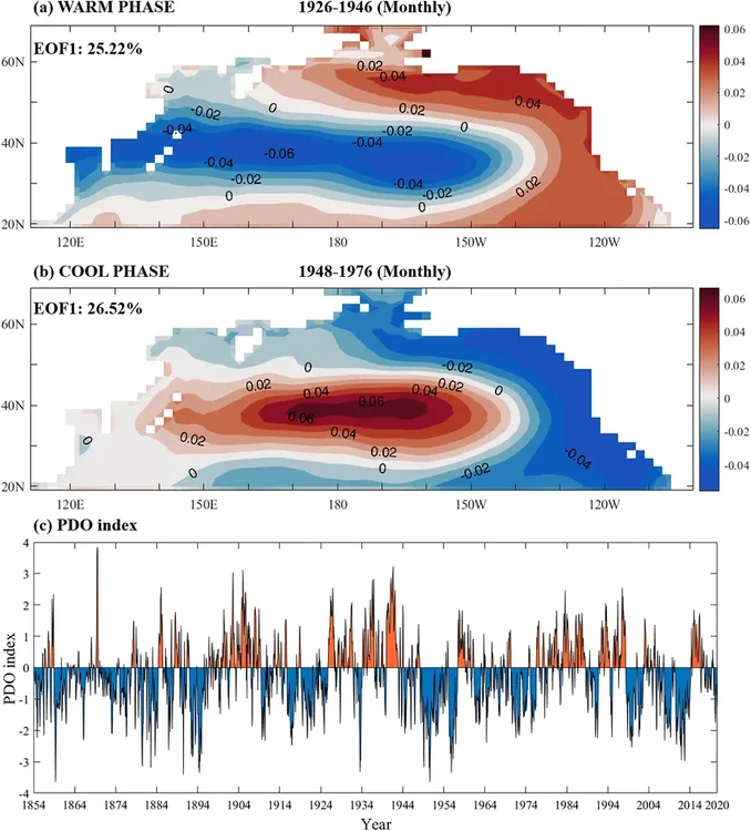
-
2026-2027 Record-breaking El Nino
BlizzardWx replied to Stormchaserchuck1's topic in Weather Forecasting and Discussion
If the west Pacific is able to have a sustained active season, particularly into the fall, frequent typhoon recurves may help to break up the warm water anomalies over there. Perhaps it would help in nudging us towards a +PDO. I guess we will see though. -
2026-2027 Record-breaking El Nino
BlizzardWx replied to Stormchaserchuck1's topic in Weather Forecasting and Discussion
I know for my area we statistically do better with weak to moderate el nino, but if we need a strong nino to finally stir up the west pacific warm pool I will take it. I agree that this does not look like 2023 at this point, but its also real early and it would be silly to be too confident in any outcome yet. -
2026-2027 Record-breaking El Nino
BlizzardWx replied to Stormchaserchuck1's topic in Weather Forecasting and Discussion
If somebody has a data source I can add a plot to my page for this or anything else you want. But I have to assume the -PDO pattern is pretty baked in below the surface still. It'll take time to fix that. -
2026-2027 Record-breaking El Nino
BlizzardWx replied to Stormchaserchuck1's topic in Weather Forecasting and Discussion
By my calculations, PDO is around -0.25 now. So yeah, I'd say we got a chance to finally break this.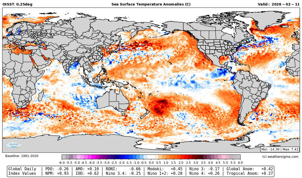
-
And nobody expects perfection! You did a great job this year. I'm really hoping your success keeps going because it would mean we are not done yet.
-
It would take a pretty sharp reversal to get decent cold anomalies in the plains compared to current guidance for Feb. We are going to be roasting at least first third if not first half of the month, like +10 F above normal if not more for my area. Of course January was like that and we still ended below normal because the last third of the month was so cold. But assuming models trend more favorably after any SSW maybe we still have time. I don't think it would take much of an eastward shift in the pattern mid month to turn that western trough into GB/Plains trough.
-
That's fair, but other ensemble guidance is mostly headed that way too. Will it verify? That is another story but in my mind you usually see hints showing up before it happens, so I am at least glad to see it starting to show up.
-
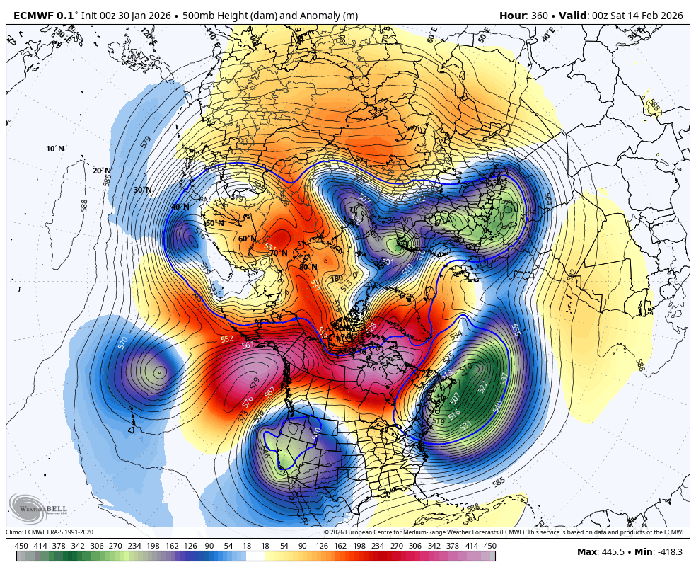
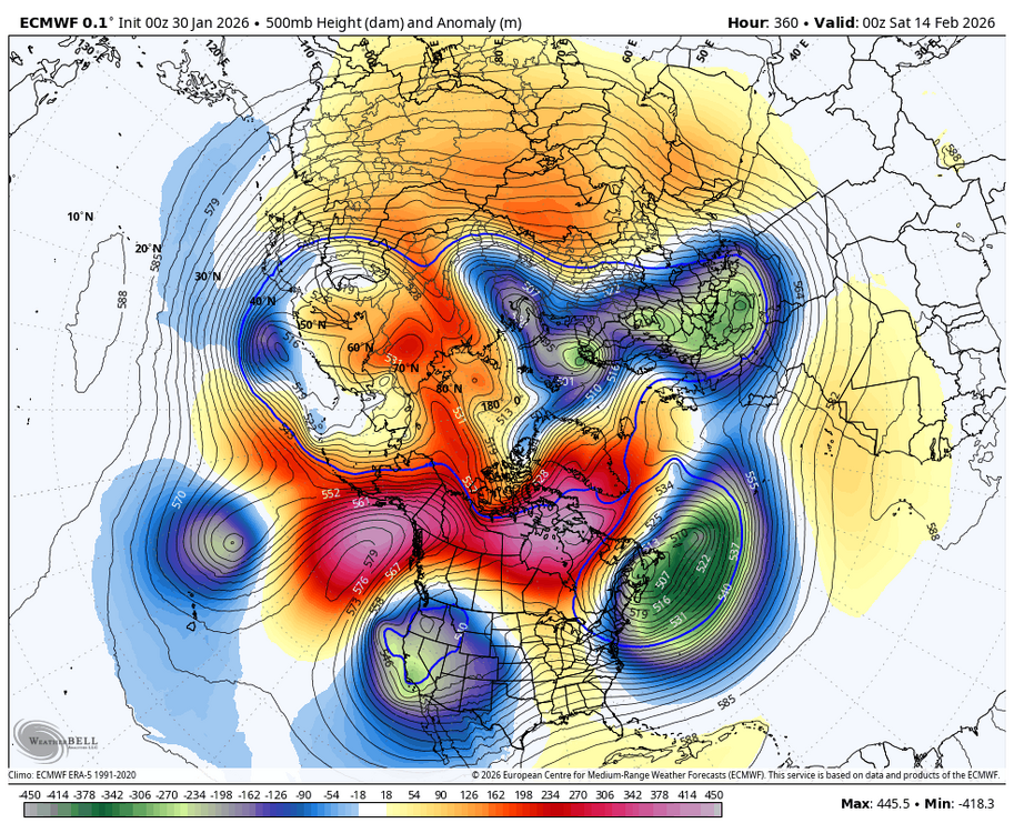
Interesting on some guidance, like last nights ECMWF, how quickly the mid level heights across higher latitudes increase after the PV split. Could be coincidence but I hope we can get this going in February rather than waiting till March to see impacts.
-
Apparently the CPC will start using RONI now in their discussions, just like Australia did last year.
-
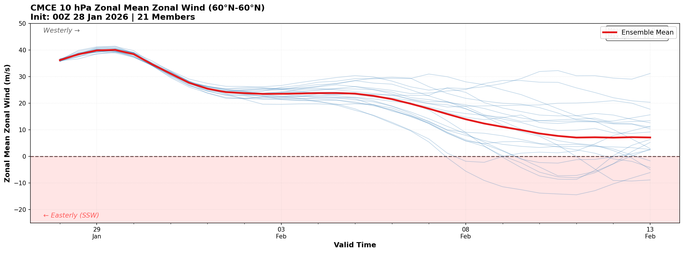
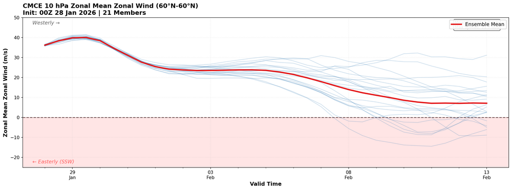
I ran this for last nights CMCE. Starting to see more members showing the SSW.
-
That's an interesting idea because that is basically what you see on the weeklies. It just locks in and stays similar for the rest of Feb and into March.