

SchaumburgStormer
-
Posts
5,206 -
Joined
-
Last visited
Content Type
Profiles
Blogs
Forums
American Weather
Media Demo
Store
Gallery
Posts posted by SchaumburgStormer
-
-
Just now, Stebo said:
I must be missing something here, any shifts to the north this run cycle have been very minor and the HRRR has actually shifted a bit south run to run.
Mostly noise at this point, but understandably, those on the northern periphery have been rejoicing.
-
 1
1
-
 1
1
-
-
FV3 going to ride that NW position until the final curtain call.
-
14 minutes ago, Hoosier said:
Omega, you said?
Northern IL

This is going to be epic.
-
12 minutes ago, ConvectiveIA said:
I don’t know entirely but the future radar prediction tool on the weather channel is coming in looking really north. I have to wonder if that tool uses up to date modeling or how it is generated. But my hopes are up for you and Hawkeye.
-
2
-
 4
4
-
-
2 minutes ago, Malacka11 said:
Don't think I've ever heard of a 4-10 inch spread before. It's lookin up boys
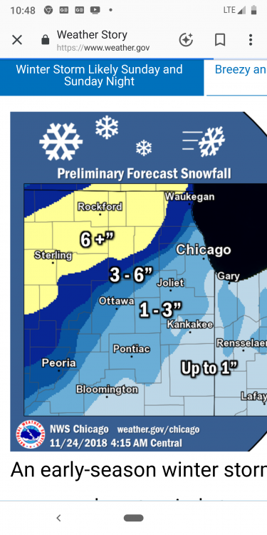
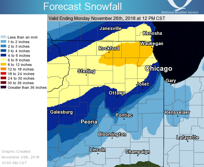
Winter Storm Warning
URGENT - WINTER WEATHER MESSAGE
National Weather Service Chicago IL
144 PM CST Sat Nov 24 2018

ILZ003>005-008-010>012-250345-
/O.UPG.KLOT.WS.A.0004.181125T1200Z-181126T0600Z/
/O.NEW.KLOT.WS.W.0003.181125T1200Z-181126T0600Z/
Winnebago-Boone-McHenry-Ogle-Lee-DeKalb-Kane-
Including the cities of Rockford, Belvidere, Woodstock, Oregon,
Dixon, DeKalb, Aurora, and Elgin
144 PM CST Sat Nov 24 2018

...WINTER STORM WARNING IN EFFECT FROM 6 AM SUNDAY TO MIDNIGHT
CST SUNDAY NIGHT...

* WHAT...Heavy snow expected. Blowing snow possible, especially
  at night. Total snow accumulations of 7 to 10 inches, with
  localized amounts up to 12 inches, are expected.
-
1
-
-
Just now, CoalCityWxMan said:
Honestly concerned about the state roads could be in tomorrow, with lots of people traveling home or back to school it could get real dangerous or even impossible to travel. Even half of what the euro is showing would be bad.
Couple that this will be the first “major” snow of any type for the year. Classic line, don’t travel unless absolutely necessary.
-
3 minutes ago, CoalCityWxMan said:
Still think it’s overdone, but impressive to say the least

22” lollipop in lasalle county.
-
1
-
-
I didn’t see the 6z euro. Was it still amped? 12z running now.
-
2 minutes ago, ChiTownSnow said:
That is the old one.
-
LOT’s entire CWA I-80 north now under a watch
-
1
-
-
2 minutes ago, CoalCityWxMan said:
It’s like a smaller version of the euro, but similar amounts. Looks like a bullseye over Dekalb. You work in Syacmore right?
Indeed, but am off tomorrow. Will be home to enjoy this one.
Which is nice... there are only so many hours I want to spend babysitting “drivers in ditches”
-
1
-
-
-
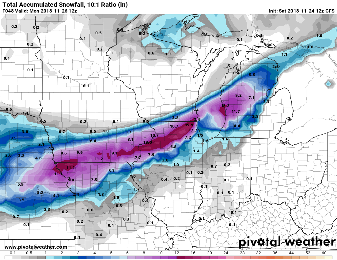
2 minutes ago, ILSNOW said:
GFS thru 42

Ladies and gentlemen, we have a cave.
Monster run for north central LOT.
-
1
-
1
-
-
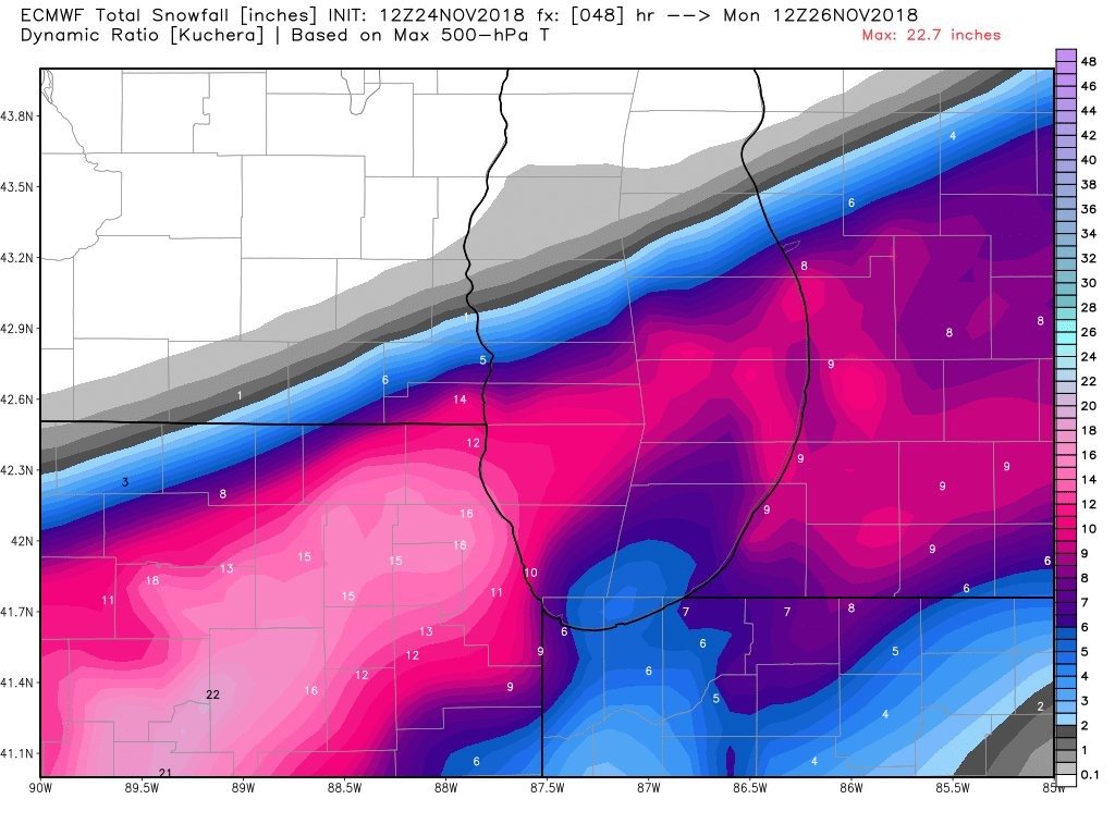
RGEM south, with absolute rip city over central LOT
-
Somewhat insane that we are 30 hours from precip onset, and we still have such a model spread. Real tough for LOT, as the current GFS verbatim is a swing and a miss, NAMs with extreme N and S cutoffs WITHIN the CWA, and the Euro with a historic November blizzard.
I like where I am sitting, but still a bit more nervous/uncertain than I should be this close to the storm.
-
1
-
-
GFS doubles down in the north camp, Euro says “hold my beer”.
-
1
-
3
-
-
10 minutes ago, cyclone77 said:
Don't know why but that made me think of this lol.

Hahaha. Been awhile since I have seen that one.
-
3 minutes ago, ConvectiveIA said:
As I reca the GFS-FV3 was not available until this year, at least not on pivotal. Does this make it a more advanced and higher tech model?
I know it is using the newer tech and running side by side to identify biases, but no idea in terms of verification.
-
Good ole GFS vs everyone battle.
-
-
Wound up tight in NE Missouri at 36
-
1
-
-
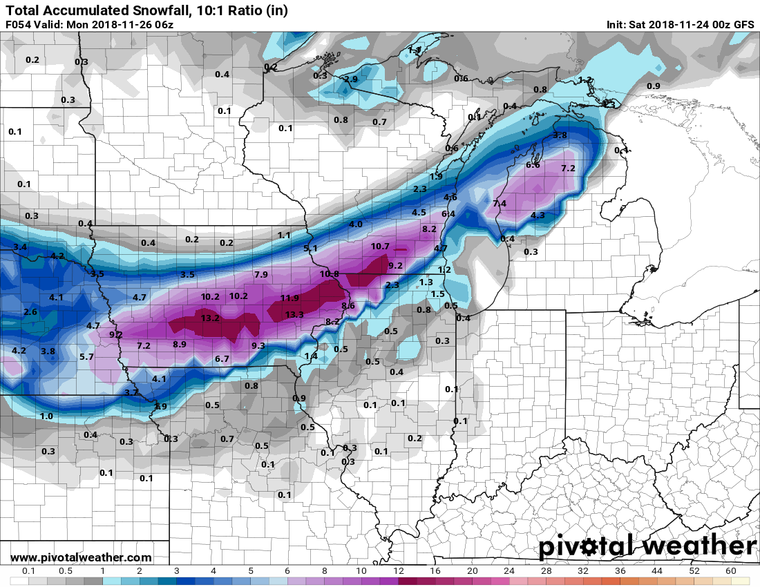
11 minutes ago, Malacka11 said:
00z GFS out an rolling. And so it begins...
It’s gonna be north again
-
Be interesting to see if the GFS sinks back to the consensus or remains the northern outlier.
-
Regardless of track, NAM has been consistent in advertising a rocking death band within the snow shield. Someone is going to see a dumping.
-
1
-


Nov. 25th-26th Midwest Snowstorm Potential
in Lakes/Ohio Valley
Posted
00z GFS holds serve for those hoping for a north shift.