

SchaumburgStormer
-
Posts
5,565 -
Joined
-
Last visited
Content Type
Profiles
Blogs
Forums
American Weather
Media Demo
Store
Gallery
Posts posted by SchaumburgStormer
-
-
21 minutes ago, janetjanet998 said:
you can tell on the Visible there may be some sort of inversion layer in the "warm"sector...so storms may be elevated
.and its late september now....so peak heating over
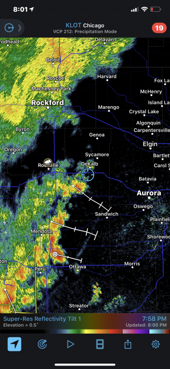
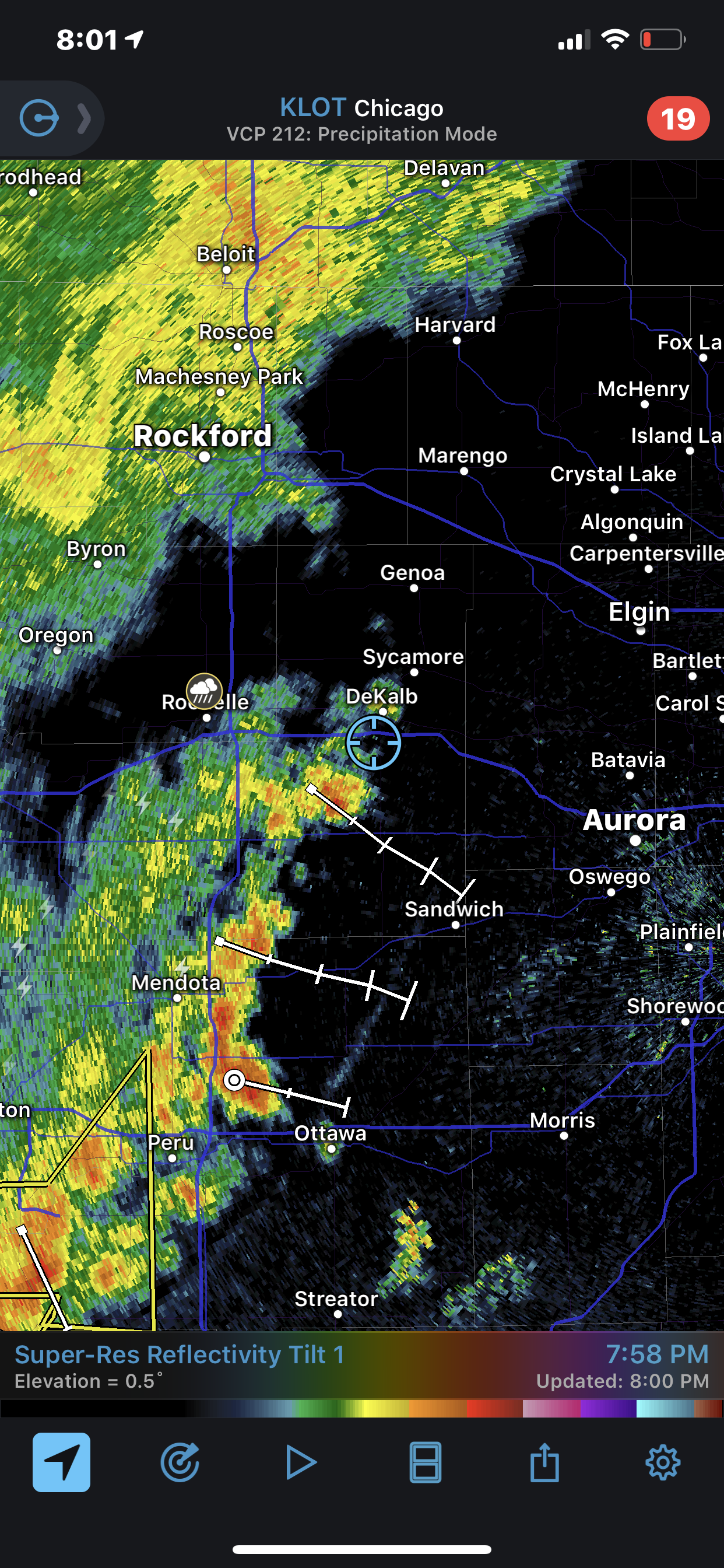
also 5+ inches here in north side of the city so far today
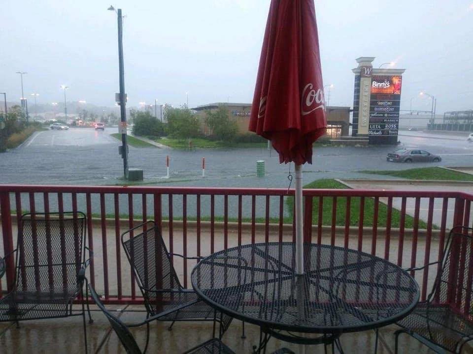
Some wild flooding photos and videos coming out of the Peoria metro.
-
 1
1
-
-
1 hour ago, Indystorm said:
Best parameters are just a smidge sw of him although I presume they will move into his territory as the day progresses. 2500 MLCAPE, 8,5 mid level lapse rates, low LCL's, 3km helicity up to 350. Heck, I'm even wondering if there could be some action down my way later tonight or just north of me across IL and IN. 87/64 here now.
40% EF2+ tornado probs in the watch area.
-
Doing a good job of ducking and weaving around any rain today. .01” in the gauge...
-
Have some siding and tree damage all from the gust front. The storms themselves managed to split around us and just got a T of rain.
-
4 minutes ago, Indystorm said:
Seeing reports of a strong gust front out ahead of precip with these oncoming storms.
Yeah, that’s what gusted me to 58. Haven’t had a drop of rain.
-
13 minutes ago, Indystorm said:
PRELIMINARY LOCAL STORM REPORT
NATIONAL WEATHER SERVICE CHICAGO IL
109 PM CDT SUN JUN 30 2019..TIME... ...EVENT... ...CITY LOCATION... ...LAT.LON...
..DATE... ....MAG.... ..COUNTY LOCATION..ST.. ...SOURCE....
..REMARKS..0100 PM TSTM WND GST ROCKFORD AIRPORT 42.20N 89.10W
06/30/2019 M63 MPH WINNEBAGO IL ASOSGusted to 58mph IMBY
-
23 minutes ago, Indystorm said:
BULLETIN - EAS ACTIVATION REQUESTED
TORNADO WARNING
NATIONAL WEATHER SERVICE LINCOLN IL
647 PM CDT WED JUN 19 2019
THE NATIONAL WEATHER SERVICE IN LINCOLN HAS ISSUED A
* TORNADO WARNING FOR...
NORTHEASTERN CHRISTIAN COUNTY IN CENTRAL ILLINOIS...
NORTHWESTERN SHELBY COUNTY IN CENTRAL ILLINOIS...
SOUTHERN MACON COUNTY IN CENTRAL ILLINOIS...
* UNTIL 730 PM CDT.
* AT 646 PM CDT, A CONFIRMED TORNADO WAS LOCATED OVER MOWEAQUA, OR 13
MILES NORTHEAST OF TAYLORVILLE, MOVING EAST AT 10 MPH.
HAZARD...TORNADO.
SOURCE...WEATHER SPOTTERS CONFIRMED TORNADO.
IMPACT...EXPECT DAMAGE TO MOBILE HOMES, ROOFS, AND VEHICLES.
* THE TORNADO WILL BE NEAR...
MOWEAQUA AROUND 655 PM CDT.Looks like a quick spin up
-
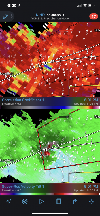
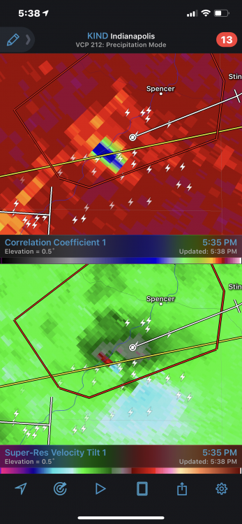
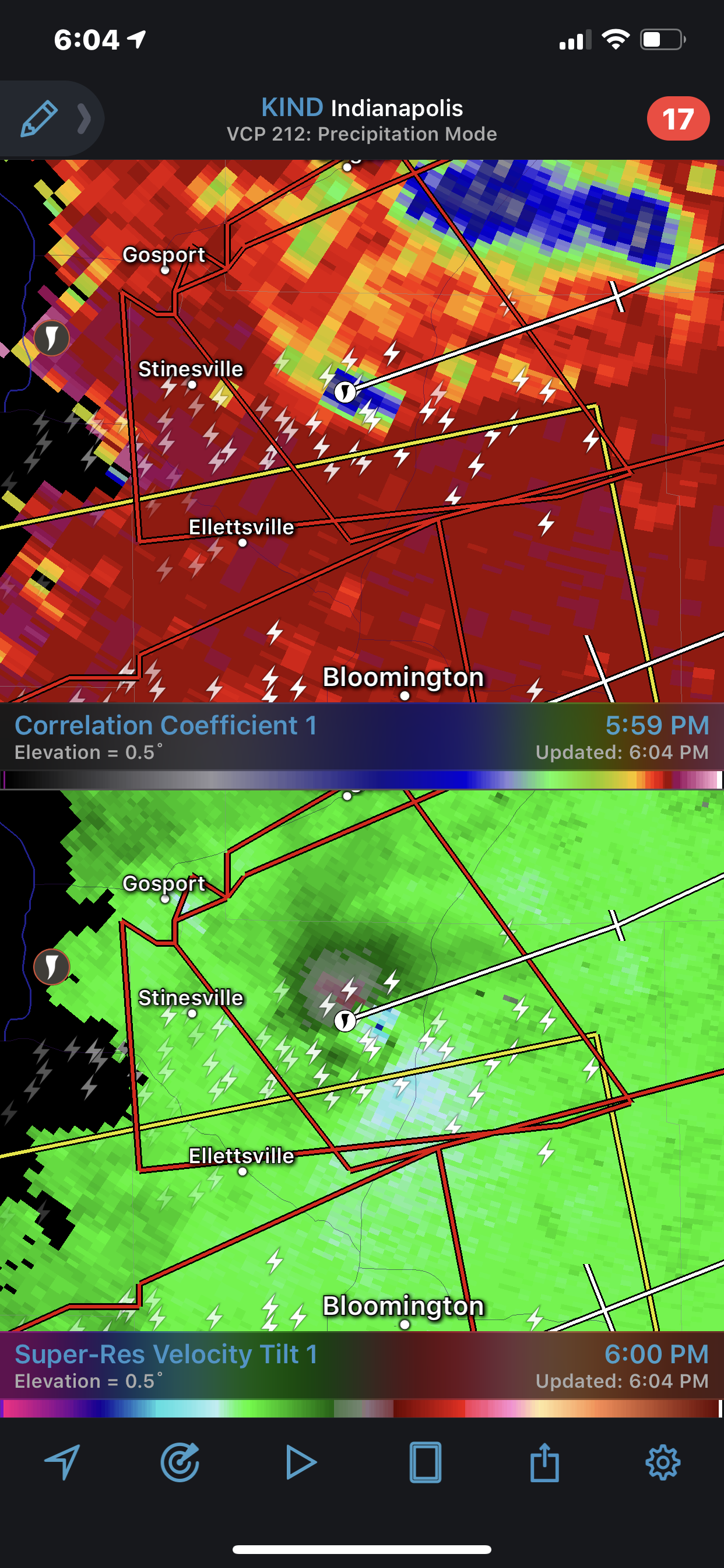
Just now, Indystorm said:
And that is not the cell for which Bloomington proper is presently warned with the cell incoming from the city's west.
That one is now producing as well.
-
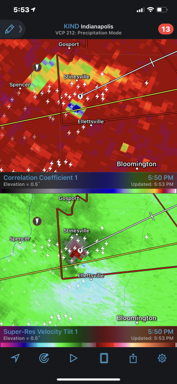
Just now, SchaumburgStormer said:
Based on CC, that one is chewing something up. Big CC drop evident on the past few scans
-
Just now, Indystorm said:
BULLETIN - EAS ACTIVATION REQUESTED
TORNADO WARNING
NATIONAL WEATHER SERVICE INDIANAPOLIS IN
700 PM EDT SAT JUN 15 2019
THE NATIONAL WEATHER SERVICE IN INDIANAPOLIS HAS ISSUED A
* TORNADO WARNING FOR...
NORTHERN MONROE COUNTY IN SOUTH CENTRAL INDIANA...
SOUTHEASTERN MORGAN COUNTY IN CENTRAL INDIANA...
NORTHWESTERN BROWN COUNTY IN SOUTH CENTRAL INDIANA...
* UNTIL 745 PM EDT.
* AT 659 PM EDT, A CONFIRMED TORNADO WAS LOCATED 8 MILES NORTH OF
BLOOMINGTON, MOVING EAST AT 30 MPH.
HAZARD...DAMAGING TORNADO.
SOURCE...WEATHER SPOTTERS CONFIRMED TORNADO.
IMPACT...FLYING DEBRIS WILL BE DANGEROUS TO THOSE CAUGHT WITHOUT
SHELTER. MOBILE HOMES WILL BE DAMAGED OR DESTROYED.
DAMAGE TO ROOFS, WINDOWS, AND VEHICLES WILL OCCUR. TREE
DAMAGE IS LIKELY.
* THE TORNADO WILL BE NEAR...
MAHALASVILLE AROUND 725 PM EDT.
BEANBLOSSOM AROUND 735 PM EDT.
MORGANTOWN AROUND 740 PM EDT.
SPEARSVILLE AROUND 745 PM EDT.Based on CC, that one is chewing something up. Big CC drop evident on the past few scans
-
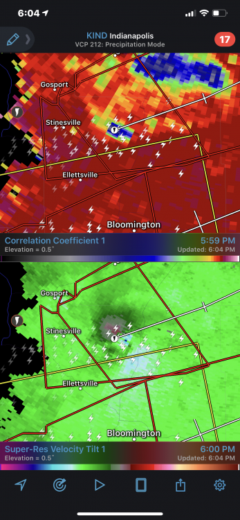
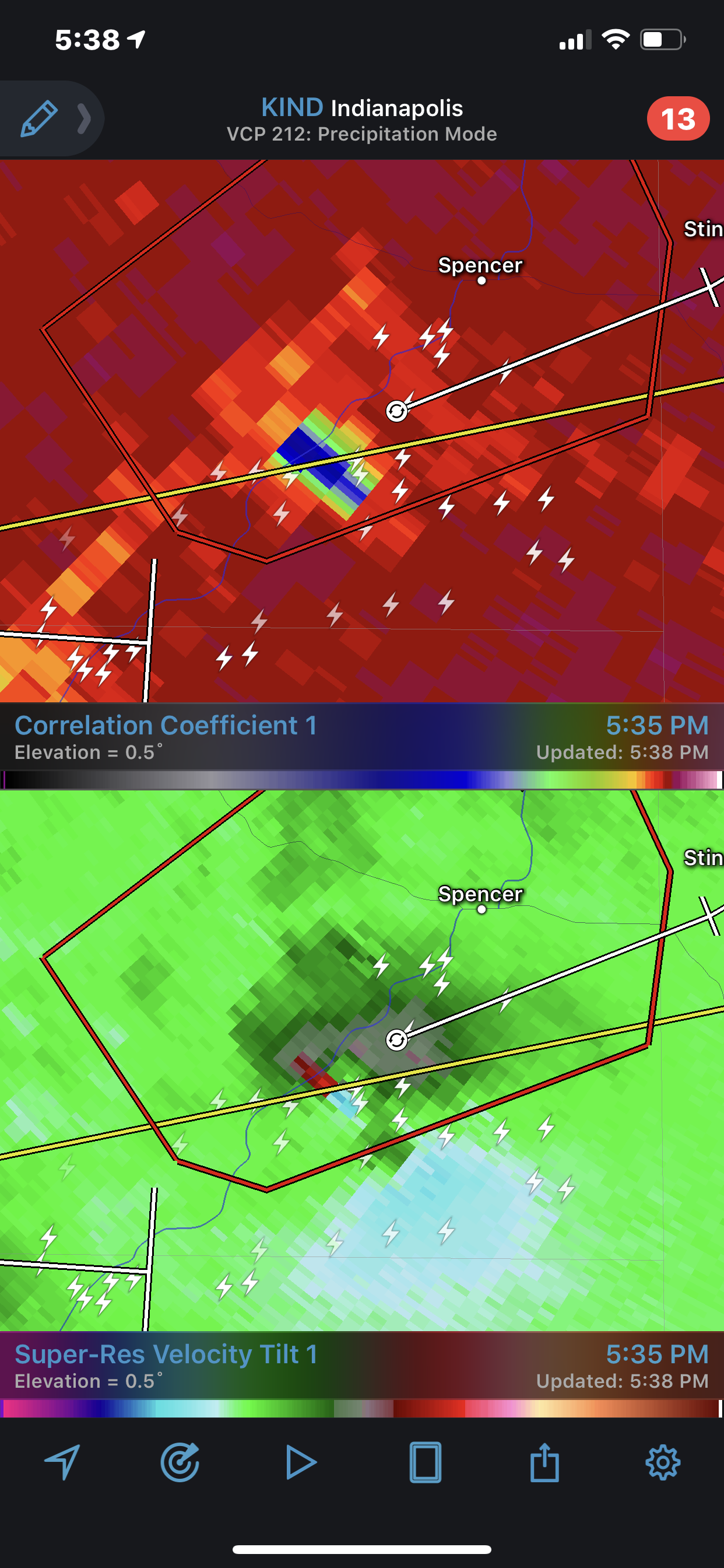
Just now, Indystorm said:
Now tor warned due to rotation west of the area.
It’s tightening up and getting its act together quickly
-
Cell to the south going to make a run towards Bloomington
-
Another big TDS from that new area of rotation
-
Looks like the Indiana storm cycled and threw a new area of rotation SE of the prior one
-
42 minutes ago, Indystorm said:
First tor warning of this episode...
BULLETIN - EAS ACTIVATION REQUESTED
TORNADO WARNING
NATIONAL WEATHER SERVICE INDIANAPOLIS IN
555 PM EDT SAT JUN 15 2019
THE NATIONAL WEATHER SERVICE IN INDIANAPOLIS HAS ISSUED A
* TORNADO WARNING FOR...
CENTRAL SULLIVAN COUNTY IN SOUTHWESTERN INDIANA...
NORTHWESTERN GREENE COUNTY IN SOUTHWESTERN INDIANA...
* UNTIL 630 PM EDT.
* AT 555 PM EDT, A SEVERE THUNDERSTORM CAPABLE OF PRODUCING A TORNADO
WAS LOCATED NEAR PALESTINE, OR 11 MILES EAST OF ROBINSON, MOVING
EAST AT 50 MPH.
HAZARD...TORNADO AND QUARTER SIZE HAIL.
SOURCE...RADAR INDICATED ROTATION.
IMPACT...FLYING DEBRIS WILL BE DANGEROUS TO THOSE CAUGHT WITHOUT
SHELTER. MOBILE HOMES WILL BE DAMAGED OR DESTROYED.
DAMAGE TO ROOFS, WINDOWS, AND VEHICLES WILL OCCUR. TREE
DAMAGE IS LIKELY.
* THIS DANGEROUS STORM WILL BE NEAR...
SULLIVAN AND PAXTON AROUND 605 PM EDT.
DUGGER AROUND 610 PM EDT.
JASONVILLE AND VICKSBURG AROUND 615 PM EDT.
LINTON AROUND 620 PM EDT.
SWITZ CITY AROUND 625 PM EDT.
PRECAUTIONARY/PREPAREDNESS ACTIONS...
TAKE COVER NOW! MOVE TO A BASEMENT OR AN INTERIOR ROOM ON THE LOWEST
FLOOR OF A STURDY BUILDING. AVOID WINDOWS. IF YOU ARE OUTDOORS, IN A
MOBILE HOME, OR IN A VEHICLE, MOVE TO THE CLOSEST SUBSTANTIAL SHELTER
AND PROTECT YOURSELF FROM FLYING DEBRIS.
Big TDS on that one
-
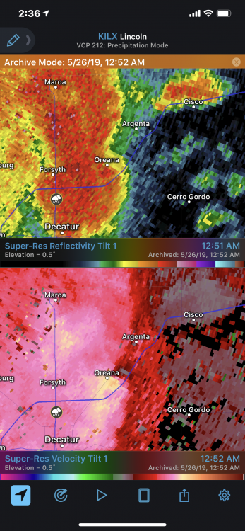
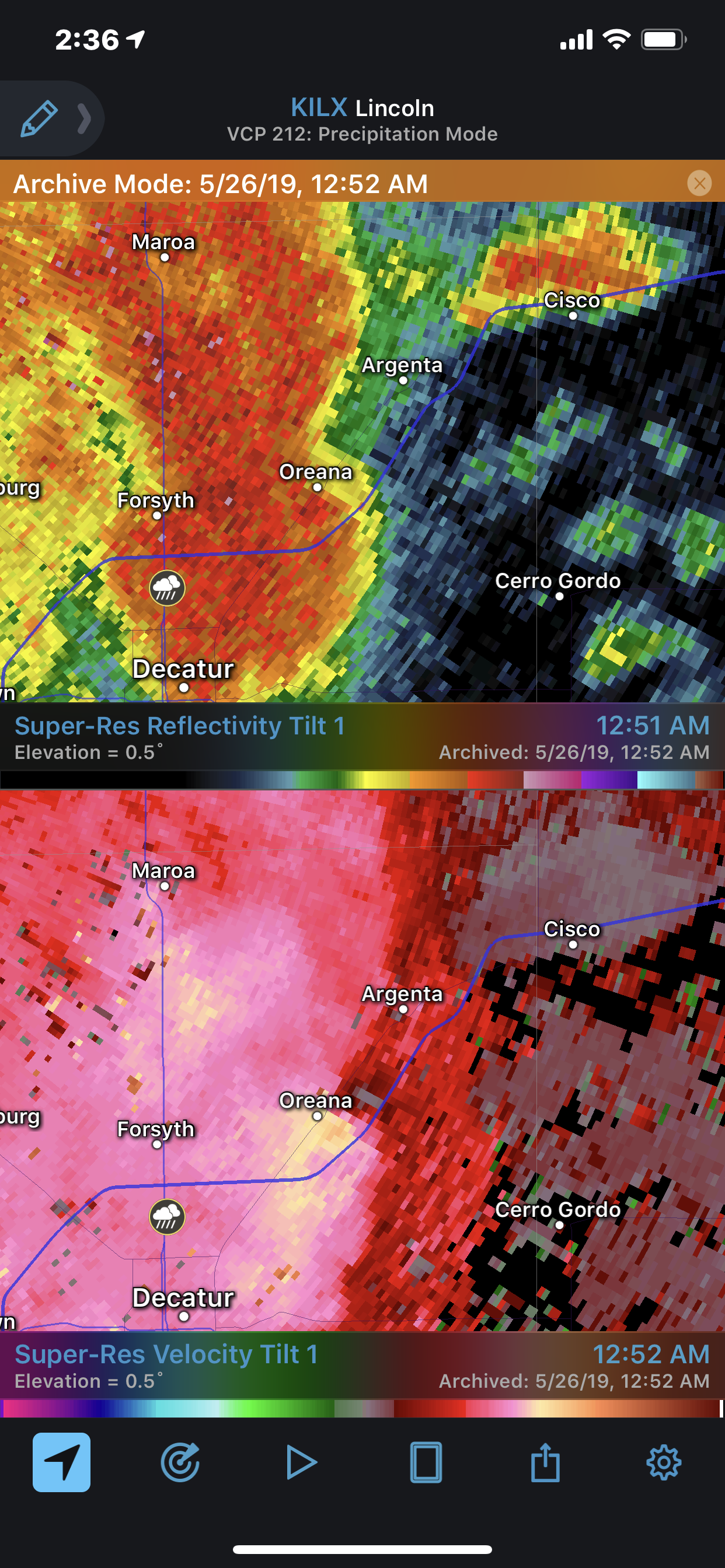
Good amount of damage in the Argenta-Oreana area in Macon county from last night. Luckily my parents had no damage, but quite a bit of large tree damage throughout town. May have spun one up pretty quickly along the line as it passed over Oreana.
-
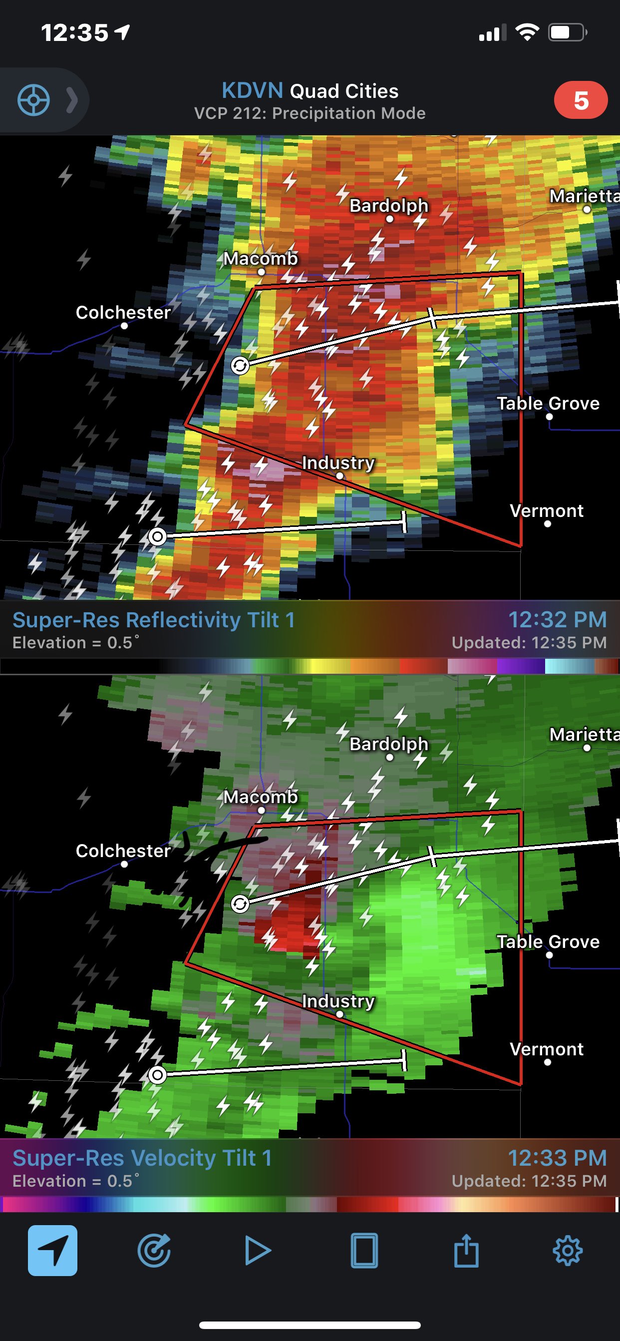
May be cycling. Last grab on velocity didn’t look as good.
-
-
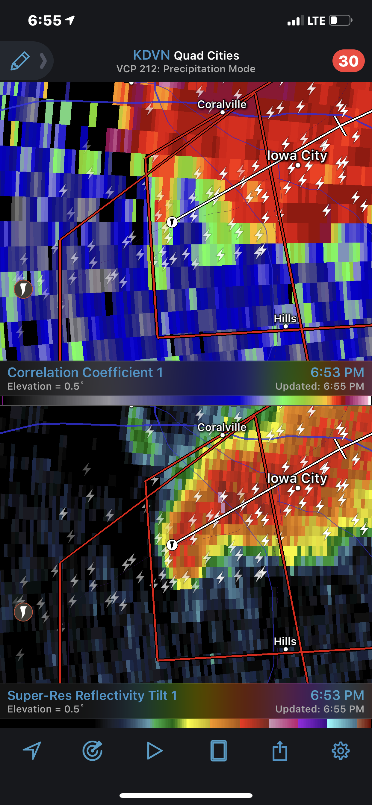
Iowa city is going to have a serious problem if this doesn’t cycle. Still a tight couplet
-
Strong tornado tracking to Iowa city
-
Full sun in RFD
-
1
-
-
1 minute ago, metallica470 said:
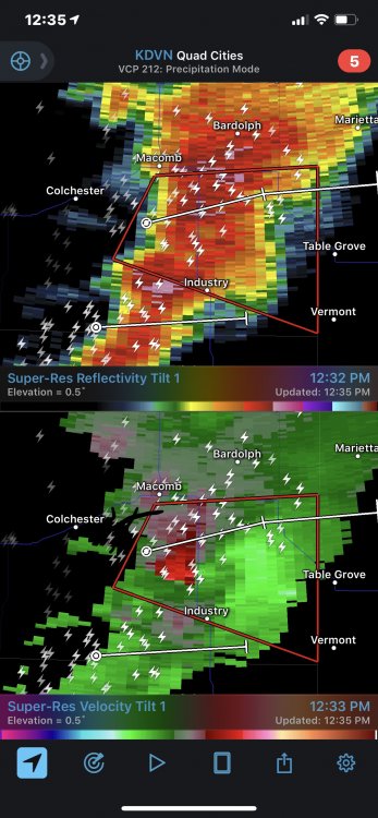
New warning says confirmed tornado over Lewistown
Velocity doesn’t look great at the moment. May be cycling
-
Hopefully this thing stays south of Lewistown. One of the bigger communities in that immediate area
-
Cell near macomb will be heavily rain wrapped if it produces


October 2019 General Discussion
in Lakes/Ohio Valley
Posted
Can confirm, have gotten under 32 both nights. Expect another frost tonight