

SchaumburgStormer
-
Posts
5,221 -
Joined
-
Last visited
Content Type
Profiles
Blogs
Forums
American Weather
Media Demo
Store
Gallery
Posts posted by SchaumburgStormer
-
-
1 minute ago, beavis1729 said:
And the 06z GFS shows -37C in the same area. Pretty amazing. It seems pretty certain that -35C H85 temps or colder will occur in parts of IL. If so, you'd have to think that LOT's forecast lows could be a bit conservative on Wed morning (generally -20 to -23)...but of course it makes sense to go conservative for now, then they can always bring temps down a bit over the next 12-24 hours if the models hold on to this.
Considering MBY and several other areas out this way went to -24 the other night, someone is going to make a run at the deep -30’s
-
WAGONS SOUTH!
@cyclone77 pulling this one in.
-
 3
3
-
-
DVN to UGN path across IL
-
Just now, ChiTownSnow said:
Quite a bit.. looks like a decent hit for Chicago.
Uh yeah. It’s around Cedar Rapids at 21. This should be a smoke job for N il
-
GFS coming south a bit
-
Shame this is going to be an overnight event, should see some excellent rates with things really rocking and rolling for a good portion of the night.
-
33 minutes ago, Chicago Storm said:
12z NAM coming in south yet again.
.3km a bit north, with the low just north of the state line
-
8 minutes ago, cyclone77 said:
New Euro now shows -30 to -33 readings Thu morning over northwest IL/extreme eastern IA. Also only -20 around noon on Wed for the same areas. Very impressive.
EDIT: I should point out the 12z Euro showed 63 degree warmth the following Monday over these same areas. I'd wager my retirement fund anything over 60 is not possible no matter what kind of insane pattern shift took place.
Probably a fair bet. Deep frozen ground, snowpack, and a quick turnaround? No way.
-
1 minute ago, cyclone77 said:


-
 1
1
-
4
-
-
2.4” from today’s clipper
-
1
-
-
4 minutes ago, Hoosier said:
Snow has commenced. Upstream radar looks pretty good.
Those heavier returns are awesome. Turn on the fireplace, crack a beer, and enjoy.
-
13 minutes ago, Sciascia said:
GFS begins to bring the low through the IL/WI border at 42. Slightly south of 12z.
A touch south, baby stepping to get 88 north and the northern burbs to warning criteria
-
3
-
-
Great flake size. Snow globing for sure.
-
Solid 4-6” thump on the 3km NAM.
-
5 minutes ago, Baum said:
Yup. I think many of the Chicago folks are only interested in 10" or greater events these days. Perhaps they should remember December...

Big dogs or bring on golfing weather.
-
2
-
-
Just now, CoalCityWxMan said:
Major changes occurred 12 hours before onset of the last system, nothing is set in stone just yet
Don’t exactly need a “major” change to bring 88 north back into the game.
That being said, not holding my breath for much more than an advisory nusciance event here.
-
 1
1
-
-
What a complete waste of a sweet setup. I may end up with 4-6”, but pales to what could have been.
-
1
-
1
-
-
Things really got out of hand. Dropped to -24, -23 currently
-
Pack er up

-
1
-
1
-
-
13 minutes ago, CoalCityWxMan said:
21z SREF plumes are a touch south of 15z
Snowfall lower on the 21z
-
Just now, Stebo said:
At 69 it almost turns into a squall line of snow


-
1
-
-
Just now, Stebo said:
The bleeding definitely stopped on that run, though the evolution is a bit NAMish.
Definitely some strange surface action happening once it gets out of IA
-
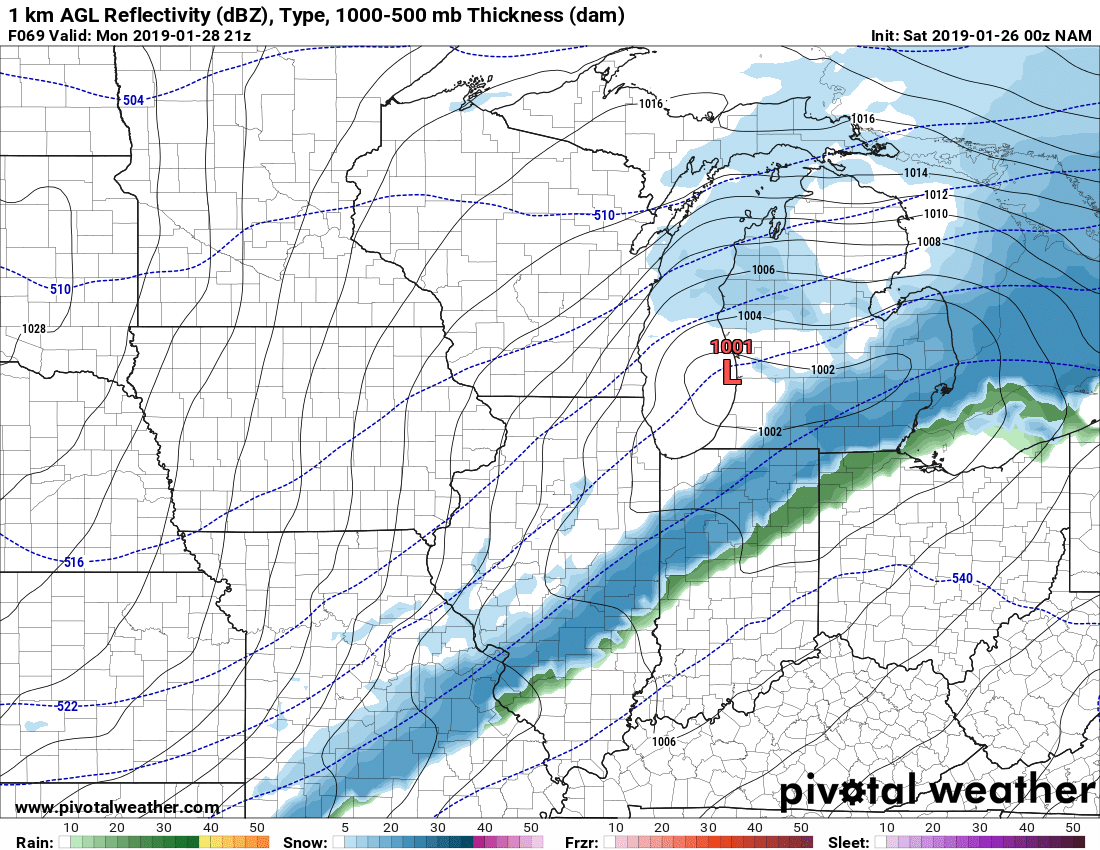
Just now, SchaumburgStormer said:
Definitely south. Over Galena at hr 60
Then rides due east along the state line.
-
13 minutes ago, Chicago Storm said:
The combination of the PV lobe south of the Hudson being further west, plus the wave/storm faster and a bit south likely means this run comes in south overall with the system.
Definitely south. Over Galena at hr 60
Hybrid Clipper Event 1/27-1/29
in Lakes/Ohio Valley
Posted
Thus far, what I have seen is the low is moving slightly NE as it crosses IL