

SchaumburgStormer
-
Posts
5,216 -
Joined
-
Last visited
Content Type
Profiles
Blogs
Forums
American Weather
Media Demo
Store
Gallery
Posts posted by SchaumburgStormer
-
-
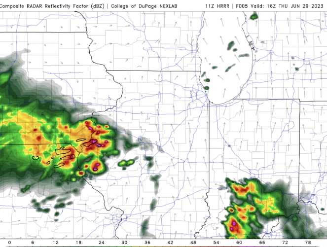
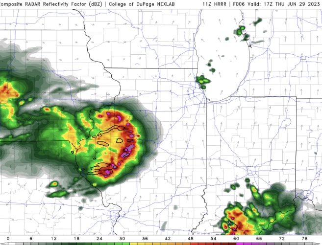
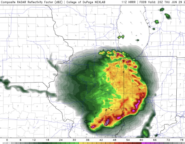
LOT afternoon update is spicy.
Over the next few hours, explosive thunderstorm development appears
likely near the Mississippi River with the favorable thermodynamic
and kinematic parameter space supporting a quick evolution into
several supercells. Damaging winds and hail are likely with any
storm. Perhaps more concerning, Bunker`s right storm motion along
the warm front will provide unusually long residence times within
the high-magnitude low-level SRH environment, supporting an
unusually high threat for episodic strong tornadoes (EF2+) for our
local area
-
 2
2
-
-
SPC going to drop a tor watch across N IL according to the meso discussion. Also added a little pocket of enhanced risk over N IL
-
1
-
-
2 minutes ago, Malacka11 said:
Distant rumbles of thunder here. Heavier returns are blossoming rapidly a county or so upstream so it could end up being a decent soaking here for a while.
Going to be hard for us to split the gap on this one. Going to be a solid soaker.
-
2
-
-
1 hour ago, Chicago916 said:
If the MCS dies quicker, still decent potential for severe in NIL, but looks very conditional. 12Z HRRR for example. Will need to watch incoming CAMs to see if they follow, and observations.
MCS seems to be maintaining well. Probably no dice for any severe in N IL today
-
37 minutes ago, Baum said:
Farewell drought. We hardly knew ye.
Only 1.44" over the past few weeks out here. Still got some pretty deep soil moisture deficits
-
Storms popping behind that lake front.
-
1
-
-
Fucking split the uprights. When it’s not your year, it’s not your year.
-
 1
1
-
-
Hacked a large amount of the slight risk out of the D1 outlook. Only remaining slight in our sub is over the Chi metro.
-
Just got back from Vegas with their 110s+… they can keep it
-
 3
3
-
-
Peoria better keep their head on a swivel with the current track
-
1 hour ago, sbnwx85 said:
The 11z HRRR run tho
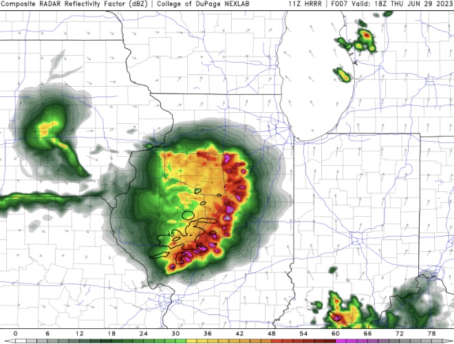
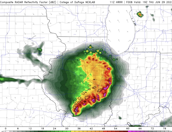
Storms seem to be pushing a bit further NE than depicted by the HRRR
-
1
-
-
12 hours ago, SchaumburgStormer said:
Yep, 90 degree with some ozone and you better shout it from the rooftops. Smoke so thick its blocking the sun? Nah. Leave it to IL government to fuck up something so simple.
13 hours ago, RCNYILWX said:Since that's what the 2nd paragraph of their statement implies, and they apparently only see their role as alerting sensitive groups, I tend to agree. Behind the scenes, there's bureaucratic stuff with IDEM that we've had to sort out, but they've been very proactive in putting out AQAs, just like all the other state EPAs have been in this stretch, with the exception of the IL EPA.
Sent from my SM-G998U using Tapatalk
Just to rehash this slightly… because I am buzzed and annoyed.
What threshold is the IEPA looking for? A large portion of Illinois had the worst air quality on the fucking planet today.
If this isn’t a slam dunk, I don’t know what is.
-
Rocking 244 right now. Short of the house next door burning down, not sure it gets much worse than this.
-
4 hours ago, Chicago916 said:
Looks like the European model was upgraded, including adding a lot of extended ensemble runs. Will be interesting to see how it performs!
Well considering they were all straight dogshit last winter, it cannot be a bad thing.
-
1
-
-
30 minutes ago, RCNYILWX said:
Since that's what the 2nd paragraph of their statement implies, and they apparently only see their role as alerting sensitive groups, I tend to agree. Behind the scenes, there's bureaucratic stuff with IDEM that we've had to sort out, but they've been very proactive in putting out AQAs, just like all the other state EPAs have been in this stretch, with the exception of the IL EPA.
Sent from my SM-G998U using Tapatalk
Yep, 90 degree with some ozone and you better shout it from the rooftops. Smoke so thick its blocking the sun? Nah. Leave it to IL government to fuck up something so simple.
-
3
-
-
That cell near Plymouth looks like its wants to go. Was it the t warned one earlier?
-
Got nearly an inch overnight. Not going to do much for drought improvement, but should keep us from getting worse on the monitor this week
-
-
21 minutes ago, luckyweather said:
N. IL truly has been a rainless paradise. I haven't been watching the temp grids too much but between your reports and Cyclone's reports west of me, I can deduce we've also been in a pretty sweet spot in the gradient here in N. Central IL. The most pleasant spring in my lifetime.
Farmers likely not seeing the beauty in it. This is the slowest start to corn here I've ever seen. Most years the old "knee high by the 4th of July" has been more like "knee high by the 4th of June". Nothing knee high here yet, some late planted fields have barely emerged.
Yep, mid-80s with low dews for weeks on end. Been glorious.
Going to Vegas next week where I should see a stretch of triple digits.
-
2 hours ago, A-L-E-K said:
riding the nam
Been burned riding it at least twice in the last few weeks. Drought gonna dought
-

-
1
-
2
-
-
Another day of mid 80's, mid 50's dews. If its going to be boring, it may as well be pleasant.
-
5
-
-
3 hours ago, A-L-E-K said:
another day, another nightmare euro run
Yeah, starting to look like we may be in big dog drought territory
-
1 hour ago, cyclone77 said:
Looks like widespread mid-upper 90s later next week and beyond. Likely will top 100 here later next week/next weekend. Any rain keeps getting put off till day 10 lol.
49 minutes ago, A-L-E-K said:
lol, what a weird summer
Gradient is sharp. I am caught right in the middle with low 80's each day.


2023 Short/Medium Range Severe Weather Discussion
in Lakes/Ohio Valley
Posted
If something rides the warm front, it could get nasty.