

coastalplainsnowman
-
Posts
699 -
Joined
-
Last visited
Content Type
Profiles
Blogs
Forums
American Weather
Media Demo
Store
Gallery
Posts posted by coastalplainsnowman
-
-
On 9/10/2023 at 3:00 PM, the_other_guy said:
Surprised this isnt up here yet. Due to climate change, a beetle is destroying pine trees in Eastern LI.
The Climate has warmed enough that the bug can now survive.
Pine trees in the south are immune to it, but LI Pine Trees are not.
Honest question - how does a type of tree acquire immunity to a beetle?
-
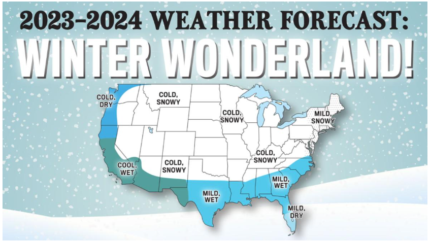
This is from the home page for the *Old* Farmer's Almanac. If I'm being honest, with the Northeast comfortably in the Snowy zone, this map evokes memories of those awesome 'A Look Ahead' maps from The Weather Channel in the 1980s. Memories as strong as childhood memories of the aroma of Mom's Sunday dinner.
-
 1
1
-
 1
1
-
-
On 8/7/2023 at 5:37 PM, WestBabylonWeather said:
I hope this thread is banging during winter time
.During winter time, especially in the run-up to potential major winter storms, the emotional roller coaster which will be the Long Island Weather thread will be a treat. I'm not just a member, I'm also a client.
-
1
-
-
Out of the blue question here.. You now how today a lot of posters despair about climate change being the cause of our recent lack of snow, and fear that our days of snowy winters are numbered? In the late 70s when all the climate talk was about a "new ice age", are there any snow / winter lovers here old enough to remember that, and were really pumped up about the chance of awesome snowy winters for awhile before things really went downhill and the metro area became a permanent block of ice? Because I think that would be right on brand for many, including myself.
-
I'm wondering if, once we get into July, if we were to take the January 2023 average temperature and compare it to the June 2023 average temperature, if the delta would be among the smallest in recorded NYC history. Seems like, with a few exceptions of course, the weather has been calling for the same light coat each morning, all year.
-
1
-
-
Three years ago today: it snowed.
-
Hard to believe that on this day in 2020 our last snow sighting was still 16 days away.
-
Being inside one year now for the April 8th solar eclipse, I'm thinking of looking to book a room someplace in western new york directly in the path. I was wondering if anyone has thoughts on where might be a good town to visit? Trying to find someplace that will have some decent hotels but enough off the beaten path that it won't be jam packed, and also on the southern edge of the track.. Any advice would be much appreciated!
-
7 hours ago, LibertyBell said:
The anniversary of the historic April 1982 blizzard, it would be lovely to see satellite images, weather maps and photos from his historic event!
Awesome childhood memories. Simpler times. This one is a favorite of mine from WABC-TV. I may have even originally been introduced to this clip here years ago.
Edit: Just saw that bluewave had posted the WABC-TV clip earlier in the other thread, so I removed it to reduce clutter here.
Memories of watching this on the couch, thawing out, in for the day, while Mom put our soaked clothes in the dryer while something good was cooking on the stove. And I wonder why I enjoy the snow so much...
-
 1
1
-
-
3 hours ago, Brian5671 said:
Have to with the expanded playoffs. WS goes into Nov. Someday there will be a MINN-DEN WS that has multiple snowouts
Interestingly enough, the Yankees could have probably hosted 81 games at the Stadium this winter with about the same amount of weather related cancellations as they do in a typical season.
-
1
-
-
1 hour ago, bluewave said:
It’s much easier with the small populations they have there. Each country only has about 5-10 million people.
Other arguments about social programs aside for the moment, the other key difference is that, as I understand it, those Nordic populations understand that there's no free lunch. In Denmark, if you make 30% over the average income, about $87,000 here, you're taxed at 55.9%. Plus a 25% consumption tax for everyone - again someone can correct me if I'm wrong on that.
Who's ready to sign up for that here? Here, roughly 58% of Americans pay zero income tax. Yeah, I know, 7.6% Social Security and FICA, and local sales tax, but that's nothing compared to what they pay in the Nordic countries as mentioned above.
If you confiscate every last dime of every US billionaire, you could run the country for a grand total of 8 months. Nevermind the fact there would never be another billionaire to tap ever again.
Allow me to be master of the obvious and state that this isn't sustainable.
-
1 hour ago, LibertyBell said:
and they are food deserts...many of our health conditions, like the diabetes epidemic are worse because of that...we have both urban and rural food deserts where fresh unprocessed food isn't commonly available.
Did somebody say dessert?
-
1
-
-
10 minutes ago, LibertyBell said:
100% concur
99% of people are stupid and need to be controlled....and that includes corporations.
"average" people are stupid too, but are more dangerous because they can do much more harm than a below average person.
But the government is corrupt too and needs to be controlled also-- I'd say by AI, since AI is best equipped to make rational scientific decisions than any human on this planet ever could.
Freedom should not include the right to be ignorant, stupid or corrupt.
Wow.
I have about a hundred problems with the above, but I'll just say this: History says that when governments take the sort of control that you are wishing for here, the very first people who lose their, uh, rights, are the academics, the professors, i.e. not the people you guys would consider 'stupid.' And history says that those very same rounded up people were the ones wishing, right up to the moment they were rounded up, 'Oh, if only we had a strong government to control these stupid masses.'
-
2
-
-
May I make a meta-banter comment/question? One thing that always amazes me on this board is that I often see an account post, don't recognize the handle, and then see that it's made thousands (sometimes tens of thousands) of posts, and has been on the board for years, yet, unless I'm totally losing my marbles, I'm seeing the handle for the first time. I can't figure out how that's possible. Is it just me?
-
5 minutes ago, donsutherland1 said:
There were back-to-back storms on March 16-17 and March 18-19. It was an epic finish to the winter.
Wow, was the 16th-17th a snow event for LI? If so, the record for snowcover depth following that storm must be the all time March record for LI near ISP, if they were keeping records back then, right?
-
8 hours ago, jm1220 said:
I hope we can avoid the back door front parade this year. The utter fail Winter 19-20 featured snow on Cinco de Mayo. If we can get stretches of days in the mid 60s and sunny-perfect.
Actually it was Nueve de Mayo lol.
I'm with you on the mid 60s and sunny, but those seem to be fewer and further between the last 20 years. And those of us on the south shore of LI suffer the longest.
Worst of both worlds. In March we get cold rain while our neighbors to the north and west get fluffy snow. In April we get cold mist while our neighbors to the south and west (and even the north shore of the island) get sunny and blue skies.
-
1 hour ago, LibertyBell said:
I have fond memories of 1993-94 though even on the south shore. That was one case where the mets were usually underdone on snowfall amounts. I remember Mr G did amazingly well with his 10 PM updates on PIX11 because he always said it looked like we were going to get more snow than originally forecast-- AND WE DID!
Absolutely. Best memories of that winter here (and there are plenty)
- Stuck in traffic in an 8" storm on a Tuesday (1994 so a rarity for anyone under 25 at the time), and on the radio talk about the next 8" storm headed here Friday, which of course it did.
- Snowpacked sidestreets the norm for about a two week stretch
- Ice storms which never flipped to rain
It's almost unfathomable now, especially the snowpacked sidestreets part.
Sorry, ventured down Memory Lane a bit there.
-
2
-
1
-
-
2 hours ago, donsutherland1 said:
Periodic extreme forecast update...
The extreme forecast in question called for March 1-April 15 to have an average temperature of 5° below normal with 20" or more snow in New York City. The forecast always had very little chance of ever verifying.
At present, the temperature would need to average 7.5° below normal from March 14-April 15 (40.0° against the 1991-2020 normals). The last time a year had an average temperature of 40.0° or below from March 14-April 15 was in 1956. 13/16 cases with such temperatures occurred prior to 1900.
Through today, it is likely that NYC's snowfall since March 1st will remain stuck at 0.1". That means an additional 19.9" would be needed through April 15th to verify the forecast. Only a single year in NYC's climate record, which extends back to 1869, had 19.9" or more snow from March 14-April 15: 1956 with 23.7".
In sum, the initially steep hill required for the extreme forecast to verify is growing each day into an ever higher mountain.
So you're tellin' me there's a chance!
-
2
-
-
19 hours ago, NorthShoreWx said:
Norlun in early December 1988 was over a foot in parts of central Suffolk, as was April 1982, but I can't think of any others.
Thanks - I think that locally I must have missed out on the Dec 1988 one. From what I've been reading about Norluns here, seems possible that central Suffolk got a foot while my total was less memorable. The internet not yet being a thing, ignorance was bliss for me on that one. Today I'd be yelling at the radar. Likewise the April 82 blizzard was great but likewise I think was like 8-10 here, but that's from memory/TV at the time.
-
1
-
-
1 hour ago, MJO812 said:
Just end this awful winter
Another period this month where people got suckered into a favorable pattern and nothing to show.
I'm borrowing heavily from a well known quote here:
Snowless decades create patient snowlovers
Patient snowlovers are rewarded with snowy decades
Snowy decades create impatient snowlovers
Impatient snowlovers are punished with snowless decades-
2
-
-
36 minutes ago, EastonSN+ said:
Completely agree. Also, 96/97 through 01/02 where a carbon copy of this year back to 18/19.
Only members who remember the 1960s would have lost their minds like those who just remember this century LOl
Absolutely. I remember doing a rough count once, and during that same timeframe of about 1979-1993, my area of LI had fewer than six storms of 10" or greater, with the Blizzard of '83 being the only one surpassing a foot.
-
2
-
2
-
-
41 minutes ago, Nibor said:
I think it's marginal events where the GFS doesn't recognize eastern LI being land and pumps out weird gradients like this one.
A cutoff like that would be the closest thing to Dec 30 2000 that I can remember. I know nothing about the other features of the two systems, but from a snow map standpoint it would be fairly close (though Dec 30 2000 had closer to 10" in Nassau. Still the heaviest two hour period of snow I've ever seen.)
-
1
-
-
1 hour ago, mappy said:
Hi, it does it for me too, I just say continue with safari and it goes away. You don’t have to have taptalk.
Thanks - that's what's weird though - unlike other websites which prompt me to use either some specific app *or* Safari, this site only gives me the 'option' of Tapatalk..
-
I noticed in the last year or so that when I bring up americanwx.com from my phone, that it sometimes insists that I use 'Tapatalk' instead of my browser. It will still let me browse, but everything is dimmed. Usually prompts like this will still have the phone browser as an option for those who prefer it, but seems no such luck in this case. Any idea? Or do I have to give in and get Tapatalk? I reluctantly decided to proceed to install it this week, but given that the prompts during setup made it seem like it's primarily a tool to mine me for information, I declined.
Another big Sept rain event between roughly midnight Friday morning and midnight Sunday morning (bulk 9/29-30/2023)
in New York City Metro
Posted
Taking this at face value, Massapequa Park seeing nearly 2" less than North Massapequa (4.73 to 2.79) is quite the dropoff.