
H2Otown_WX
-
Posts
3,144 -
Joined
-
Last visited
Content Type
Profiles
Blogs
Forums
American Weather
Media Demo
Store
Gallery
Posts posted by H2Otown_WX
-
-
6.1" depth/6.4" storm total at BDL. 2.1" as sleet. Impressive. Just wanted to say a great storm for ALB. That place has been a snowhole in recent years so it's nice to see them get a good event. Their depth is 13".
-
 2
2
-
-
3.1" new here at BDL. 1.3" last hour.
-
3 minutes ago, RUNNAWAYICEBERG said:
And considering it warms us to plain rain, the amounts are actually higher.
Get those genny's out. I wish I had one lol. I'll be at BDL for this though, working a double shift.
-
53 minutes ago, RUNNAWAYICEBERG said:
You further south than me but I highly doubt you or I get a above freezing.

-
 1
1
-
-
2 minutes ago, Lava Rock said:
Twc should be ashamed of themselves
Sent from my Pixel 2 using Tapatalk
Yeah I was thinking the same. That's embarrassing for a first call map. I guess they're dying for east coast ratings since we've had squat south of BOS.
-
2 minutes ago, ORH_wxman said:
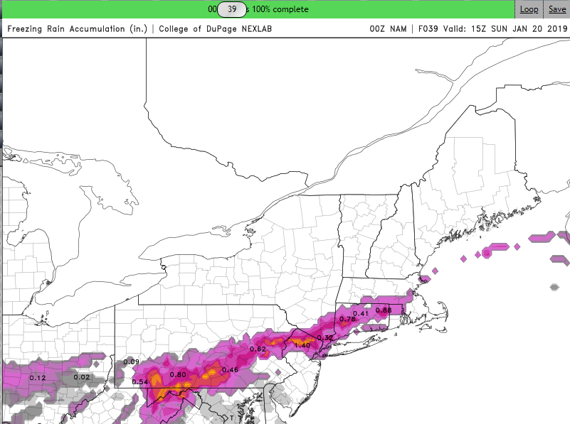
You have a fresh arctic dewpoint feed that will offset latent heat in this case....that's what happened in ORH in Dec 2008 despite extreme heavy rates at marginal 30-31F temps. The dewpoint feed offset it and kept accretion from slowing down too much.
The heavy rates themselves will cause a lot of runoff, so you'll lose some QPF to that, but you would still get exceptional icing with that setup.
Okay, that makes sense. I remember seeing the icing on the trees in December '08 when I went up to the Worcester area for a basketball tournament. I couldn't believe how bad it was. I really hope you're right that thisends up being more a snow/sleet scenario. Would you guess that even though the Euro is picking up on the valley CAD, it's underdone? As in sfc temps. will probably be lower than it's showing?
-
3 minutes ago, ORH_wxman said:
There's still a big part of me that thinks a lot more sleet (and snow) than ice given the type of airmass we are dealing with and I think models may show that as we get closer....but if we keep the shortwave fairly amplified, then icing def becomes a big concern and it could be pretty bad in a swath where the big big QPF is butting up against that intense CAD at the sfc.
I thought high rates would cause too much latent heat release and minimize accretion? Looks like heavy rates on the Euro anyway.
-
26 minutes ago, CT Rain said:
Yeah that looks to me like mid 20s at BDL and 50s for GON lol
Yikes, I'm observing Saturday night at BDL. If you see mistakes you can blame them on me. Maybe I'll get stranded there?
-
Just now, ORH_wxman said:
LOL what is it doing at 150. Redeveloping low to south.
Garbage in, garbage out?
-
50 minutes ago, codfishsnowman said:
boy that's tasty but I have never seen a distribution like that ever...lolol at the gradient from the coast to a few miles inland
http://www.raymondcmartinjr.com/weather/2001/05-Feb-01.html
Not as drastic as the CMC but I see some similarity.
-
1
-
-
It'd be nice if they put the BDL snowfall page back too. It had a table of monthly snowfall data going back to the early 1900s.
-
4 minutes ago, 40/70 Benchmark said:
Stronger and more east based el nino events have more huggers...like 2006,2002 and 1986.
Hmm, interesting. 06-07 was a waste though. I was playing baseball with it 70F in January and it didn't snow until the 2nd week of February. I know it was a huge second half north of here.
-
Just now, ORH_wxman said:
I would say latitude is a lot more important in Niñas.
Yeah that makes sense. I'm just trying to figure out which ENSO state would actually favor west of the river. Maybe none of them lol. Also, we've had big coastals in Ninas lately so it seems the latitudinal rule isn't so applicable this decade.
-
32 minutes ago, 40/70 Benchmark said:
Yes. It doesn't have to mean that western zones get screwed like 2015...but eastern areas should have better anomalies.
So eastern areas jackpot in fast flow Ninas and blocky slow flow Ninos?
-
19 minutes ago, The 4 Seasons said:
Anyone with final totals in CT PM me or tag me and ill try to get a map at ASAP.
9.3" including the sleet.
-
8.5", just turned to IP.
-
1 minute ago, WinterWolf said:
How bout west central areas??
h5 tracks basically overhead. No bueno.
-
Just now, Connecticut Appleman said:
I think you are still going to beat me (even with the change in location) - closing in on 3 inches.
Weren't you in Ellington? With all the Miller Bs we've had the last decade or so I'd say that's the better place to be.

-
7.6" here.

-
7 minutes ago, RUNNAWAYICEBERG said:
Nice man. 8” is achievable.
Agreed. I figured out the trees obstruct my snowboard. I only had 3.75" on it. But on the deck in the back and chair on the side I had 4.6" or maybe even 4.8". It sucks I have no good place to put the board. Might as well just use the deck.
-
4.6" down here. Ripping.
-
21 minutes ago, The 4 Seasons said:
What sites are hosting the 6z/18z Euro runs? I don't see anything on wxbell.
I think it's on Ryan Maue's page Dylan: https://weathermodels.com/
-
31 minutes ago, wxsniss said:
Good to be back fellas...
0z Euro with a heavier WAA thump... everything moves in a bit earlier, 850s slightly warmer in pike region, but almost 0.5" more qpf 0z-6z Friday... supports 3k NAM / RGEM at least in intensity of the thump...
I can't see Euro cross-sections but judging from 850s looks like still uncertain soundings approaching 6z near pike... still, with greater intensity of that initial thump as depicted, the NWS 2-3" is looking like a very reasonable starting point and, if things hold, will have to be increased outside 128
Yeah everything is a few hours faster which helps. It brings in precip to SW CT around 11AM. Definitely looks like a shot at warning criteria even south of the Pike if it were to play out that way. Really dumps for about 5-6 hours before it gets too warm aloft.
-
2 hours ago, ice1972 said:
Backlash snows never work out.....no?
The only time I can remember them working out was in February 2015.
Super, Duper SWFE
in New England
Posted
About how much accretion? 0.5"?