
DopplerWx
-
Posts
3,398 -
Joined
-
Last visited
Content Type
Profiles
Blogs
Forums
American Weather
Media Demo
Store
Gallery
Posts posted by DopplerWx
-
-
we need to remember for future storms that the nw trend only happens if it screws you with temps. otherwise you can bank on being dry.
-
 1
1
-
 2
2
-
-
hrrr gives rdu ZERO precip. good lord.
-
CR what time are you planning on reviving the "what did we learn" thread?
-
hrrr has shifted precip east each of the past 4 runs, very similar to the new nam. uh oh...
-
5 minutes ago, Cold Rain said:
It’s unbelievable really...how difficult it is to get legit snow here.
970 mb low off Wilmington and still bone dry, laughable really. We learned last year to never trust the models until you see snow falling from the sky
-
 1
1
-
-
I've seen this movie plenty of times. Gonna be a epic storm offshore with a brutal cutoff and minimal precip back to 95. Friggin Florida with more snow than clt and rdu.
-
1
-
-
if you want snow just have me move away from your town. used to live in charleston, now theyre getting 2-4". moved from raleigh, now they will see some snow. meanwhile charlotte is bone dry.
-
 1
1
-
-
1 minute ago, JoshM said:
I did, me me me

because you did that we will have a jan 2000 redux and you will go down in infamy lol
-
1 hour ago, JoshM said:
0z NAM might toss some of us a bone, if it keeps the trend up.
If I deleted a New Years Thread, and we all get hammered somehow NYD, I think I shall cliff dive off my second story roof.
who was it that deleted it?
-
nam is giving chest compressions for the nyd event, ill toss a rope for those who jumped off the cliff.
-
1
-
1
-
-
glad i saw my 5" of snow a few weeks ago in nyc, makes it a lot easier to watch these storm threats disappear.
-
another inch or so on the back end for western nc and ga, what a great storm for you guys.

-
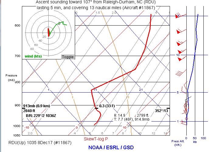
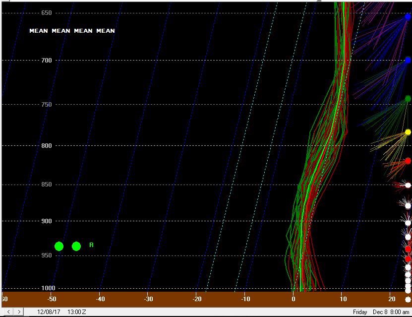
also this should scare you if you have visions of clown maps dancing in your head, models may be underdoing the warm nose (imagine that)
RDU flight observed sounding vs SREF from last night. Notice shallow warm layer from 900-1000mb and the tiny warm nose just before 800mb. It’s as if it was trying to tell us something!
-
warm nose right now looks very similar to the hires nam and hrrr from last night. when you have both of them showing the snow line above you it is usually the kiss of death.

-
i understand being wary of the hrrr but to think it is going to be THIS off? not likely. this is one of those warning shots the day before a storm that you ignore at your own peril.

-
1 minute ago, burrel2 said:
Hrrr has a warm bias. Check out it's 7am run today for the San Antonio area... Notice no hint of snow falling anywhere in that region.
the HP is sitting in the midwest, much different than here. hrrr does not have a warm bias that i have seen, has nailed MANY rain/snow lines over the past few winters.
-
2
-
-
1 minute ago, NCSNOW said:
It's the hrrr v/s every other shortrange model . Cage match, will we have a new champion and unseat the undisput ed short range model champion of the world "per pack"?
Stay Tuned
**every other short range model's snow maps with 10:1 ratios
-
hrrr tomorrow afternoon, no snow to be found in ga, sc or much of nc.

-
newest hrrr has a steady cold rain tomorrow for all of sc and nc outside of the mountains at noon.
-
remember when the hrrr was showing it ripping fatties tomorrow morning in nc? here's the latest run.

-
hires nam showing the snow line not as far south and east as the 12km nam, FYI.
-
1 minute ago, Poimen said:
The 18Z GFS showed rain tomorrow with an expanding precip shield to the NW, then gradually changing to snow from west to east overnight and Saturday. That's probably the best scenario at this point. I wouldn't expect much in the way of snow tomorrow in NC outside of the mountains.
agreed. as the low cranks offshore the precip should end as light snow showers for most. that is a good start to winter in my book.
-
2
-
-
you can't be too surprised if it does trend warmer and most see cold rain, the setup was marginal at best for nc, many just got overexcited by 10:1 ratio snow maps.
-
5 minutes ago, BornAgain13 said:
Thats a valid point, but curious as to why it's doing that.
because we are getting closer to the event and we are at the max range of the hrrr. if it keeps trending warmer everyone hoping for the clown maps to verify better temper their expectations quickly. have seen this song and dance many times.
Southeast Sanitarium - A Place to Vent
in Southeastern States
Posted
after rdu gets 4" tonight i will be the only one in the sanitarium. bummer.