
DopplerWx
-
Posts
3,398 -
Joined
-
Last visited
Content Type
Profiles
Blogs
Forums
American Weather
Media Demo
Store
Gallery
Posts posted by DopplerWx
-
-
2 minutes ago, kvegas-wx said:
Atlantic Beach Pier is about to go down. The waves are knocking the end of the pier sideways. Wont be long.
got a link?
EDIT: nevermind, found it https://www.surfline.com/surf-report/oceanana-pier/584204204e65fad6a7709992
-
3k nam just offshore wilmington at 15hr. shows the core really tightening up as it approached the coast.
-
euro and gfs not far off, euro just a bit more offshore but both take very similar paths.
-
3 minutes ago, BK Rambler said:
Tweet from Joe Bastardi a short while ago:
"new daily update is on, not behind paywall scroll down, No change to 1 week idea up till Cape Fear but after that Have made a change to end game. Lets see if its the only one Believe the new ridge will force this southwest and euro will win"
Joe Bastardi (@BigJoeBastardi) September 12, 2018
of course joe had to put the loop with a possible emergence off the northeast coast lol.
-
1 minute ago, GunBlade said:
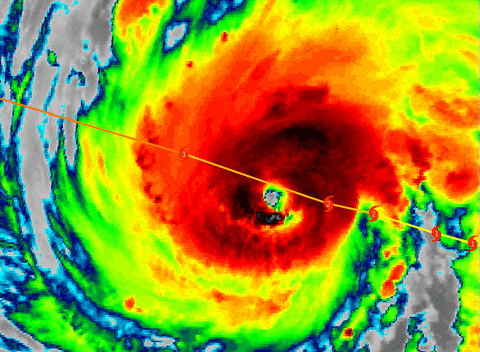
I imagine some strengthening today as it looks to have overcome that small area of shear and is looking much more organized with a good eyewall and has some big thunderstorms expanding north and west of the eyeball even further out now.
agree, western eyewall looks really good now, recon about to head thru it too, lets see how the winds have responded.
https://weather.us/satellite/692-w-301-n/top-alert-superhd-1min/20180912-1243z.html
-
when is recon going back in? haven't had a flight since this morning?
-
ended up a tick slower than the 12z gfs but pretty close to the same landfall location.
-
2 minutes ago, downeastnc said:
Euro a good bit east at 48......
identical to the gfs at 48
EDIT: now it is a bit further east at 54.
-
yep gfs south and west thru 36 as well.
-
1 minute ago, downeastnc said:
The storm needs to come to the Euro then cause so far the track is north of all the recent Euro runs and the Euro is performing worse than most the others....so far...also the storm appears to be moving more NW than anything right now though its tough to tell with the ugly eye but i imagine the separation to the Euro runs is just getting bigger...the FV3 has been very consistent its landfall point hasnt moved more than 10-20 miles run to run for the last 6-8 runs at least.....GFS doing very well so far with track verification...surprisingly enough....still gotta take the blend of the two and thats about where the NHC has it.....the models are doing a bit of back and forth the last day and that probably will continue but overall ILM to MHX is where this likely ends up....
great post, thanks for the verification maps. looks like it will all come down to that turn and how far the ridge stretches.
-
fv3 has shifted sw significantly the past 3 runs, comings towards the EPS solutions of a myrtle landfall. i think we see the eps score a coup here as models continue to converge on myrtle over the next 72hrs.
-
 2
2
-
-
21 minutes ago, StormyClearweather said:
EPS, FWIW:
that is yesterday's run
-
1
-
-
gfs pretty far east this run, wtf?
-
posted in main thread but it is south of nhc track.
-
5
-
-
if im on the sc coast the 00z EPS would reinforce the fact that preparation is vital. the nhc cone is there for a reason.
-
8 minutes ago, Wow said:
Still have a hunch this will end up a SC hit. I think the N turn will be delayed.
yep, like irma's guidance just farther north.
-
gfs comes in sw and slows it down again. have to think it may still be a bit too far N but it moves towards the euro for sure. big to see as it has been an obx landfall the last 6-7 runs or so.
-
this is what concerned me, models shifting south as we close in. luckily the gfs still shows an offshore stall but the euro ensembles all being at the nc/sc border and some further south is worrisome.
-
Pretty concerned that we may see a shift west inside 72 hrs like we did with Irma, except this time it wouldn’t be good for SC.
-
looks like a sc landfall incoming on the euro. right over the gulf stream too.
-
pretty concerning as i wouldn't be shocked to see the ridge even stronger than modeled. recurvature sure seems less and less likely at this point.
also, with the expected forward speed over the warm gulf stream as it approaches the coast, would not be surprised to see minimal weakening prior to any possible landfall.
-
great song!
-
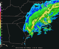
Radar is so typical for a rdu snow, shouldn't even be that surprised.
-
2 minutes ago, Tar Heel Snow said:
oh don't you worry. raleigh never fails at failing at snow.
i moved away so rdu will jackpot. snow curse has been lifted.
-
 1
1
-
Hurricane Florence
in Southeastern States
Posted
center tightening up and convection firing around the center now that she is over the gulf stream, several models showed strengthening as it approached the coast and took the left turn.
https://www.tropicaltidbits.com/sat/satlooper.php?region=06L&product=ir