
DopplerWx
-
Posts
3,398 -
Joined
-
Last visited
Content Type
Profiles
Blogs
Forums
American Weather
Media Demo
Store
Gallery
Posts posted by DopplerWx
-
-
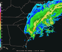
yea this isnt good for clt to rdu. lp inland and this will be a cold rain.

-
 1
1
-
-
encouraging to see the icon bring the snow line south finally.
-
1 minute ago, CentralNC said:
good find, yeah that's probably about right.
-
4 minutes ago, Queencitywx said:
I would generally agree with you but we have two ensemble model suites screaming about this.
i know but i remember in jan 2017 every single ensemble member showed 12"+ for rdu, and i was thinking that there was no way they would all be wrong on temps. and they all were and we got a sleetfest.
-
1 minute ago, olafminesaw said:
It's not surprising it's trended warmer, being early December, all frozen events are extremely rare
yep, climo says no and we are dealing with marginal cold at best. anyone outside of the mountains that has their hopes up needs to save themselves a lot of heartbreak and expect rain. any snow falling before christmas is a win. these clown maps are ridiculous and they give people the expectation of monster totals, when in reality even an inch of snow in early december would be amazing.
-
 2
2
-
-
for our decent storms the warm nose doesn't bring us back down to reality until 48-72hrs out, so to see this so early is not good. mountains and foothills are understandably excited but if anyone thinks CLT and RDU aren't in for a classic screwjob you're mistaken. That 2017 snow/ice map is probably going to be close to reality for this event.
-
3
-
-
rain snow line is just north of clt it looks like at 120
-
4 minutes ago, Poimen said:
I’m always leary of questioning Dr. No, but is this a classic case of the model underestimating the depth of cold/CAD airmass at this range, or is that just my inner weenie talking?
gotta be careful to not let your weenie out.
-
3
-
 5
5
-
-
a little better than i first thought for CLT on the 12z gfs.

-
 1
1
-
-
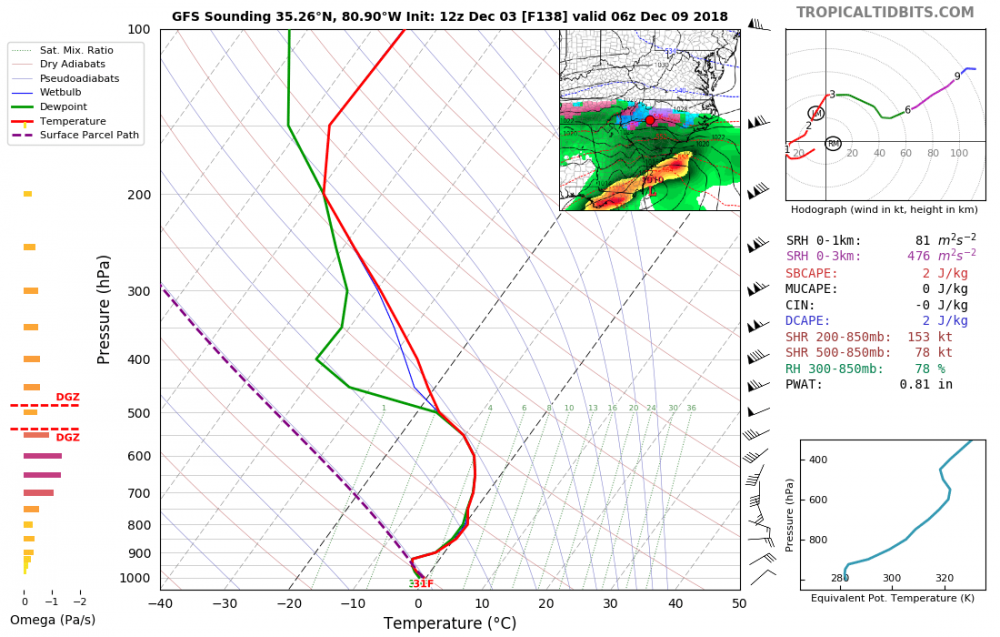
soundings for clt aren't good verbatim. a lot of sleet and frz rain with plain cold rain to start.
-
31 and sleet for clt in the middle of the storm.
-
1 minute ago, eyewall said:
If it verifies. It could end up easily putting me in the sanitarium lol. I miss snow already, and in VT they have had an epic November. I am just happy I was there for the Pi Day event in 2017 with my first ever 30 incher:
good lord, i cannot imagine.
-
4 minutes ago, eyewall said:
It is far from the perfect track for the RDU area on the overnight Euro, but there would be at least a backside deform band for a couple of hours and a quick couple of inches in that scenario I would think. Otherwise it would be mostly rain/mixed-p . Obviously that will shift again and it is a single op run so we shall see. We are far from full consensus at this time.
what a nice storm to welcome you back to the SE snow reality. hoping for the best but expecting the worst.
-
1
-
-
1 minute ago, Ericjcrash said:
Lmao. Well so far this season CAD was grossly underestimated in the mid November storm so that may be something to watch.
that is one thing that gives me a little hope, if we can get cad to over perform we will be in really good shape as qpf doesn't look to be an issue at all.
-
1 minute ago, Ericjcrash said:
Congrats guys. Looking like a generational event is on deck down there. Then again in the off chance the Canadian is right I'm a happy camper. Definitely looking like it will stay suppressed at this stage.
if we got even half the fantasy storms models showed 150hrs out for our area we'd have snowfall totals similar to buffalo. we will likely find a way to screw it up.
-
5
-
-
4 minutes ago, FallsLake said:
The strength of the CAD / supporting high is crucial. Hopefully there is more transition zones. When this occurs our area does well with wintery precip. If there is a sharp snow/rain line somebody in our area (to Charlotte to the SC up state) is going to be unhappy. I still think the December 2009 storm is a possibility. Miller A with good snow totals in the western piedmont but a messy snow to rain event for RDU.
agree. we have seen so many times the past few years to take these clown maps with a grain of salt. expect mainly sleet and rain and then any snow you get will be a bonus. i don't care if every ensemble shows 12"+ (see RDU in Jan 2017), I won't expect a thing until snow is actually falling and accumulating. nam should be able to sniff out the transition zones and problem areas around 36-48hrs out.
-
5
-
-
lp location is nearly identical to 18z, hp just not cutting it
-
much warmer at 144, nice cold rain for much of nc.
-
1
-
1
-
-
6 minutes ago, downeastnc said:
Right but they wobble....its done this all afternoon....averaged out it looks like this....
watch the radar, it is moving wnw, storms dont travel in a straight line. *click to animate

-
1
-
1
-
-
12 minutes ago, thunderwolf said:
I can agree with this assessment. NHC still shows the movement as of the 1pm update NW at 10 mph.
recon shows a near due west turn over the past 3 passes.
-
9 minutes ago, shaggy said:
Problem is she has consistently been on the very northern edge of the guidance and damn near left the cone yesterday. I posted their disco about continuing it NW today due to the "well established" ridge.
She may putthe brakes on and go due wnw right now but she hasn't done it yet and each hour that she moves NW puts her having to make a sharper turn. This could have large implications into central and eastern NC.
per the most recent recon pass the center as already begun the turn.

-
2
-
-
3 minutes ago, ryan1234 said:
It appears that she is already moving more to the west. Almost every model has her moving W then WSW. Now she may not make "hard south turn, but it's hard to go against modeling when there seems to be a general consensus.
yeah, a lot of wishcasting it into northern nc it seems. literally every model shows a nw drift followed by a west southwest turn.
-
3
-
-
3k nam is ridiculous, widespread 10"+ totals inland and still raining late saturday.
-
11 minutes ago, tramadoc said:
Looks to my untrained eye that if it continues on the track it's on (looks like almost NNW) that it would make landfall around Beaufort, NC.
Sent from my SM-N950U using Tapatalk
you can see the slowdown and slow drift westward here
https://radar.weather.gov/radar.php?rid=MHX&product=N0Z&overlay=11101111&loop=yes
-
3
-

Southeast Sanitarium - A Place to Vent
in Southeastern States
Posted
charlotte to raleigh, toss in the towel. not sure we even see snowflakes at this point. writing is on the wall.